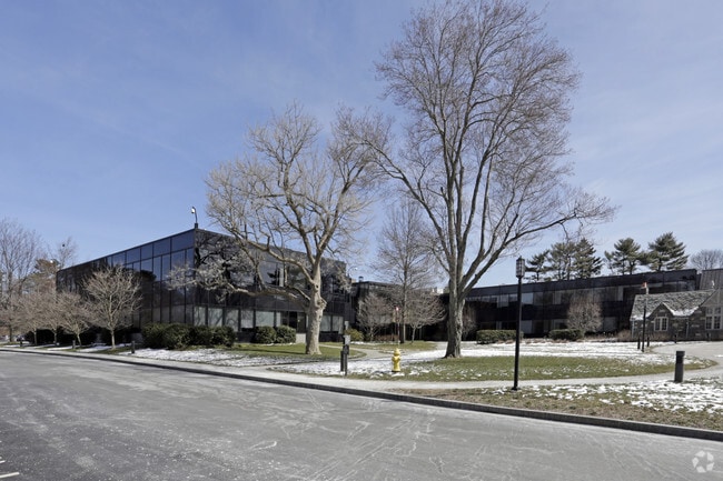
Property Record
40 Highland Ave, Norwalk, CT 06853

NEARBY LISTINGS FOR SALE OR LEASE
Property Detail
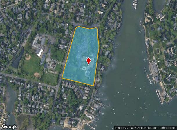
40 Highland Ave
NORW-000006-000016C-000001
Fairfield
Commercialnec
Connecticut
X
1
09001C0533G
15.48 AC
2025
Norwalk
2025
Westchester/So Connecticut
044600
Bridgeport-Stamford-Norwalk, CT
DEMOGRAPHICS near 40 Highland Ave
1 Mile
3 Mile
5 Mile
2024 Total Population
4,628
46,141
137,774
2029 Population
4,680
46,164
137,509
Pop Growth 2024-2029
+ 1.12%
+ 0.05%
(0.19%)
Average Age
41
39
39
2024 Total Households
1,691
17,150
51,709
HH Growth 2024-2029
+ 1.01%
+ 0.03%
(0.21%)
Median Household Inc
$226,283
$97,698
$95,275
Avg Household Size
2.70
2.60
2.60
2024 Avg HH Vehicles
2.00
2.00
2.00
Median Home Value
$1,071,383
$708,667
$543,665
Median Year Built
1956
1961
1963
Nearby Places
Map Layers
Map Styles
 Street
 Aerial
- Restaurants
- Banks
- Shops
- Fitness
- Groceries
PUBLIC TRANSPORTATION
COMMUTER RAIL
Rowayton Station (New Haven Line - Metro-North Commuter Railroad Company (Metro-North))
DRIVE
WALK
Distance
Rowayton Station (New Haven Line - Metro-North Commuter Railroad Company (Metro-North))
4 min
1.6 mi
Darien Station (New Haven Line - Metro-North Commuter Railroad Company (Metro-North))
DRIVE
WALK
Distance
Darien Station (New Haven Line - Metro-North Commuter Railroad Company (Metro-North))
6 min
2.7 mi
AIRPORT
Westchester County
DRIVE
WALK
Distance
Westchester County
33 min
19.4 mi
Freight Ports
Port of New Haven
DRIVE
WALK
Distance
Port of New Haven
54 min
36.8 mi
Nearby Properties
Address
Land Use
TOTAL SIZE
Lot Size
Zoning
Address
Land Use
TOTAL SIZE
Lot Size
Zoning
39,031 SF
451.38 AC
ADD
Address
Land Use
TOTAL SIZE
Lot Size
Zoning
124,373 SF
13.87 AC
A2
Address
Land Use
TOTAL SIZE
Lot Size
Zoning
17 AC
A2
Address
Land Use
TOTAL SIZE
Lot Size
Zoning
Address
Land Use
TOTAL SIZE
Lot Size
Zoning
128,459 SF
1.49 AC
I1
Address
Land Use
TOTAL SIZE
Lot Size
Zoning
45.90 AC
R-1
Address
Land Use
TOTAL SIZE
Lot Size
Zoning
130,394 SF
28.72 AC
B
Address
Land Use
TOTAL SIZE
Lot Size
Zoning
200,704 SF
Address
Land Use
TOTAL SIZE
Lot Size
Zoning
9.76 AC
B1
Address
Land Use
TOTAL SIZE
Lot Size
Zoning
132,185 SF
3.99 AC
DO
Address
Land Use
TOTAL SIZE
Lot Size
Zoning
141,174 SF
10.75 AC
B2
Address
Land Use
TOTAL SIZE
Lot Size
Zoning
3.40 AC
RPDD
Address
Land Use
TOTAL SIZE
Lot Size
Zoning
119,531 SF
17.92 AC
D
Address
Land Use
TOTAL SIZE
Lot Size
Zoning
12.71 AC
B2
Address
Land Use
TOTAL SIZE
Lot Size
Zoning
10.53 AC
B2
Address
Land Use
TOTAL SIZE
Lot Size
Zoning
110,187 SF
10.09 AC
B2
Address
Land Use
TOTAL SIZE
Lot Size
Zoning
4,378 SF
1.46 AC
NB
Address
Land Use
TOTAL SIZE
Lot Size
Zoning
9.60 AC
MU
Address
Land Use
TOTAL SIZE
Lot Size
Zoning
9.75 AC
B2
Address
Land Use
TOTAL SIZE
Lot Size
Zoning
96,563 SF
9.49 AC
DC
Address
Land Use
TOTAL SIZE
Lot Size
Zoning
24,704 SF
1.52 AC
I1
Address
Land Use
TOTAL SIZE
Lot Size
Zoning
135,048 SF
1.90 AC
WSDD
Address
Land Use
TOTAL SIZE
Lot Size
Zoning
133,560 SF
2.30 AC
I1
Address
Land Use
TOTAL SIZE
Lot Size
Zoning
84,515 SF
16.31 AC
MU
Address
Land Use
TOTAL SIZE
Lot Size
Zoning
72,796 SF
8.30 AC
MU
Address
Land Use
TOTAL SIZE
Lot Size
Zoning
214,830 SF
RPDA
Address
Land Use
TOTAL SIZE
Lot Size
Zoning
217,220 SF
RPDA
Address
Land Use
TOTAL SIZE
Lot Size
Zoning
11.84 AC
B2
Address
Land Use
TOTAL SIZE
Lot Size
Zoning
84,097 SF
9.09 AC
B1
Address
Land Use
TOTAL SIZE
Lot Size
Zoning
144,366 SF
10.04 AC
B2
The World's #1 Commercial Real Estate Marketplace
Connect with us
© 2025 CoStar Group
The information above has been obtained from sources believed reliable. While we do not doubt its accuracy we have not verified it and make no guarantee, warranty or representation about it. It is your responsibility to independently confirm its accuracy and completeness. Any projections, opinions, assumptions, or estimates used are for example only and do not represent the current or future performance of the property. The value of this transaction to you depends on tax and other factors which should be evaluated by your tax, financial, and legal advisors. You and your advisors should conduct a careful, independent investigation of the property to determine to your satisfaction the suitability of the property for your needs.