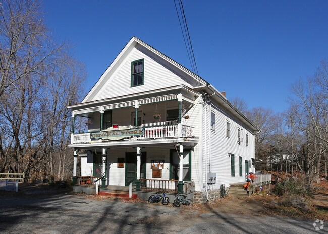
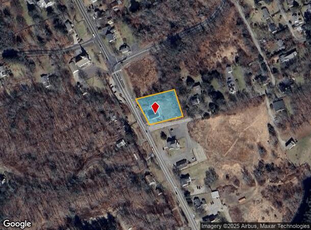
Property Record
534 Storrs Rd, Mansfield Center, CT 06250

NEARBY LISTINGS FOR SALE OR LEASE
Property Detail
534 Storrs Rd
Hartford-West Hartford-East Hartford, CT
Forest Edge Condo
MANS-000029-000114-000063
Tolland
Commercialbuilding
Connecticut
2025
63
2025
0.60 AC
881100
Tolland County
3,000 SF
Hartford
DEMOGRAPHICS near 534 Storrs Rd
1 Mile
3 Mile
5 Mile
2024 Total Population
756
11,513
50,329
2029 Population
749
11,563
50,217
Pop Growth 2024-2029
(0.93%)
+ 0.43%
(0.22%)
Average Age
43
39
34
2024 Total Households
309
4,437
14,711
HH Growth 2024-2029
(0.97%)
+ 0.27%
(0.29%)
Median Household Inc
$100,893
$51,187
$50,493
Avg Household Size
2.30
2.30
2.30
2024 Avg HH Vehicles
2.00
2.00
2.00
Median Home Value
$282,638
$229,750
$218,532
Median Year Built
1964
1976
1966
Nearby Places
Map Layers
Map Styles
 Street
 Aerial
- Restaurants
- Banks
- Shops
- Fitness
- Groceries
PUBLIC TRANSPORTATION
AIRPORT
Bradley International
DRIVE
WALK
Distance
Bradley International
59 min
40.2 mi
Freight Ports
Port of Davisville, RI
DRIVE
WALK
Distance
Port of Davisville, RI
86 min
60.6 mi
SALE & LEASE HISTORY
LISTING DATE
SALE/LEASE

Sep 25, 2016
For Lease
Nov 11, 2017
For Lease
Dec 05, 2023
For Lease
Nearby Properties
Address
Land Use
TOTAL SIZE
Lot Size
Zoning
Address
Land Use
TOTAL SIZE
Lot Size
Zoning
47,712 SF
1 AC
I
Address
Land Use
TOTAL SIZE
Lot Size
Zoning
176,832 SF
I
Address
Land Use
TOTAL SIZE
Lot Size
Zoning
Address
Land Use
TOTAL SIZE
Lot Size
Zoning
145,144 SF
R6
Address
Land Use
TOTAL SIZE
Lot Size
Zoning
79,493 SF
16.10 AC
RAR90
Address
Land Use
TOTAL SIZE
Lot Size
Zoning
14.50 AC
R20
Address
Land Use
TOTAL SIZE
Lot Size
Zoning
90,450 SF
R6
Address
Land Use
TOTAL SIZE
Lot Size
Zoning
99,901 SF
1 AC
I
Address
Land Use
TOTAL SIZE
Lot Size
Zoning
61,837 SF
I
Address
Land Use
TOTAL SIZE
Lot Size
Zoning
102,324 SF
1 AC
I
Address
Land Use
TOTAL SIZE
Lot Size
Zoning
99,139 SF
R6
Address
Land Use
TOTAL SIZE
Lot Size
Zoning
316,812 SF
39.88 AC
R4
Address
Land Use
TOTAL SIZE
Lot Size
Zoning
126,220 SF
1 AC
I
Address
Land Use
TOTAL SIZE
Lot Size
Zoning
93.53 AC
RAR90
Address
Land Use
TOTAL SIZE
Lot Size
Zoning
86,684 SF
1 AC
I
Address
Land Use
TOTAL SIZE
Lot Size
Zoning
152 AC
I
Address
Land Use
TOTAL SIZE
Lot Size
Zoning
275,230 SF
27.63 AC
PB1
Address
Land Use
TOTAL SIZE
Lot Size
Zoning
6,340 SF
I
Address
Land Use
TOTAL SIZE
Lot Size
Zoning
231.54 AC
C2A
Address
Land Use
TOTAL SIZE
Lot Size
Zoning
1,552 SF
10.06 AC
DMR
Address
Land Use
TOTAL SIZE
Lot Size
Zoning
90.58 AC
M1
Address
Land Use
TOTAL SIZE
Lot Size
Zoning
131 SF
M1 - 1
Address
Land Use
TOTAL SIZE
Lot Size
Zoning
70,200 SF
1 AC
I
Address
Land Use
TOTAL SIZE
Lot Size
Zoning
168,728 SF
24.40 AC
C4
Address
Land Use
TOTAL SIZE
Lot Size
Zoning
174 SF
R5
Address
Land Use
TOTAL SIZE
Lot Size
Zoning
35,941 SF
1 AC
I
Address
Land Use
TOTAL SIZE
Lot Size
Zoning
317,945 SF
2 AC
I
Address
Land Use
TOTAL SIZE
Lot Size
Zoning
12.04 AC
PB1
Address
Land Use
TOTAL SIZE
Lot Size
Zoning
45,068 SF
1 AC
I
Address
Land Use
TOTAL SIZE
Lot Size
Zoning
46,760 SF
1 AC
I
The World's #1 Commercial Real Estate Marketplace
Connect with us
© 2025 CoStar Group
The information above has been obtained from sources believed reliable. While we do not doubt its accuracy we have not verified it and make no guarantee, warranty or representation about it. It is your responsibility to independently confirm its accuracy and completeness. Any projections, opinions, assumptions, or estimates used are for example only and do not represent the current or future performance of the property. The value of this transaction to you depends on tax and other factors which should be evaluated by your tax, financial, and legal advisors. You and your advisors should conduct a careful, independent investigation of the property to determine to your satisfaction the suitability of the property for your needs.