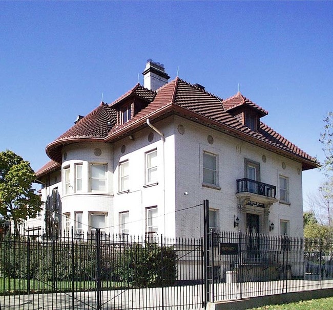
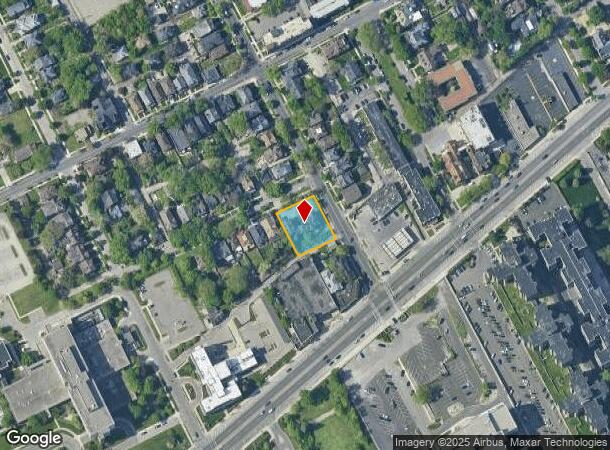
Property Record
649 Van Dyke St, Detroit, MI 48214

NEARBY LISTINGS FOR SALE OR LEASE
Property Detail
649 Van Dyke St
Detroit-Warren-Dearborn, MI
Charles Bewicks
17-0103323
Wayne
Duplex
Michigan
X
0.39 AC
26163C0301F
Detroit E of Woodward
5,042 SF
Detroit
DEMOGRAPHICS near 649 Van Dyke St
1 Mile
3 Mile
5 Mile
2024 Total Population
13,182
64,224
203,634
2029 Population
13,055
64,281
202,350
Pop Growth 2024-2029
(0.96%)
+ 0.09%
(0.63%)
Average Age
47
43
39
2024 Total Households
7,818
32,389
88,785
HH Growth 2024-2029
(1.06%)
(0.36%)
(0.63%)
Median Household Inc
$38,563
$36,804
$38,574
Avg Household Size
1.60
1.90
2.20
2024 Avg HH Vehicles
1.00
1.00
1.00
Median Home Value
$248,606
$136,132
$129,224
Median Year Built
1949
1958
1949
Nearby Places
Map Layers
Map Styles
 Street
 Aerial
- Restaurants
- Banks
- Shops
- Fitness
- Groceries
PUBLIC TRANSPORTATION
COMMUTER RAIL
DRIVE
WALK
Distance
17 min
6.3 mi
DRIVE
WALK
Distance
14 min
6.3 mi
AIRPORT
Windsor International
DRIVE
WALK
Distance
Windsor International
30 min
12.1 mi
Detroit Metro Wayne County
DRIVE
WALK
Distance
Detroit Metro Wayne County
42 min
27.2 mi
Freight Ports
DRIVE
WALK
Distance
83 min
64.6 mi
Nearby Properties
Address
Land Use
TOTAL SIZE
Lot Size
Zoning
Address
Land Use
TOTAL SIZE
Lot Size
Zoning
6,112,830 SF
13.67 AC
PD
Address
Land Use
TOTAL SIZE
Lot Size
Zoning
1,553,311 SF
3.05 AC
SD5
Address
Land Use
TOTAL SIZE
Lot Size
Zoning
1,994,989 SF
4.97 AC
B5
Address
Land Use
TOTAL SIZE
Lot Size
Zoning
1,478,866 SF
2.88 AC
PCA
Address
Land Use
TOTAL SIZE
Lot Size
Zoning
1,847,449 SF
13.85 AC
PD
Address
Land Use
TOTAL SIZE
Lot Size
Zoning
1,004,872 SF
1.05 AC
PCA
Address
Land Use
TOTAL SIZE
Lot Size
Zoning
2,958,207 SF
277.38 AC
M4
Address
Land Use
TOTAL SIZE
Lot Size
Zoning
919,213 SF
B5
Address
Land Use
TOTAL SIZE
Lot Size
Zoning
874,160 SF
9.91 AC
R6
Address
Land Use
TOTAL SIZE
Lot Size
Zoning
520,897 SF
0.85 AC
Address
Land Use
TOTAL SIZE
Lot Size
Zoning
430,286 SF
1.14 AC
PCA
Address
Land Use
TOTAL SIZE
Lot Size
Zoning
437,558 SF
0.72 AC
Address
Land Use
TOTAL SIZE
Lot Size
Zoning
167,719 SF
2.18 AC
SD5
Address
Land Use
TOTAL SIZE
Lot Size
Zoning
460,475 SF
3.49 AC
R6
Address
Land Use
TOTAL SIZE
Lot Size
Zoning
324,379 SF
4.97 AC
B5
Address
Land Use
TOTAL SIZE
Lot Size
Zoning
511,056 SF
0.81 AC
PCA
Address
Land Use
TOTAL SIZE
Lot Size
Zoning
505,170 SF
1.12 AC
PD
Address
Land Use
TOTAL SIZE
Lot Size
Zoning
149,873 SF
1.02 AC
SD5
Address
Land Use
TOTAL SIZE
Lot Size
Zoning
286,897 SF
416 AC
R6
Address
Land Use
TOTAL SIZE
Lot Size
Zoning
2,005,073 SF
108.66 AC
M4
Address
Land Use
TOTAL SIZE
Lot Size
Zoning
302,517 SF
2.50 AC
B4
Address
Land Use
TOTAL SIZE
Lot Size
Zoning
461,840 SF
4.78 AC
R6
Address
Land Use
TOTAL SIZE
Lot Size
Zoning
192,497 SF
B5
Address
Land Use
TOTAL SIZE
Lot Size
Zoning
12.16 AC
PD
Address
Land Use
TOTAL SIZE
Lot Size
Zoning
596,304 SF
2.57 AC
R6
Address
Land Use
TOTAL SIZE
Lot Size
Zoning
82,528 SF
6.03 AC
PD
Address
Land Use
TOTAL SIZE
Lot Size
Zoning
188,032 SF
0.83 AC
B6
Address
Land Use
TOTAL SIZE
Lot Size
Zoning
384,217 SF
3.40 AC
R6
Address
Land Use
TOTAL SIZE
Lot Size
Zoning
417,948 SF
2.18 AC
B6
Address
Land Use
TOTAL SIZE
Lot Size
Zoning
606,720 SF
2.12 AC
PD
The World's #1 Commercial Real Estate Marketplace
Connect with us
© 2025 CoStar Group
The information above has been obtained from sources believed reliable. While we do not doubt its accuracy we have not verified it and make no guarantee, warranty or representation about it. It is your responsibility to independently confirm its accuracy and completeness. Any projections, opinions, assumptions, or estimates used are for example only and do not represent the current or future performance of the property. The value of this transaction to you depends on tax and other factors which should be evaluated by your tax, financial, and legal advisors. You and your advisors should conduct a careful, independent investigation of the property to determine to your satisfaction the suitability of the property for your needs.