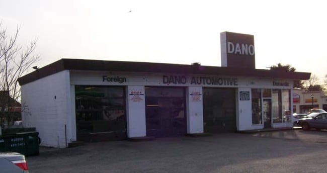
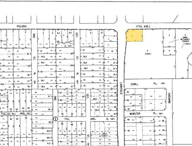
Property Record
255 Pulaski Rd, East Northport, NY 11731

Property Detail
255 Pulaski Rd
Nassau County-Suffolk County, NY
BLK LOT
0400-119-00-02-00-001-000
Suffolk
Servicestation
New York
C6
1
B and X Area of moderate flood hazard, usually the area between the limits of the 100-year and 500-year floods.
0.59 AC
2024
Western Suffolk
2025
Long Island (New York)
134702
NEARBY LISTINGS FOR SALE OR LEASE
DEMOGRAPHICS near 255 Pulaski Rd
1 mile
3 mile
5 mile
2025 Total Population
12,938
68,382
161,575
2030 Population
12,694
67,583
159,998
Pop Growth 2025-2030
(1.89%)
(1.17%)
(0.98%)
Average Age
42
43
43
2025 Total Households
4,469
23,325
54,243
HH Growth 2025-2030
(2.35%)
(1.53%)
(1.32%)
Median Household Inc
$152,131
$161,869
$157,289
Avg Household Size
2.80
2.80
2.90
2025 Avg HH Vehicles
2.00
2.00
2.00
Median Home Value
$696,404
$747,059
$746,752
Median Year Built
1958
1961
1962
Nearby Places
Map Layers
Map Styles
 Street
 Aerial
Layers
 Traffic
 Biking
Places
Listings with unknown addresses are not visible on the map
- Restaurants
- Banks
- Shops
- Fitness
- Groceries
PUBLIC TRANSPORTATION
COMMUTER RAIL
Northport Station (Port Jefferson Branch - Long Island Rail Road)
Drive
Walk
Distance
Northport Station (Port Jefferson Branch - Long Island Rail Road)
1 min
8 min
0.5 mi
Greenlawn Station (Port Jefferson Branch - Long Island Rail Road)
Drive
Walk
Distance
Greenlawn Station (Port Jefferson Branch - Long Island Rail Road)
5 min
2.7 mi
AIRPORT
Long Island MacArthur
Drive
Walk
Distance
Long Island MacArthur
27 min
15.6 mi
John F Kennedy International
Drive
Walk
Distance
John F Kennedy International
56 min
38.7 mi
Freight Ports
Port of New Haven
Drive
Walk
Distance
Port of New Haven
139 min
56.8 mi
Nearby Properties
Address
Land Use
TOTAL SIZE
Lot Size
Zoning
Address
Land Use
TOTAL SIZE
Lot Size
Zoning
63,722 SF
0.42 AC
VILLA
Address
Land Use
TOTAL SIZE
Lot Size
Zoning
26.60 AC
Address
Land Use
TOTAL SIZE
Lot Size
Zoning
0.41 AC
VILLA
Address
Land Use
TOTAL SIZE
Lot Size
Zoning
300 AC
R80
Address
Land Use
TOTAL SIZE
Lot Size
Zoning
2,764 SF
0.24 AC
HC
Address
Land Use
TOTAL SIZE
Lot Size
Zoning
1 AC
VILLA
Address
Land Use
TOTAL SIZE
Lot Size
Zoning
1,416 SF
0.86 AC
A
Address
Land Use
TOTAL SIZE
Lot Size
Zoning
8.80 AC
R10
Address
Land Use
TOTAL SIZE
Lot Size
Zoning
6.50 AC
R40
Address
Land Use
TOTAL SIZE
Lot Size
Zoning
0.59 AC
R20
Address
Land Use
TOTAL SIZE
Lot Size
Zoning
42.20 AC
I1
Address
Land Use
TOTAL SIZE
Lot Size
Zoning
44.90 AC
R40
Address
Land Use
TOTAL SIZE
Lot Size
Zoning
30.80 AC
R40
Address
Land Use
TOTAL SIZE
Lot Size
Zoning
10.14 AC
RRM
Address
Land Use
TOTAL SIZE
Lot Size
Zoning
0.46 AC
R20
Address
Land Use
TOTAL SIZE
Lot Size
Zoning
12 AC
RRM
Address
Land Use
TOTAL SIZE
Lot Size
Zoning
19.56 AC
C5
Address
Land Use
TOTAL SIZE
Lot Size
Zoning
Address
Land Use
TOTAL SIZE
Lot Size
Zoning
14.83 AC
R85
Address
Land Use
TOTAL SIZE
Lot Size
Zoning
16.54 AC
Address
Land Use
TOTAL SIZE
Lot Size
Zoning
15.80 AC
Address
Land Use
TOTAL SIZE
Lot Size
Zoning
16.10 AC
C5
Address
Land Use
TOTAL SIZE
Lot Size
Zoning
35.04 AC
R40
Address
Land Use
TOTAL SIZE
Lot Size
Zoning
44.60 AC
R40
Address
Land Use
TOTAL SIZE
Lot Size
Zoning
44.62 AC
R40
Address
Land Use
TOTAL SIZE
Lot Size
Zoning
Address
Land Use
TOTAL SIZE
Lot Size
Zoning
10.60 AC
RRM
Address
Land Use
TOTAL SIZE
Lot Size
Zoning
6 AC
I5
Address
Land Use
TOTAL SIZE
Lot Size
Zoning
86.30 AC
Address
Land Use
TOTAL SIZE
Lot Size
Zoning
28.25 AC
R40
The World's #1 Commercial Real Estate Marketplace
Connect with us
© 2026 CoStar Group
The information above has been obtained from sources believed reliable. While we do not doubt its accuracy we have not verified it and make no guarantee, warranty or representation about it. It is your responsibility to independently confirm its accuracy and completeness. Any projections, opinions, assumptions, or estimates used are for example only and do not represent the current or future performance of the property. The value of this transaction to you depends on tax and other factors which should be evaluated by your tax, financial, and legal advisors. You and your advisors should conduct a careful, independent investigation of the property to determine to your satisfaction the suitability of the property for your needs.