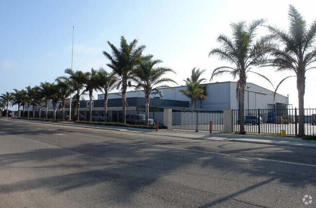
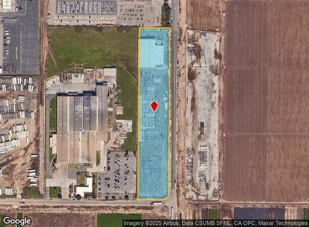
Property Record
5901 Edison Dr, Oxnard, CA 93033

NEARBY LISTINGS FOR SALE OR LEASE
Property Detail
5901 Edison Dr
Oxnard-Thousand Oaks-Ventura, CA
Sub84 Rancho El Rio De Santa Clara O La
231-0-020-320
LOT: A REF: 26 PM 15
Portharbor
Ventura
X
California
06111C0918F
a
0
5.01 AC
2025
Oxnard/Pt Hueneme
004715
Los Angeles
DEMOGRAPHICS near 5901 Edison Dr
1 Mile
3 Mile
5 Mile
2024 Total Population
9,404
87,135
172,361
2029 Population
9,295
86,025
170,315
Pop Growth 2024-2029
(1.16%)
(1.27%)
(1.19%)
Average Age
33
35
37
2024 Total Households
2,108
20,953
45,779
HH Growth 2024-2029
(1.28%)
(1.14%)
(0.91%)
Median Household Inc
$71,176
$75,924
$79,023
Avg Household Size
4.30
3.90
3.50
2024 Avg HH Vehicles
3.00
2.00
2.00
Median Home Value
$441,428
$474,928
$559,623
Median Year Built
1974
1969
1972
Nearby Places
Map Layers
Map Styles
 Street
 Aerial
- Restaurants
- Banks
- Shops
- Fitness
- Groceries
PUBLIC TRANSPORTATION
COMMUTER RAIL
Oxnard (Ventura County Line - Southern California Regional Rail Authority (Metrolink))
DRIVE
WALK
Distance
Oxnard (Ventura County Line - Southern California Regional Rail Authority (Metrolink))
10 min
4.7 mi
East Ventura Metrolink Station (Metrolink Ventura County Line - Metrolink Trains)
DRIVE
WALK
Distance
East Ventura Metrolink Station (Metrolink Ventura County Line - Metrolink Trains)
17 min
9.2 mi
Freight Ports
The Port of Hueneme
DRIVE
WALK
Distance
The Port of Hueneme
6 min
2.5 mi
Nearby Properties
Address
Land Use
TOTAL SIZE
Lot Size
Zoning
Address
Land Use
TOTAL SIZE
Lot Size
Zoning
90,086 SF
10.48 AC
CDI
Address
Land Use
TOTAL SIZE
Lot Size
Zoning
129,018 SF
5.09 AC
R3PD
Address
Land Use
TOTAL SIZE
Lot Size
Zoning
133,174 SF
5.94 AC
R3PD
Address
Land Use
TOTAL SIZE
Lot Size
Zoning
157,108 SF
21.40 AC
MULT
Address
Land Use
TOTAL SIZE
Lot Size
Zoning
20,349 SF
9.65 AC
C2
Address
Land Use
TOTAL SIZE
Lot Size
Zoning
81,233 SF
3.29 AC
R3PD
Address
Land Use
TOTAL SIZE
Lot Size
Zoning
79,117 SF
3.25 AC
R3PD
Address
Land Use
TOTAL SIZE
Lot Size
Zoning
14,931 SF
14.08 AC
Address
Land Use
TOTAL SIZE
Lot Size
Zoning
2,264 SF
13.03 AC
M1
Address
Land Use
TOTAL SIZE
Lot Size
Zoning
200.55 AC
AE-40
Address
Land Use
TOTAL SIZE
Lot Size
Zoning
80,002 SF
3.16 AC
MLPD
Address
Land Use
TOTAL SIZE
Lot Size
Zoning
79,556 SF
4.54 AC
Address
Land Use
TOTAL SIZE
Lot Size
Zoning
81,052 SF
11.23 AC
M1PD
Address
Land Use
TOTAL SIZE
Lot Size
Zoning
48,720 SF
2.76 AC
R2PD
Address
Land Use
TOTAL SIZE
Lot Size
Zoning
32,410 SF
1.40 AC
MLPD
Address
Land Use
TOTAL SIZE
Lot Size
Zoning
2.76 AC
BRP
Address
Land Use
TOTAL SIZE
Lot Size
Zoning
41,930 SF
24.33 AC
AE
Address
Land Use
TOTAL SIZE
Lot Size
Zoning
80,440 SF
6.80 AC
M2
Address
Land Use
TOTAL SIZE
Lot Size
Zoning
58,400 SF
4.89 AC
Address
Land Use
TOTAL SIZE
Lot Size
Zoning
Address
Land Use
TOTAL SIZE
Lot Size
Zoning
64,880 SF
3.91 AC
R2PD
Address
Land Use
TOTAL SIZE
Lot Size
Zoning
37,440 SF
2.28 AC
R2PD
Address
Land Use
TOTAL SIZE
Lot Size
Zoning
101,740 SF
5.46 AC
M1PD
Address
Land Use
TOTAL SIZE
Lot Size
Zoning
81,381 SF
16.18 AC
MULT
Address
Land Use
TOTAL SIZE
Lot Size
Zoning
66,390 SF
7.09 AC
CDI
Address
Land Use
TOTAL SIZE
Lot Size
Zoning
33,756 SF
1.19 AC
C2PD
Address
Land Use
TOTAL SIZE
Lot Size
Zoning
31,631 SF
2.45 AC
Address
Land Use
TOTAL SIZE
Lot Size
Zoning
122,512 SF
3.51 AC
Address
Land Use
TOTAL SIZE
Lot Size
Zoning
37,500 SF
1.37 AC
Address
Land Use
TOTAL SIZE
Lot Size
Zoning
30,953 SF
7.30 AC
ML
The World's #1 Commercial Real Estate Marketplace
Connect with us
© 2025 CoStar Group
The information above has been obtained from sources believed reliable. While we do not doubt its accuracy we have not verified it and make no guarantee, warranty or representation about it. It is your responsibility to independently confirm its accuracy and completeness. Any projections, opinions, assumptions, or estimates used are for example only and do not represent the current or future performance of the property. The value of this transaction to you depends on tax and other factors which should be evaluated by your tax, financial, and legal advisors. You and your advisors should conduct a careful, independent investigation of the property to determine to your satisfaction the suitability of the property for your needs.