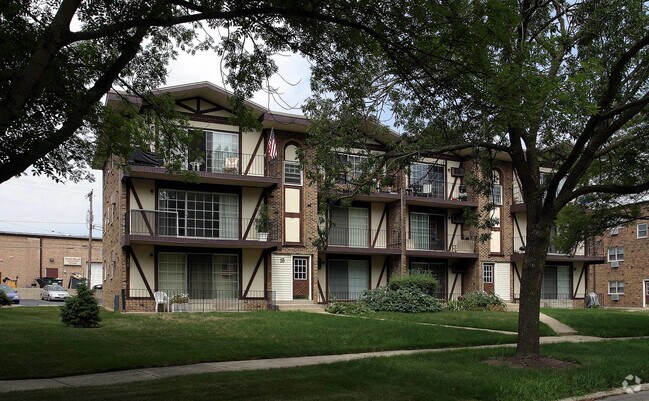
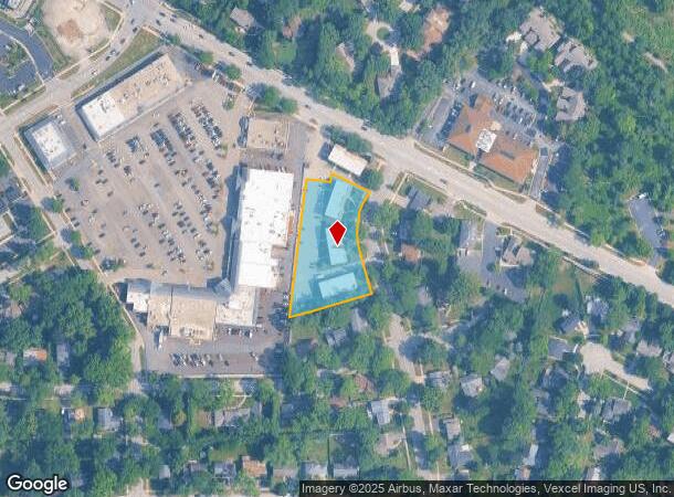
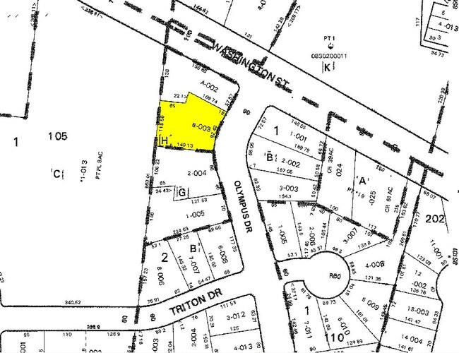
Property Record
21 Olympus Dr, Naperville, IL 60540
NEARBY LISTINGS FOR SALE OR LEASE
-
-
View all Naperville listings for sale on LoopNet.com
Property Detail
21 Olympus Dr
Chicago-Naperville-Elgin, IL-IN-WI
The Olympus Gardens Condo
08-30-124-026
DuPage
Condominium
Illinois
X
1.34 AC
17043C0144J
West Highlands
549 SF
Chicago
DEMOGRAPHICS near 21 Olympus Dr
1 Mile
3 Mile
5 Mile
2024 Total Population
12,260
98,844
243,103
2029 Population
12,125
97,477
240,283
Pop Growth 2024-2029
(1.10%)
(1.38%)
(1.16%)
Average Age
41
41
40
2024 Total Households
4,088
35,570
89,934
HH Growth 2024-2029
(1.20%)
(1.41%)
(1.19%)
Median Household Inc
$155,862
$136,526
$115,808
Avg Household Size
2.80
2.70
2.60
2024 Avg HH Vehicles
2.00
2.00
2.00
Median Home Value
$449,955
$446,431
$384,008
Median Year Built
1972
1982
1985
Nearby Places
Map Layers
Map Styles
 Street
 Aerial
- Restaurants
- Banks
- Shops
- Fitness
- Groceries
PUBLIC TRANSPORTATION
COMMUTER RAIL
Naperville Station (Burlington Northern-Santa Fe Railway Line - Northeast Illinois Regional Commuter Railroad (Metra))
DRIVE
WALK
Distance
Naperville Station (Burlington Northern-Santa Fe Railway Line - Northeast Illinois Regional Commuter Railroad (Metra))
7 min
2.3 mi
Route 59 Station (Burlington Northern-Santa Fe Railway Line - Northeast Illinois Regional Commuter Railroad (Metra))
DRIVE
WALK
Distance
Route 59 Station (Burlington Northern-Santa Fe Railway Line - Northeast Illinois Regional Commuter Railroad (Metra))
14 min
6.0 mi
AIRPORT
Chicago Midway International
DRIVE
WALK
Distance
Chicago Midway International
37 min
22.7 mi
Chicago O'Hare International
DRIVE
WALK
Distance
Chicago O'Hare International
46 min
29.3 mi
Nearby Properties
Address
Land Use
TOTAL SIZE
Lot Size
Zoning
Address
Land Use
TOTAL SIZE
Lot Size
Zoning
29.20 AC
C
Address
Land Use
TOTAL SIZE
Lot Size
Zoning
6.03 AC
M
Address
Land Use
TOTAL SIZE
Lot Size
Zoning
Address
Land Use
TOTAL SIZE
Lot Size
Zoning
272,400 SF
20.94 AC
C
Address
Land Use
TOTAL SIZE
Lot Size
Zoning
16.28 AC
M
Address
Land Use
TOTAL SIZE
Lot Size
Zoning
166,222 SF
8.81 AC
C
Address
Land Use
TOTAL SIZE
Lot Size
Zoning
13.42 AC
Address
Land Use
TOTAL SIZE
Lot Size
Zoning
127,295 SF
1.44 AC
B
Address
Land Use
TOTAL SIZE
Lot Size
Zoning
133,779 SF
9.77 AC
C
Address
Land Use
TOTAL SIZE
Lot Size
Zoning
177,429 SF
0.79 AC
C
Address
Land Use
TOTAL SIZE
Lot Size
Zoning
184,882 SF
7.25 AC
C
Address
Land Use
TOTAL SIZE
Lot Size
Zoning
179,511 SF
0.73 AC
C
Address
Land Use
TOTAL SIZE
Lot Size
Zoning
106,914 SF
20.39 AC
Address
Land Use
TOTAL SIZE
Lot Size
Zoning
9.79 AC
C
Address
Land Use
TOTAL SIZE
Lot Size
Zoning
2.26 AC
C
Address
Land Use
TOTAL SIZE
Lot Size
Zoning
Address
Land Use
TOTAL SIZE
Lot Size
Zoning
11.87 AC
Address
Land Use
TOTAL SIZE
Lot Size
Zoning
88,369 SF
8.02 AC
Address
Land Use
TOTAL SIZE
Lot Size
Zoning
5.91 AC
Address
Land Use
TOTAL SIZE
Lot Size
Zoning
505,040 SF
46.13 AC
Address
Land Use
TOTAL SIZE
Lot Size
Zoning
94,213 SF
1.01 AC
Address
Land Use
TOTAL SIZE
Lot Size
Zoning
3.65 AC
C
Address
Land Use
TOTAL SIZE
Lot Size
Zoning
147,914 SF
19.05 AC
C
Address
Land Use
TOTAL SIZE
Lot Size
Zoning
Address
Land Use
TOTAL SIZE
Lot Size
Zoning
64,483 SF
0.52 AC
B
Address
Land Use
TOTAL SIZE
Lot Size
Zoning
7.51 AC
C
Address
Land Use
TOTAL SIZE
Lot Size
Zoning
10.65 AC
Address
Land Use
TOTAL SIZE
Lot Size
Zoning
9.20 AC
C
Address
Land Use
TOTAL SIZE
Lot Size
Zoning
1.96 AC
C
Address
Land Use
TOTAL SIZE
Lot Size
Zoning
61,639 SF
0.46 AC
The World's #1 Commercial Real Estate Marketplace
Connect with us
© 2025 CoStar Group
The information above has been obtained from sources believed reliable. While we do not doubt its accuracy we have not verified it and make no guarantee, warranty or representation about it. It is your responsibility to independently confirm its accuracy and completeness. Any projections, opinions, assumptions, or estimates used are for example only and do not represent the current or future performance of the property. The value of this transaction to you depends on tax and other factors which should be evaluated by your tax, financial, and legal advisors. You and your advisors should conduct a careful, independent investigation of the property to determine to your satisfaction the suitability of the property for your needs.