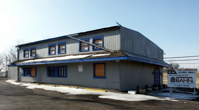
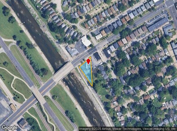
Property Record
6994 Chippewa St, Saint Louis, MO 63109
NEARBY LISTINGS FOR SALE OR LEASE
Property Detail
6994 Chippewa St
St. Louis, MO-IL
St. Louis Hills
6277-00-0010-0
C.B. 6277 CHIPPEWA ST 0.469 ACS CONSOLIDATION SRVY LOT A
Commercialnec
St. Louis City
X
Missouri
29189C0333K
a
2024
0.47 AC
2025
St Louis City South
103100
St. Louis
1,591 SF
DEMOGRAPHICS near 6994 Chippewa St
1 Mile
3 Mile
5 Mile
2024 Total Population
12,539
129,788
339,450
2029 Population
11,648
123,154
324,466
Pop Growth 2024-2029
(7.11%)
(5.11%)
(4.41%)
Average Age
43
41
40
2024 Total Households
6,123
62,391
155,909
HH Growth 2024-2029
(7.14%)
(5.31%)
(4.60%)
Median Household Inc
$72,107
$67,031
$68,205
Avg Household Size
2.00
2.00
2.10
2024 Avg HH Vehicles
2.00
2.00
2.00
Median Home Value
$264,259
$202,665
$234,406
Median Year Built
1950
1949
1949
Nearby Places
Map Layers
Map Styles
 Street
 Aerial
- Restaurants
- Banks
- Shops
- Fitness
- Groceries
PUBLIC TRANSPORTATION
TRANSIT/SUBWAY
Shrewsbury-Lansdowne (Shrewsbury-Lansdowne I-44 Emerson Park - St. Louis MetroLink (MetroLink))
DRIVE
WALK
Distance
Shrewsbury-Lansdowne (Shrewsbury-Lansdowne I-44 Emerson Park - St. Louis MetroLink (MetroLink))
2 min
12 min
0.6 mi
COMMUTER RAIL
Shrewsbury-Lansdowne (Shrewsbury-Lansdowne I-44 Emerson Park - St. Louis MetroLink (MetroLink))
DRIVE
WALK
Distance
Shrewsbury-Lansdowne (Shrewsbury-Lansdowne I-44 Emerson Park - St. Louis MetroLink (MetroLink))
2 min
12 min
0.6 mi
Sunnen (Shrewsbury-Lansdowne I-44 Emerson Park - St. Louis MetroLink (MetroLink))
DRIVE
WALK
Distance
Sunnen (Shrewsbury-Lansdowne I-44 Emerson Park - St. Louis MetroLink (MetroLink))
6 min
2.4 mi
AIRPORT
St Louis Lambert International
DRIVE
WALK
Distance
St Louis Lambert International
24 min
14.5 mi
Scott AFB/Midamerica St Louis
DRIVE
WALK
Distance
Scott AFB/Midamerica St Louis
52 min
33.7 mi
Nearby Properties
Address
Land Use
TOTAL SIZE
Lot Size
Zoning
Address
Land Use
TOTAL SIZE
Lot Size
Zoning
0.92 AC
A
Address
Land Use
TOTAL SIZE
Lot Size
Zoning
5.61 AC
A
Address
Land Use
TOTAL SIZE
Lot Size
Zoning
844,350 SF
63.08 AC
64A1
Address
Land Use
TOTAL SIZE
Lot Size
Zoning
57.77 AC
A
Address
Land Use
TOTAL SIZE
Lot Size
Zoning
559,752 SF
24.37 AC
53R-3
Address
Land Use
TOTAL SIZE
Lot Size
Zoning
322,742 SF
15.04 AC
9LID
Address
Land Use
TOTAL SIZE
Lot Size
Zoning
212,406 SF
21.42 AC
AB
Address
Land Use
TOTAL SIZE
Lot Size
Zoning
198,556 SF
10.12 AC
A
Address
Land Use
TOTAL SIZE
Lot Size
Zoning
44.38 AC
R1
Address
Land Use
TOTAL SIZE
Lot Size
Zoning
158,767 SF
17.01 AC
64A3
Address
Land Use
TOTAL SIZE
Lot Size
Zoning
39,712 SF
30.49 AC
R1
Address
Land Use
TOTAL SIZE
Lot Size
Zoning
3,024 SF
4.73 AC
64A3
Address
Land Use
TOTAL SIZE
Lot Size
Zoning
8,981 SF
10.81 AC
64A3
Address
Land Use
TOTAL SIZE
Lot Size
Zoning
22.44 AC
A
Address
Land Use
TOTAL SIZE
Lot Size
Zoning
227,634 SF
11.28 AC
49C2
Address
Land Use
TOTAL SIZE
Lot Size
Zoning
48,236 SF
16.23 AC
64A1
Address
Land Use
TOTAL SIZE
Lot Size
Zoning
1,176 SF
11.19 AC
64A3
Address
Land Use
TOTAL SIZE
Lot Size
Zoning
375,783 SF
15.42 AC
37MULTI
Address
Land Use
TOTAL SIZE
Lot Size
Zoning
23.21 AC
A
Address
Land Use
TOTAL SIZE
Lot Size
Zoning
106,148 SF
13.01 AC
53C-2
Address
Land Use
TOTAL SIZE
Lot Size
Zoning
489,909 SF
20.11 AC
R4
Address
Land Use
TOTAL SIZE
Lot Size
Zoning
261,362 SF
17.19 AC
R6
Address
Land Use
TOTAL SIZE
Lot Size
Zoning
17.92 AC
64A4
Address
Land Use
TOTAL SIZE
Lot Size
Zoning
181,253 SF
4.66 AC
37MULTI
Address
Land Use
TOTAL SIZE
Lot Size
Zoning
177,070 SF
12 AC
35PUD
Address
Land Use
TOTAL SIZE
Lot Size
Zoning
7.03 AC
PA
Address
Land Use
TOTAL SIZE
Lot Size
Zoning
66,259 SF
19.35 AC
64A4
Address
Land Use
TOTAL SIZE
Lot Size
Zoning
20.27 AC
R5
Address
Land Use
TOTAL SIZE
Lot Size
Zoning
217,910 SF
12.41 AC
53C-2
Address
Land Use
TOTAL SIZE
Lot Size
Zoning
394,790 SF
19.32 AC
K
The World's #1 Commercial Real Estate Marketplace
Connect with us
© 2025 CoStar Group
The information above has been obtained from sources believed reliable. While we do not doubt its accuracy we have not verified it and make no guarantee, warranty or representation about it. It is your responsibility to independently confirm its accuracy and completeness. Any projections, opinions, assumptions, or estimates used are for example only and do not represent the current or future performance of the property. The value of this transaction to you depends on tax and other factors which should be evaluated by your tax, financial, and legal advisors. You and your advisors should conduct a careful, independent investigation of the property to determine to your satisfaction the suitability of the property for your needs.