Property Record
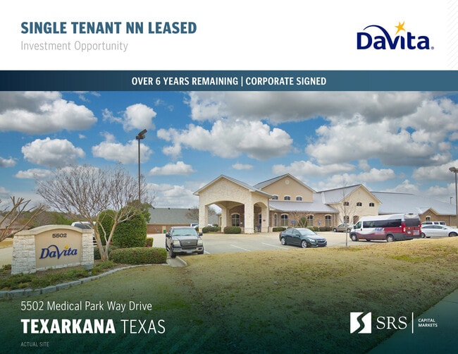
5502 Medical Parkway Dr, Texarkana, TX 75503


NEARBY LISTINGS FOR SALE OR LEASE
Property Detail
5502 Medical Parkway Dr
Texarkana, TX-AR
Galleria Oaks
08310001613
GALLERIA OAKS #1 PARCEL 3 REPLAT #2 LOTS 12-15 & 8A 2016-6912 06/02/16 BLK/TRACT 2 2.088 ACRES
Commercialnec
Bowie
X
Texas
48037C0355E
12-15
2024
2.09 AC
2025
Texas East Area
010903
Other Market Areas
14,973 SF
DEMOGRAPHICS near 5502 Medical Parkway Dr
1 Mile
3 Mile
5 Mile
2024 Total Population
3,868
39,227
71,483
2029 Population
3,861
39,211
71,648
Pop Growth 2024-2029
(0.18%)
(0.04%)
+ 0.23%
Average Age
42
39
39
2024 Total Households
1,694
16,136
28,637
HH Growth 2024-2029
(0.06%)
(0.02%)
+ 0.23%
Median Household Inc
$69,537
$47,712
$44,677
Avg Household Size
2.20
2.30
2.30
2024 Avg HH Vehicles
2.00
2.00
2.00
Median Home Value
$161,234
$151,963
$147,967
Median Year Built
1987
1979
1980
Nearby Places
Map Layers
Map Styles
 Street
 Aerial
- Restaurants
- Banks
- Shops
- Fitness
- Groceries
PUBLIC TRANSPORTATION
COMMUTER RAIL
Texarkana Amtrak Station (Texas Eagle - Amtrak)
DRIVE
WALK
Distance
Texarkana Amtrak Station (Texas Eagle - Amtrak)
8 min
4.5 mi
AIRPORT
Texarkana Regional-Webb Field
DRIVE
WALK
Distance
Texarkana Regional-Webb Field
18 min
8.4 mi
Freight Ports
Port of Shreveport
DRIVE
WALK
Distance
Port of Shreveport
114 min
97.0 mi
SALE & LEASE HISTORY
LISTING DATE
SALE/LEASE

Feb 21, 2025
For Sale
Nearby Properties
Address
Land Use
TOTAL SIZE
Lot Size
Zoning
Address
Land Use
TOTAL SIZE
Lot Size
Zoning
37.76 AC
Address
Land Use
TOTAL SIZE
Lot Size
Zoning
594,669 SF
26.19 AC
Address
Land Use
TOTAL SIZE
Lot Size
Zoning
415,000 SF
56.08 AC
Address
Land Use
TOTAL SIZE
Lot Size
Zoning
22.35 AC
Address
Land Use
TOTAL SIZE
Lot Size
Zoning
Address
Land Use
TOTAL SIZE
Lot Size
Zoning
Address
Land Use
TOTAL SIZE
Lot Size
Zoning
162,169 SF
19.18 AC
Address
Land Use
TOTAL SIZE
Lot Size
Zoning
133,136 SF
5.80 AC
Address
Land Use
TOTAL SIZE
Lot Size
Zoning
3,642 SF
24.74 AC
Address
Land Use
TOTAL SIZE
Lot Size
Zoning
11,320 SF
142 AC
Address
Land Use
TOTAL SIZE
Lot Size
Zoning
246,136 SF
15.50 AC
Address
Land Use
TOTAL SIZE
Lot Size
Zoning
97,914 SF
3.01 AC
Address
Land Use
TOTAL SIZE
Lot Size
Zoning
130,000 SF
10.18 AC
Address
Land Use
TOTAL SIZE
Lot Size
Zoning
2.07 AC
Address
Land Use
TOTAL SIZE
Lot Size
Zoning
73,675 SF
4.44 AC
Address
Land Use
TOTAL SIZE
Lot Size
Zoning
8.19 AC
Address
Land Use
TOTAL SIZE
Lot Size
Zoning
101,354 SF
33.83 AC
Address
Land Use
TOTAL SIZE
Lot Size
Zoning
533,299 SF
50.60 AC
Address
Land Use
TOTAL SIZE
Lot Size
Zoning
51,587 SF
6.44 AC
Address
Land Use
TOTAL SIZE
Lot Size
Zoning
166,777 SF
9 AC
Address
Land Use
TOTAL SIZE
Lot Size
Zoning
87,452 SF
2.32 AC
Address
Land Use
TOTAL SIZE
Lot Size
Zoning
190,026 SF
30.86 AC
Address
Land Use
TOTAL SIZE
Lot Size
Zoning
62,256 SF
9.67 AC
Address
Land Use
TOTAL SIZE
Lot Size
Zoning
101,980 SF
5 AC
Address
Land Use
TOTAL SIZE
Lot Size
Zoning
82,125 SF
13.71 AC
Address
Land Use
TOTAL SIZE
Lot Size
Zoning
133,067 SF
11.20 AC
Address
Land Use
TOTAL SIZE
Lot Size
Zoning
18.64 AC
Address
Land Use
TOTAL SIZE
Lot Size
Zoning
12,449 SF
9.50 AC
Address
Land Use
TOTAL SIZE
Lot Size
Zoning
51,049 SF
1.78 AC
Address
Land Use
TOTAL SIZE
Lot Size
Zoning
165,001 SF
26.11 AC
The World's #1 Commercial Real Estate Marketplace
Connect with us
© 2025 CoStar Group
The information above has been obtained from sources believed reliable. While we do not doubt its accuracy we have not verified it and make no guarantee, warranty or representation about it. It is your responsibility to independently confirm its accuracy and completeness. Any projections, opinions, assumptions, or estimates used are for example only and do not represent the current or future performance of the property. The value of this transaction to you depends on tax and other factors which should be evaluated by your tax, financial, and legal advisors. You and your advisors should conduct a careful, independent investigation of the property to determine to your satisfaction the suitability of the property for your needs.