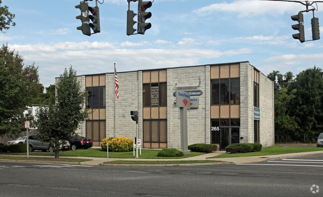
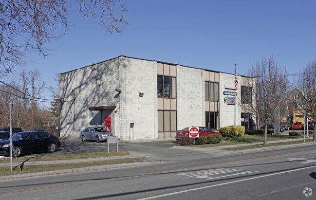
Property Record
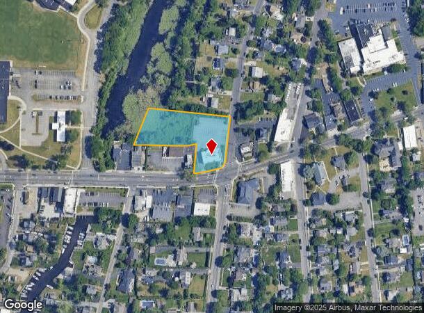
265 Main St, Islip, NY 11751

NEARBY LISTINGS FOR SALE OR LEASE
Property Detail
265 Main St
0500-370-00-01-00-021-001
Suffolk
Financialbuilding
New York
X
100
36103C0876H
1.54 AC
0
Southwestern Suffolk
2024
Long Island (New York)
200901
Nassau County-Suffolk County, NY
DEMOGRAPHICS near 265 Main St
1 Mile
3 Mile
5 Mile
2024 Total Population
11,467
86,173
202,473
2029 Population
11,333
84,052
196,833
Pop Growth 2024-2029
(1.17%)
(2.46%)
(2.79%)
Average Age
43
39
39
2024 Total Households
4,564
27,074
59,005
HH Growth 2024-2029
(1.27%)
(2.40%)
(2.78%)
Median Household Inc
$104,197
$114,416
$114,997
Avg Household Size
2.40
3.00
3.20
2024 Avg HH Vehicles
2.00
2.00
2.00
Median Home Value
$496,417
$451,064
$444,260
Median Year Built
1966
1964
1964
Nearby Places
Map Layers
Map Styles
 Street
 Aerial
- Restaurants
- Banks
- Shops
- Fitness
- Groceries
PUBLIC TRANSPORTATION
TRANSIT/SUBWAY
Islip Station (Montauk Branch - Long Island Rail Road)
DRIVE
WALK
Distance
Islip Station (Montauk Branch - Long Island Rail Road)
3 min
20 min
1.0 mi
COMMUTER RAIL
Islip Station (Montauk Branch - Long Island Rail Road)
DRIVE
WALK
Distance
Islip Station (Montauk Branch - Long Island Rail Road)
3 min
20 min
1.0 mi
Bay Shore Station (Montauk Branch - Long Island Rail Road)
DRIVE
WALK
Distance
Bay Shore Station (Montauk Branch - Long Island Rail Road)
5 min
2.1 mi
AIRPORT
Long Island MacArthur
DRIVE
WALK
Distance
Long Island MacArthur
18 min
10.2 mi
John F Kennedy International
DRIVE
WALK
Distance
John F Kennedy International
48 min
34.5 mi
LaGuardia
DRIVE
WALK
Distance
LaGuardia
58 min
41.4 mi
Freight Ports
NY - Red Hook Container Terminal
DRIVE
WALK
Distance
NY - Red Hook Container Terminal
69 min
45.9 mi
SALE & LEASE HISTORY
LISTING DATE
SALE/LEASE

Sep 25, 2016
For Lease
Nearby Properties
Address
Land Use
TOTAL SIZE
Lot Size
Zoning
Address
Land Use
TOTAL SIZE
Lot Size
Zoning
86.63 AC
Address
Land Use
TOTAL SIZE
Lot Size
Zoning
18.89 AC
Address
Land Use
TOTAL SIZE
Lot Size
Zoning
57.30 AC
IND1
Address
Land Use
TOTAL SIZE
Lot Size
Zoning
17.70 AC
A
Address
Land Use
TOTAL SIZE
Lot Size
Zoning
28.40 AC
A
Address
Land Use
TOTAL SIZE
Lot Size
Zoning
33.30 AC
A
Address
Land Use
TOTAL SIZE
Lot Size
Zoning
15 AC
B
Address
Land Use
TOTAL SIZE
Lot Size
Zoning
15.46 AC
PDDEC
Address
Land Use
TOTAL SIZE
Lot Size
Zoning
15.60 AC
BUS3
Address
Land Use
TOTAL SIZE
Lot Size
Zoning
19.86 AC
C
Address
Land Use
TOTAL SIZE
Lot Size
Zoning
19.60 AC
BUS3
Address
Land Use
TOTAL SIZE
Lot Size
Zoning
10.90 AC
B
Address
Land Use
TOTAL SIZE
Lot Size
Zoning
Address
Land Use
TOTAL SIZE
Lot Size
Zoning
19.04 AC
BUS1
Address
Land Use
TOTAL SIZE
Lot Size
Zoning
13.50 AC
AA
Address
Land Use
TOTAL SIZE
Lot Size
Zoning
66 AC
AAA
Address
Land Use
TOTAL SIZE
Lot Size
Zoning
11.05 AC
PDDOFF
Address
Land Use
TOTAL SIZE
Lot Size
Zoning
16 AC
PDDRI
Address
Land Use
TOTAL SIZE
Lot Size
Zoning
Address
Land Use
TOTAL SIZE
Lot Size
Zoning
9.70 AC
B
Address
Land Use
TOTAL SIZE
Lot Size
Zoning
46.60 AC
A
Address
Land Use
TOTAL SIZE
Lot Size
Zoning
7.70 AC
A
Address
Land Use
TOTAL SIZE
Lot Size
Zoning
10.38 AC
BUS1
Address
Land Use
TOTAL SIZE
Lot Size
Zoning
9.68 AC
PDDSC
Address
Land Use
TOTAL SIZE
Lot Size
Zoning
1.80 AC
Address
Land Use
TOTAL SIZE
Lot Size
Zoning
14.73 AC
A
Address
Land Use
TOTAL SIZE
Lot Size
Zoning
2.33 AC
DDD278
Address
Land Use
TOTAL SIZE
Lot Size
Zoning
45.47 AC
PDDEC
Address
Land Use
TOTAL SIZE
Lot Size
Zoning
3,898 SF
0.47 AC
R4
Address
Land Use
TOTAL SIZE
Lot Size
Zoning
10.25 AC
AAA
The World's #1 Commercial Real Estate Marketplace
Connect with us
© 2025 CoStar Group
The information above has been obtained from sources believed reliable. While we do not doubt its accuracy we have not verified it and make no guarantee, warranty or representation about it. It is your responsibility to independently confirm its accuracy and completeness. Any projections, opinions, assumptions, or estimates used are for example only and do not represent the current or future performance of the property. The value of this transaction to you depends on tax and other factors which should be evaluated by your tax, financial, and legal advisors. You and your advisors should conduct a careful, independent investigation of the property to determine to your satisfaction the suitability of the property for your needs.