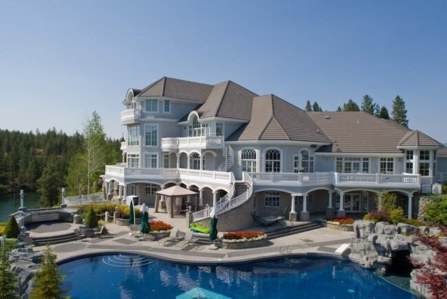
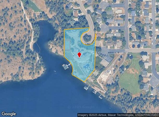
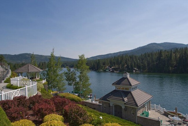
Property Record
216 S Parkwood Pl, Post Falls, ID 83854
NEARBY LISTINGS FOR SALE OR LEASE
Property Detail
216 S Parkwood Pl
Coeur d'Alene, ID
Parkwood Place Add
P6030001009A
Kootenai
Sfr
Idaho
AE
2.71 AC
16055C0383E
Post Falls
28,253 SF
Coeur D'Alene
DEMOGRAPHICS near 216 S Parkwood Pl
1 Mile
3 Mile
5 Mile
2024 Total Population
6,102
45,218
67,689
2029 Population
7,279
53,962
80,830
Pop Growth 2024-2029
+ 19.29%
+ 19.34%
+ 19.41%
Average Age
39
39
39
2024 Total Households
2,410
17,152
25,438
HH Growth 2024-2029
+ 19.00%
+ 18.98%
+ 19.07%
Median Household Inc
$61,961
$67,258
$68,606
Avg Household Size
2.50
2.60
2.60
2024 Avg HH Vehicles
2.00
2.00
2.00
Median Home Value
$391,784
$395,558
$428,402
Median Year Built
1988
2000
2002
Nearby Places
Map Layers
Map Styles
 Street
 Aerial
- Restaurants
- Banks
- Shops
- Fitness
- Groceries
PUBLIC TRANSPORTATION
AIRPORT
Spokane International
DRIVE
WALK
Distance
Spokane International
43 min
31.4 mi
Freight Ports
Port of Everett
DRIVE
WALK
Distance
Port of Everett
371 min
327.0 mi
SALE & LEASE HISTORY
LISTING DATE
SALE/LEASE

Sep 24, 2016
For Sale
Nearby Properties
Address
Land Use
TOTAL SIZE
Lot Size
Zoning
Address
Land Use
TOTAL SIZE
Lot Size
Zoning
135,646 SF
18.40 AC
Address
Land Use
TOTAL SIZE
Lot Size
Zoning
117,842 SF
13.36 AC
AG
Address
Land Use
TOTAL SIZE
Lot Size
Zoning
320,505 SF
60.51 AC
Address
Land Use
TOTAL SIZE
Lot Size
Zoning
89,184 SF
8.69 AC
Address
Land Use
TOTAL SIZE
Lot Size
Zoning
177,574 SF
8.44 AC
Address
Land Use
TOTAL SIZE
Lot Size
Zoning
88,780 SF
8.23 AC
Address
Land Use
TOTAL SIZE
Lot Size
Zoning
130,710 SF
8.23 AC
Address
Land Use
TOTAL SIZE
Lot Size
Zoning
42,636 SF
24.81 AC
Address
Land Use
TOTAL SIZE
Lot Size
Zoning
57,936 SF
7.88 AC
Address
Land Use
TOTAL SIZE
Lot Size
Zoning
465,080 SF
31.43 AC
Address
Land Use
TOTAL SIZE
Lot Size
Zoning
265,175 SF
13.74 AC
Address
Land Use
TOTAL SIZE
Lot Size
Zoning
59,629 SF
5.37 AC
Address
Land Use
TOTAL SIZE
Lot Size
Zoning
110,520 SF
4.68 AC
Address
Land Use
TOTAL SIZE
Lot Size
Zoning
112,154 SF
4.61 AC
Address
Land Use
TOTAL SIZE
Lot Size
Zoning
104,855 SF
4.71 AC
Address
Land Use
TOTAL SIZE
Lot Size
Zoning
94,193 SF
18.10 AC
AGSUB
Address
Land Use
TOTAL SIZE
Lot Size
Zoning
82,700 SF
21 AC
Address
Land Use
TOTAL SIZE
Lot Size
Zoning
672 SF
32.67 AC
RESRES
Address
Land Use
TOTAL SIZE
Lot Size
Zoning
192,335 SF
18.20 AC
Address
Land Use
TOTAL SIZE
Lot Size
Zoning
106,656 SF
4.60 AC
Address
Land Use
TOTAL SIZE
Lot Size
Zoning
63,432 SF
7.29 AC
Address
Land Use
TOTAL SIZE
Lot Size
Zoning
108,524 SF
20.34 AC
Address
Land Use
TOTAL SIZE
Lot Size
Zoning
24,698 SF
44.94 AC
Address
Land Use
TOTAL SIZE
Lot Size
Zoning
16,185 SF
60.19 AC
Address
Land Use
TOTAL SIZE
Lot Size
Zoning
59,039 SF
4.17 AC
Address
Land Use
TOTAL SIZE
Lot Size
Zoning
56,150 SF
1.56 AC
Address
Land Use
TOTAL SIZE
Lot Size
Zoning
61,536 SF
4.40 AC
Address
Land Use
TOTAL SIZE
Lot Size
Zoning
49,802 SF
9.86 AC
Address
Land Use
TOTAL SIZE
Lot Size
Zoning
67,104 SF
4.03 AC
Address
Land Use
TOTAL SIZE
Lot Size
Zoning
42,627 SF
3.15 AC
The World's #1 Commercial Real Estate Marketplace
Connect with us
© 2025 CoStar Group
The information above has been obtained from sources believed reliable. While we do not doubt its accuracy we have not verified it and make no guarantee, warranty or representation about it. It is your responsibility to independently confirm its accuracy and completeness. Any projections, opinions, assumptions, or estimates used are for example only and do not represent the current or future performance of the property. The value of this transaction to you depends on tax and other factors which should be evaluated by your tax, financial, and legal advisors. You and your advisors should conduct a careful, independent investigation of the property to determine to your satisfaction the suitability of the property for your needs.