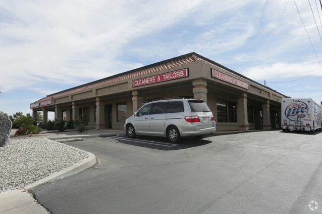
Property Record
12170 Spring Valley Pkwy, Victorville, CA 92395


NEARBY LISTINGS FOR SALE OR LEASE
Property Detail
12170 Spring Valley Pkwy
Riverside-San Bernardino-Ontario, CA
Tamarisk Tree Subdivision #2
0482-261-05
PARCEL MAP NO 424 PTN PARCEL 2 AND PTN LOT 16 TRACT NO 4158 TAMARISK TREE SUB DESC AS FOL BEG AT S 1/4 COR SEC 35 TP 5N R 4W BEING PT ON C/L BEAR VALLEY CUTOFF TH 0 DEG 51 MIN 04 SECONDS W 410 FT ALG E LI LOTS 15 & 16 TO TRUE POB TH S 89 DEG 14 MIN 3
Storebuilding
San Bernardino
X
California
06071C6485J
15
2024
0.84 AC
2025
Mojave River Valley
009913
Inland Empire (California)
10,000 SF
DEMOGRAPHICS near 12170 Spring Valley Pkwy
1 Mile
3 Mile
5 Mile
2024 Total Population
6,664
56,158
169,591
2029 Population
6,728
57,820
173,086
Pop Growth 2024-2029
+ 0.96%
+ 2.96%
+ 2.06%
Average Age
38
40
37
2024 Total Households
2,232
19,279
54,290
HH Growth 2024-2029
+ 0.90%
+ 2.95%
+ 2.09%
Median Household Inc
$70,472
$73,008
$61,151
Avg Household Size
2.90
2.90
3.10
2024 Avg HH Vehicles
2.00
2.00
2.00
Median Home Value
$366,244
$375,728
$345,860
Median Year Built
1985
1990
1985
Nearby Places
Map Layers
Map Styles
 Street
 Aerial
- Restaurants
- Banks
- Shops
- Fitness
- Groceries
PUBLIC TRANSPORTATION
COMMUTER RAIL
Victorville Amtrak (Southwest Chief - Amtrak)
DRIVE
WALK
Distance
Victorville Amtrak (Southwest Chief - Amtrak)
12 min
6.4 mi
Freight Ports
Port of Long Beach
DRIVE
WALK
Distance
Port of Long Beach
116 min
97.1 mi
Nearby Properties
Address
Land Use
TOTAL SIZE
Lot Size
Zoning
Address
Land Use
TOTAL SIZE
Lot Size
Zoning
828,388 SF
40.24 AC
Address
Land Use
TOTAL SIZE
Lot Size
Zoning
118,221 SF
22.58 AC
Address
Land Use
TOTAL SIZE
Lot Size
Zoning
650,650 SF
50.46 AC
Address
Land Use
TOTAL SIZE
Lot Size
Zoning
125,858 SF
9.70 AC
Address
Land Use
TOTAL SIZE
Lot Size
Zoning
275,018 SF
19.32 AC
Address
Land Use
TOTAL SIZE
Lot Size
Zoning
360,779 SF
28.92 AC
Address
Land Use
TOTAL SIZE
Lot Size
Zoning
232,416 SF
16.35 AC
Address
Land Use
TOTAL SIZE
Lot Size
Zoning
208,328 SF
16.94 AC
Address
Land Use
TOTAL SIZE
Lot Size
Zoning
138,191 SF
5.07 AC
Address
Land Use
TOTAL SIZE
Lot Size
Zoning
107,746 SF
9.99 AC
Address
Land Use
TOTAL SIZE
Lot Size
Zoning
97,008 SF
10.25 AC
Address
Land Use
TOTAL SIZE
Lot Size
Zoning
142,661 SF
14.21 AC
Address
Land Use
TOTAL SIZE
Lot Size
Zoning
324,161 SF
41.78 AC
Address
Land Use
TOTAL SIZE
Lot Size
Zoning
92,880 SF
6.98 AC
Address
Land Use
TOTAL SIZE
Lot Size
Zoning
84,623 SF
7.18 AC
Address
Land Use
TOTAL SIZE
Lot Size
Zoning
137,104 SF
12 AC
Address
Land Use
TOTAL SIZE
Lot Size
Zoning
65,440 SF
12.70 AC
Address
Land Use
TOTAL SIZE
Lot Size
Zoning
39,443 SF
7.21 AC
Address
Land Use
TOTAL SIZE
Lot Size
Zoning
102,120 SF
11.82 AC
Address
Land Use
TOTAL SIZE
Lot Size
Zoning
123,947 SF
8.80 AC
Address
Land Use
TOTAL SIZE
Lot Size
Zoning
42,082 SF
8.10 AC
Address
Land Use
TOTAL SIZE
Lot Size
Zoning
41,249 SF
4.84 AC
Address
Land Use
TOTAL SIZE
Lot Size
Zoning
36,151 SF
2.85 AC
Address
Land Use
TOTAL SIZE
Lot Size
Zoning
102,120 SF
11 AC
Address
Land Use
TOTAL SIZE
Lot Size
Zoning
71,920 SF
2.78 AC
Address
Land Use
TOTAL SIZE
Lot Size
Zoning
74.39 AC
Address
Land Use
TOTAL SIZE
Lot Size
Zoning
32,974 SF
2.54 AC
Address
Land Use
TOTAL SIZE
Lot Size
Zoning
18,800 SF
2.60 AC
Address
Land Use
TOTAL SIZE
Lot Size
Zoning
77,084 SF
6.83 AC
Address
Land Use
TOTAL SIZE
Lot Size
Zoning
48,984 SF
6.60 AC
The World's #1 Commercial Real Estate Marketplace
Connect with us
© 2025 CoStar Group
The information above has been obtained from sources believed reliable. While we do not doubt its accuracy we have not verified it and make no guarantee, warranty or representation about it. It is your responsibility to independently confirm its accuracy and completeness. Any projections, opinions, assumptions, or estimates used are for example only and do not represent the current or future performance of the property. The value of this transaction to you depends on tax and other factors which should be evaluated by your tax, financial, and legal advisors. You and your advisors should conduct a careful, independent investigation of the property to determine to your satisfaction the suitability of the property for your needs.