2030 Airport Rd
This feature is unavailable at the moment.
We apologize, but the feature you are trying to access is currently unavailable. We are aware of this issue and our team is working hard to resolve the matter.
Please check back in a few minutes. We apologize for the inconvenience.
- LoopNet Team
thank you

Your email has been sent!
2030 Airport Rd
25.44 Acres of Industrial Land Offered at $4,000,000 in Napa, CA 94558

EXECUTIVE SUMMARY
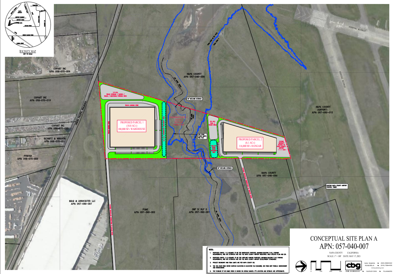
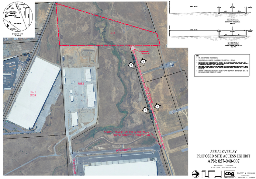
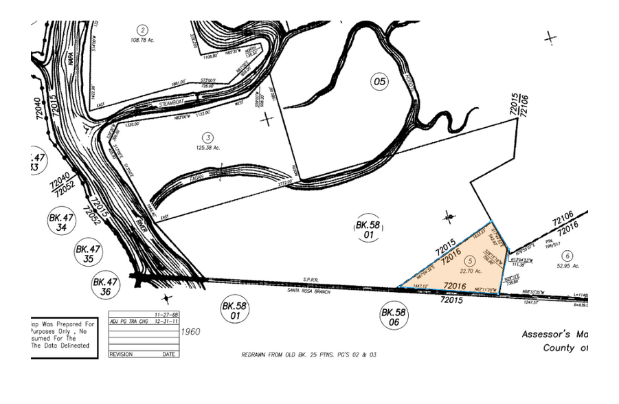
The property consists of 25.44 acres of undeveloped land, with the Napa County Airport located directly to the north and adjacent to it. To the west, it is adjacent to the newly built Napa Logistics Park. The property’s APN is 057-040-007 and is split by "No Name" Creek, which flows west into the Napa River. About six acres of the property are potentially wetlands and fall within the 100-year flood zone. These six acres have mostly been excluded from the development area. Please refer to the diagrams in Exhibit A for a better understanding of the property’s location.
Originally, the northern portion of the property was zoned as AC- Industrial: Airport Compatibility, and the southern portion was zoned as IP:AC - Planned Industrial: Airport Compatibility. After the 2008 General Plan Update, the northern section was rezoned to IP:AC. For more information, see Exhibit B, which includes excerpts from the "Napa County, Airport Industrial Area Specific Plan and EIR" and the Rezone Ordinance, Ordinance No. 1385.
Carlson, Barbee, and Gibson, a civil engineering firm, was hired to develop site plans for the property. Among the various site plans included in the due diligence materials, one plan outlines two potential building sites—one on the north side and one on the south side of the creek. The building envelope on the southern side is estimated to be 216,000 square feet, while the northern side has an estimated building envelope of 116,000 square feet. This site plan optimizes the buildable area by possibly placing the stormwater detention facilities within the 100-year flood plain.
PROPERTY FACTS
| Price | $4,000,000 | Property Type | Land |
| Sale Type | Investment | Property Subtype | Industrial |
| Sale Condition | Lease Option | Proposed Use | |
| No. Lots | 1 | Total Lot Size | 25.44 AC |
| Price | $4,000,000 |
| Sale Type | Investment |
| Sale Condition | Lease Option |
| No. Lots | 1 |
| Property Type | Land |
| Property Subtype | Industrial |
| Proposed Use | |
| Total Lot Size | 25.44 AC |
1 LOT AVAILABLE
Lot
| Price | $4,000,000 | Lot Size | 25.44 AC |
| Price Per AC | $157,232.70 |
| Price | $4,000,000 |
| Price Per AC | $157,232.70 |
| Lot Size | 25.44 AC |

PROPERTY TAXES
| Parcel Number | 057-040-007 | Improvements Assessment | $0 |
| Land Assessment | $2,732,726 | Total Assessment | $2,732,726 |
PROPERTY TAXES
Parcel Number
057-040-007
Land Assessment
$2,732,726
Improvements Assessment
$0
Total Assessment
$2,732,726
ZONING
| Zoning Code | GIAC (Rural mixed use) |
| GIAC (Rural mixed use) |

1 of 5
VIDEOS
3D TOUR
PHOTOS
STREET VIEW
STREET
MAP

Presented by
McHugh Commercial Real Estate
2030 Airport Rd
Already a member? Log In
Hmm, there seems to have been an error sending your message. Please try again.
Thanks! Your message was sent.