This feature is unavailable at the moment.
We apologize, but the feature you are trying to access is currently unavailable. We are aware of this issue and our team is working hard to resolve the matter.
Please check back in a few minutes. We apologize for the inconvenience.
- LoopNet Team
750 S State Rd
Cheshire, MA 01225
750-760 S State Road, Cheshire MA 01225 · For Lease

PROPERTY FACTS
| Property Type | Land | Proposed Use |
Retail
|
| Property Subtype | Commercial |
| Property Type | Land |
| Property Subtype | Commercial |
| Proposed Use |
Retail
|
Property Overview
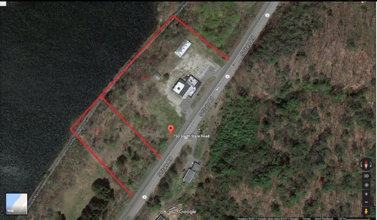
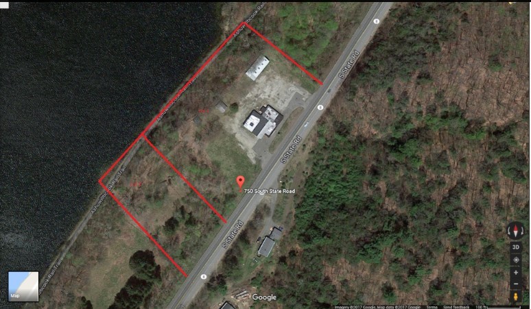
The former Country Charm located at 750-760 South State Rd is made-up of a lot that has been surveyed to include a 3.07 Acre parcel located on the northwest side of Route 8 in Cheshire, Massachusetts. The property overlooks the very popular running/biking/rollerblading/exercise Ashuwillticook Rail Trail and Cheshire Reservoir to the west. The currently developed area is approximately 1.7 Acres. The developed area gently slopes down from Route 8. The edges of the developed area steeply slope down to the surrounding area. Currently, there are two existing and recognized Massachusetts DOT approved curb cuts fifty feet wide that serve the site located along Route 8. The property currently has a single story wood frame 6,300 square foot restaurant building, two cottages with 600 and 350 square feet and a 1,300 square foot storage building which has a picnic pavilion attached. (all of or none of which will be removed per design requirements). A trail descends from the rear of the developed area to lot 102 as well as serves as access to and from the very popular rail trail. The site is served by overhead utility lines that run along the east side of Route 8. Water is supplied by a drilled well. There is currently a non adequate subsurface septic system (to be removed at the same time as the buildings will be razed.) The below and separate Lot 102 is to the southwest of the Country Charm lot and contains 1.39 acres. A steep hill drops down along the frontage of Route 8 to the level portion of the lot. A large portion of the lot is enclosed by a fence for a paddock. Remains of a small pole barn with a well and pump house are located in the rear of the lot. Access to lot 102 is currently along the trail from the rear of the Country Charm site. There is no existing curb cut along the frontage. A best case scenario would be to have the separated lot 102 used as a location for the public water supply (drilled well) after perc testing is completed in spring of 2017. A new septic system will be sized and installed in one of many possible locations based on the results of the perc tests to be completed in Spring of 2017. The location and design of the septic system will also comply with usage requirement of whatever business chooses to develop this location. Some site evaluations to consider: 1)What are the town and state requirements for a public water supply well? 2)Conduct a Title 5 inspection of the current septic system and/or perc tests to design a new system. for the Country Charm lot and perc test for lot 102. (being completed in spring 2017) 3)Create an access easement across the Country Charm site for lot 102 or investigate a curb cut for the lot and costs for constructing an access driveway. Any driveway to the usable part of the lot will have to descend 45 to 50 feet. 4)Wetland delineation for both lots. The 100' buffer zone for Cheshire Reservoir extends to the edge of the developed area. (being done in Spring 2017). Property Specifications for the site: Developable area: Approximately 1.7 acres – 74,052 sq feet Property Address: 750-760 South State Rd (Rt 8) Cheshire, MA 01225 Ownership: Fee Simple Land Located along the town of Cheshire’s North & Southbound primary thoroughfare with excellent visibility and over 13,900 vehicles passing by each day based on 2016 Mass DOT data. 3 current access points to the property -2 curb cuts along South State Rd. /Rt 8 -1 from the Ashuwillticook rail trail (walking access for upwards of 9,000 users per week in the warmer months per Department of Conservation & Recreation statistical data (2015) Traffic Counts: -South State Rd (State Highway 8) – 13,900 – 22,400 cars per day -Ashuwillticook Rail Trail – Walkers – 9,000 weekly users (Heaviest Traffic on weekend days) Parking: -Currently can be used to park over 100 vehicles at the site. 2016 Estimated Population: 1 Mile: 1,375 3 Mile: 3,182 5 Mile: 11,729 2016 Average Household Income: 1 Mile: $63,507 3 Mile: $71,638 5 Mile: $66,520 2016 Estimated Employees: 1 Mile: 445 3 Mile: 857 5 Mile: 4,275 Area Overview of Cheshire, MA Cheshire is a town in Berkshire County, MA United States that is part of the Pittsfield, MA Metropolitan Statistical Area. The population in the 2010 census was 3,235. Cheshire is located within the valley of the Hoosic River, and is the site of a dammed reservoir on the river which can be seen from this parcel. To, the west parts of Mount Greylock State Reservation take up sections of town, which includes a section of auto road. To the southeast, north mountain peaks just outside town limits before descending into the valley. Cheshire is joined with Adams to form a regional school district. The nearest community college is Berkshire Community College in Pittsfield. The nearest state college is Massachusetts College of Liberal Arts in North Adams and the nearest state university is Westfield State University and Umass – Amherst. Massachusetts Route 8 is the main thoroughfare through town, crossing from North to South. Route 116 also cuts through the northeast corner of town, and several sections provide panoramic views of Mt Greylock to the west. The town lies along one of the routes of the Berkshire Regional Transit Authority bus line. Regional service can be found in both North Adams and Pittsfield, as can regional air service. The nearest airport with national/international service is Albany International Airport. Berkshire County, is a county located on the western edge of U.S. state of Massachusetts. As of the 2015 census the population of Berkshire County was 127,828. It largest city and traditional county seat is Pittsfield. The county was founded in 1761. Berkshire County is one of two Massachusetts counties that border three neighboring states; the other being Worcester county. The two counties are also the only ones to touch both the northern and southern state lines. County-wide bus service is provided by the Berkshire Regional Transit Authority. Amtrak service is provided at Pittsfield. The nearest major international airport is Albany, New York at 48 miles from the center of Berkshire county, MA.
Listing ID: 11424922
Date on Market: 1/31/2018
Last Updated:
Address: 750 S State Rd, Cheshire, MA 01225

