This feature is unavailable at the moment.
We apologize, but the feature you are trying to access is currently unavailable. We are aware of this issue and our team is working hard to resolve the matter.
Please check back in a few minutes. We apologize for the inconvenience.
- LoopNet Team
thank you

Your email has been sent!
E Sheridan Ave
1.66 Acres of Commercial Land Offered at $2,165,000 in Oklahoma City, OK 73104


INVESTMENT HIGHLIGHTS
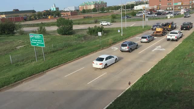
- Located in the Bricktown Business District
- Downtown Entertainment Area
- Near the Oklahoma City Dodgers Baseball Field
EXECUTIVE SUMMARY
The Oklahoma Department of Transportation has set the minimum bid requirement at $2,165,000.00 for this sale. The parcel is being sold “as is-where is”, with the buyer being responsible for their own due diligence in regards to zoning, licenses, permits, environmental, land uses, etc.
Terms of the sale are ten percent (10%) of the bid price in non-refundable certified funds and must accompany each bid in the form of a bid deposit. The balance of the bid will be due in certified funds within thirty (30) calendar days after the approval by the Oklahoma Transportation Commission. Deposits submitted by non-successful bidders will be returned. The successful high bidder will also be required to pay for any and all advertising costs associated with the sale of this land. After approval of the sale, an executed and recorded Quitclaim Deed will be mailed to the highest bidder. IMPORTANT: LABEL THE OUTSIDE OF THE ENVELOPE WITH “SEALED BID”.
All sales of surplus lands, or interests therein, is subject to the confirmation of the Oklahoma Transportation Commission. The Oklahoma Transportation Commission reserves the right to reject any and all bids.
All inquiries should be made to Frank Roesler III, Transportation Manager, Facilities Management Division, 200 N.E. 21st Street, Oklahoma City, Oklahoma 73105, or by calling (405) 522-5659
PROPERTY FACTS
| Price | $2,165,000 | Proposed Use | Commercial |
| Sale Type | Investment or Owner User | Total Lot Size | 1.66 AC |
| No. Lots | 1 | Cross Streets | S LINCOLN BLVD |
| Property Type | Land | Opportunity Zone |
Yes
|
| Property Subtype | Commercial |
| Price | $2,165,000 |
| Sale Type | Investment or Owner User |
| No. Lots | 1 |
| Property Type | Land |
| Property Subtype | Commercial |
| Proposed Use | Commercial |
| Total Lot Size | 1.66 AC |
| Cross Streets | S LINCOLN BLVD |
| Opportunity Zone |
Yes |
1 LOT AVAILABLE
Lot
| Price | $2,165,000 | Lot Size | 1.66 AC |
| Price Per AC | $1,304,216.87 |
| Price | $2,165,000 |
| Price Per AC | $1,304,216.87 |
| Lot Size | 1.66 AC |
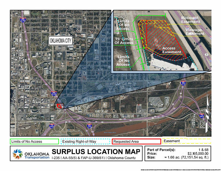
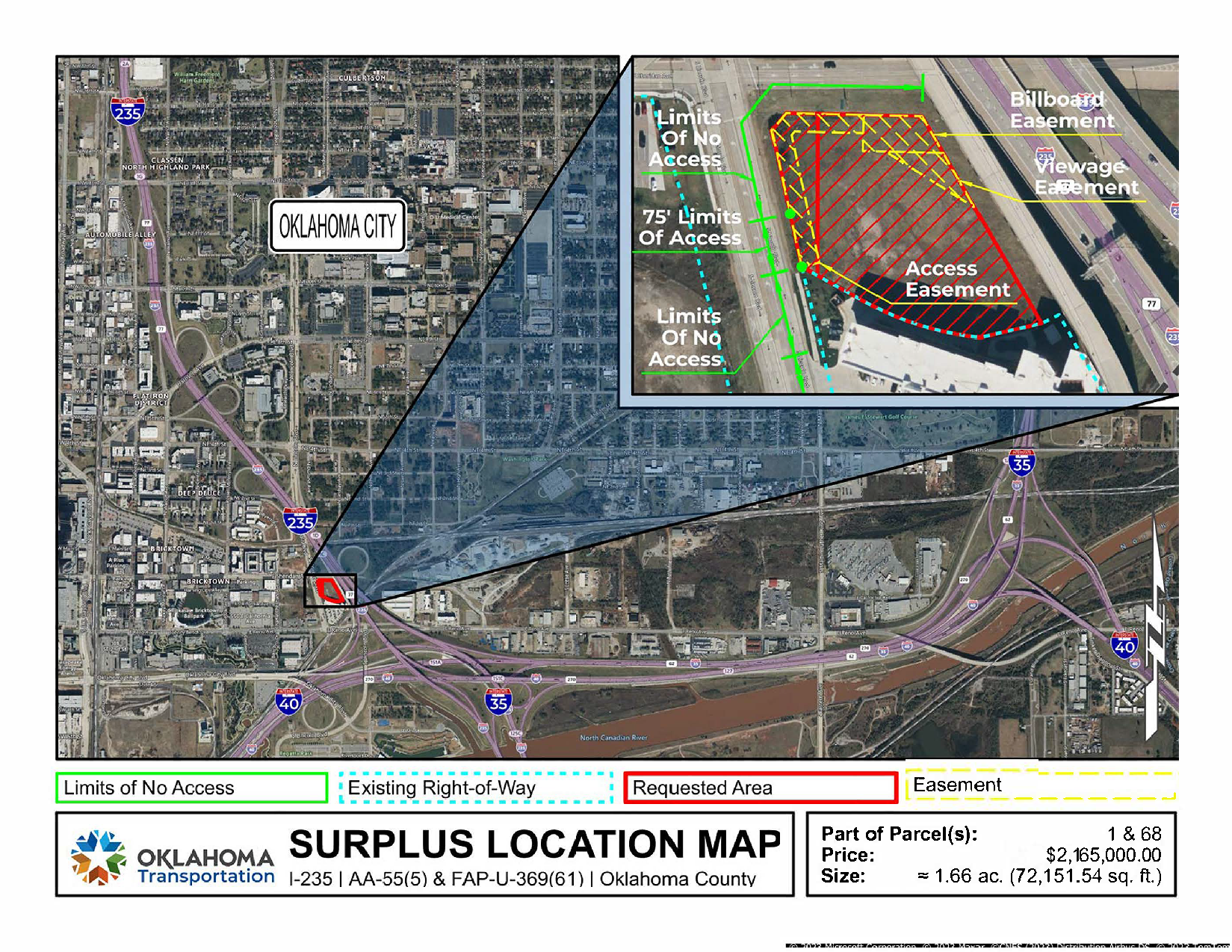
A strip, piece or parcel of land lying in part of the SW¼ SE¼ of Section 34, T12N, R3W in Oklahoma County, Oklahoma. Containing 72100.23 sq. ft. or 1.66 acres, more or less.
DESCRIPTION
A strip, piece or parcel of land lying in part of the SW¼ SE¼ of Section 34, T12N, R3W in Oklahoma County, Oklahoma. Said parcel of land being described by metes and bounds as follows: Commencing at the SW Corner of the SW¼ SE¼, thence N89°24’35”E a distance of 959.41 feet, thence N00°35’28”W a distance of 412.94 feet to a point on the permanent Westerly right-of-way line of Interstate Highway No. 235, thence N31°30’15”W along said right-of-way line a distance of 20.00 feet to the POINT OF BEGINNING, thence continuing N31°30’15”W along said right-of-way line a distance of 329.93 feet to a point on the present South right-of-way line of East Sheridan Avenue, thence S89°49’46”W along said right-of-way line a distance of 187.35 feet, thence S37°59’10”W along said right-of-way line a distance of 30.89 feet to a point on the present East right-of-way line of North Lincoln Boulevard, thence S13°51’26”E along said right-of-way line a distance of 192.62 feet, thence S62°30’02.50”E a distance of 99.71 feet, thence Southeasterly on a curve to the left having a chord bearing of S74°21’59.15”E and a radius of 409.28 feet an arc distance of 167.68 feet, thence N75°36’02.79”E a distance of 86.57 feet to said POINT OF BEGINNING. Containing 72100.23 sq. ft. or 1.66 acres, more or less. Grantor, reserves and excepts unto itself, its successors and assigns ALL EXISTING RIGHTS OF ACCESS from said 1.66 acres, more or less to the lands or rights-of-way covered by the abutting Interstate Highway No. 235 Limited Access Highway facility on the Easterly side, East Sheridan Avenue facility on the North side, and North Lincoln Boulevard Facility on the Westerly side, except that, Grantee, their successors and assigns shall have the right of access to the North Lincoln Boulevard facility, Commencing at the SW Corner of the SW¼ SE¼, thence N89°24’35”E a distance of 959.41 feet, thence N00°35’28”W a distance of 412.94 feet to a point on the permanent Westerly right-of-way line of Interstate Highway No. 235, thence N31°30’15”W along said right-of-way line a distance of 20.00 feet to the point of beginning, thence continuing N31°30’15”W along said right-of-way line a distance of 329.93 feet to a point on the present South right-of-way line of East Sheridan Avenue, thence S89°49’46”W along said right-of-way line a distance of 187.35 feet, thence S37°59’10”W along said right-of-way line a distance of 30.89 feet to a point on the present East right-of-way line of North Lincoln Boulevard, thence S13°51’26”E along said right-of-way line a distance of 117.62 feet to the POINT OF BEGINNING, thence S13°51’26”E along said right-of-way a distance of 75.00 feet to the POINT OF ENDING.
ZONING
| Zoning Code | CBD (Central Business District What Is Accessibility Testing? Accessibility testing is the practice of making your web and mobile apps usab) |
| CBD (Central Business District What Is Accessibility Testing? Accessibility testing is the practice of making your web and mobile apps usab) |
Presented by

E Sheridan Ave
Hmm, there seems to have been an error sending your message. Please try again.
Thanks! Your message was sent.


