Property Record
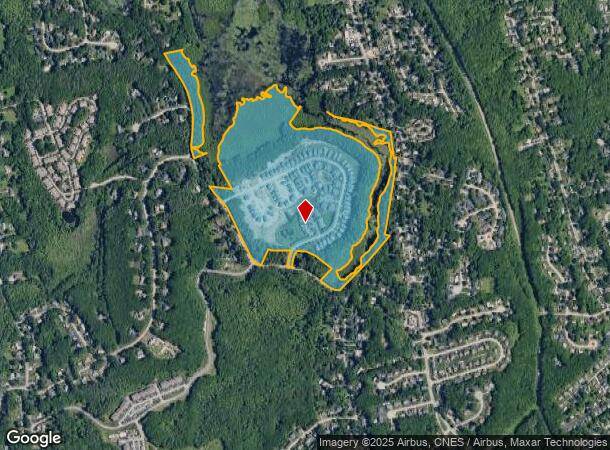
42 Tea Party Cir, Holden, MA 01520
This Property Is For Sale
NEARBY LISTINGS FOR SALE OR LEASE
-
-
No Photo
-
-
-
View all Holden listings for sale on LoopNet.com
Property Detail
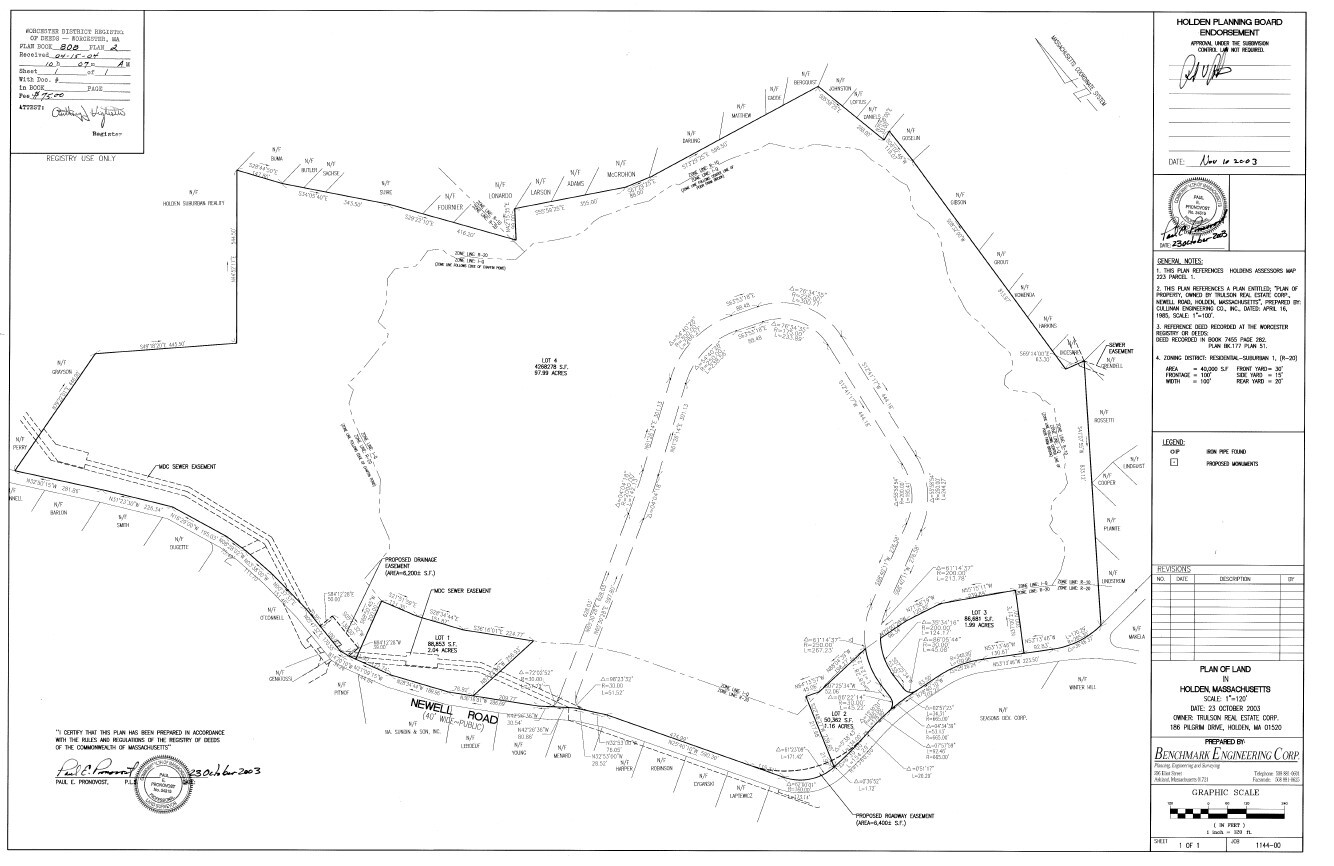
42 Tea Party Cir
HOLD-000223-000000-000517
Worcester
Condominium
Massachusetts
ARE
Outlying Worcester
25027C0605E
Boston
1,872 SF
Worcester, MA-CT
DEMOGRAPHICS near 42 Tea Party Cir
1 Mile
3 Mile
5 Mile
2024 Total Population
5,635
47,179
146,572
2029 Population
5,677
46,674
144,153
Pop Growth 2024-2029
+ 0.75%
(1.07%)
(1.65%)
Average Age
43
42
39
2024 Total Households
2,123
17,838
56,330
HH Growth 2024-2029
+ 0.75%
(1.17%)
(1.66%)
Median Household Inc
$127,956
$102,343
$68,608
Avg Household Size
2.60
2.50
2.40
2024 Avg HH Vehicles
2.00
2.00
2.00
Median Home Value
$444,321
$366,852
$345,143
Median Year Built
1981
1958
1954
Nearby Places
- Restaurants
- Banks
- Shops
- Fitness
- Groceries
PUBLIC TRANSPORTATION
COMMUTER RAIL
Worcester Union Station (Lake Shore Limited - Amtrak)
DRIVE
WALK
Distance
Worcester Union Station (Lake Shore Limited - Amtrak)
12 min
5.3 mi
Worcester (Framingham/Worcester Line - Massachusetts Bay Transportation Authority Commuter Rail (Purple Line))
DRIVE
WALK
Distance
Worcester (Framingham/Worcester Line - Massachusetts Bay Transportation Authority Commuter Rail (Purple Line))
12 min
5.5 mi
AIRPORT
Worcester Regional
DRIVE
WALK
Distance
Worcester Regional
18 min
7.0 mi
Freight Ports
Port of Boston
DRIVE
WALK
Distance
Port of Boston
73 min
50.3 mi
Nearby Properties
Address
Land Use
TOTAL SIZE
Lot Size
Zoning
Address
Land Use
TOTAL SIZE
Lot Size
Zoning
50.11 AC
RS-7
Address
Land Use
TOTAL SIZE
Lot Size
Zoning
16,404 SF
10.80 AC
RS-10
Address
Land Use
TOTAL SIZE
Lot Size
Zoning
126,849 SF
15.18 AC
R15
Address
Land Use
TOTAL SIZE
Lot Size
Zoning
44,584 SF
90.22 AC
Address
Land Use
TOTAL SIZE
Lot Size
Zoning
291,410 SF
21.73 AC
RL-7
Address
Land Use
TOTAL SIZE
Lot Size
Zoning
199,870 SF
90.11 AC
R10
Address
Land Use
TOTAL SIZE
Lot Size
Zoning
120,732 SF
28.92 AC
RS-10
Address
Land Use
TOTAL SIZE
Lot Size
Zoning
153,482 SF
5.95 AC
MG-1
Address
Land Use
TOTAL SIZE
Lot Size
Zoning
741.61 AC
R40
Address
Land Use
TOTAL SIZE
Lot Size
Zoning
137,290 SF
10.51 AC
RS-7
Address
Land Use
TOTAL SIZE
Lot Size
Zoning
121,504 SF
3.75 AC
BG-3
Address
Land Use
TOTAL SIZE
Lot Size
Zoning
29.20 AC
RS-7
Address
Land Use
TOTAL SIZE
Lot Size
Zoning
145,068 SF
16.35 AC
BG-3
Address
Land Use
TOTAL SIZE
Lot Size
Zoning
83,889 SF
12.47 AC
R20
Address
Land Use
TOTAL SIZE
Lot Size
Zoning
77,273 SF
20.79 AC
R15
Address
Land Use
TOTAL SIZE
Lot Size
Zoning
96,541 SF
5.24 AC
MG-5
Address
Land Use
TOTAL SIZE
Lot Size
Zoning
13 AC
RS-7
Address
Land Use
TOTAL SIZE
Lot Size
Zoning
99,584 SF
5.72 AC
RS-7
Address
Land Use
TOTAL SIZE
Lot Size
Zoning
16.60 AC
MG-1
Address
Land Use
TOTAL SIZE
Lot Size
Zoning
564,103 SF
28.43 AC
MG-1
Address
Land Use
TOTAL SIZE
Lot Size
Zoning
102,049 SF
11.46 AC
RS-10
Address
Land Use
TOTAL SIZE
Lot Size
Zoning
9.98 AC
MG-1
Address
Land Use
TOTAL SIZE
Lot Size
Zoning
260,043 SF
15.23 AC
MG-1
Address
Land Use
TOTAL SIZE
Lot Size
Zoning
110,923 SF
17.69 AC
BG-3
Address
Land Use
TOTAL SIZE
Lot Size
Zoning
243,503 SF
10.07 AC
MG-2
Address
Land Use
TOTAL SIZE
Lot Size
Zoning
16.22 AC
RS-7
Address
Land Use
TOTAL SIZE
Lot Size
Zoning
38.90 AC
RS-7
Address
Land Use
TOTAL SIZE
Lot Size
Zoning
59,178 SF
10.06 AC
R10
Address
Land Use
TOTAL SIZE
Lot Size
Zoning
118,532 SF
11.44 AC
MG-2
Address
Land Use
TOTAL SIZE
Lot Size
Zoning
34.79 AC
MG-1
The World's #1 Commercial Real Estate Marketplace
Connect with us
© 2025 CoStar Group
The information above has been obtained from sources believed reliable. While we do not doubt its accuracy we have not verified it and make no guarantee, warranty or representation about it. It is your responsibility to independently confirm its accuracy and completeness. Any projections, opinions, assumptions, or estimates used are for example only and do not represent the current or future performance of the property. The value of this transaction to you depends on tax and other factors which should be evaluated by your tax, financial, and legal advisors. You and your advisors should conduct a careful, independent investigation of the property to determine to your satisfaction the suitability of the property for your needs.