Property Record
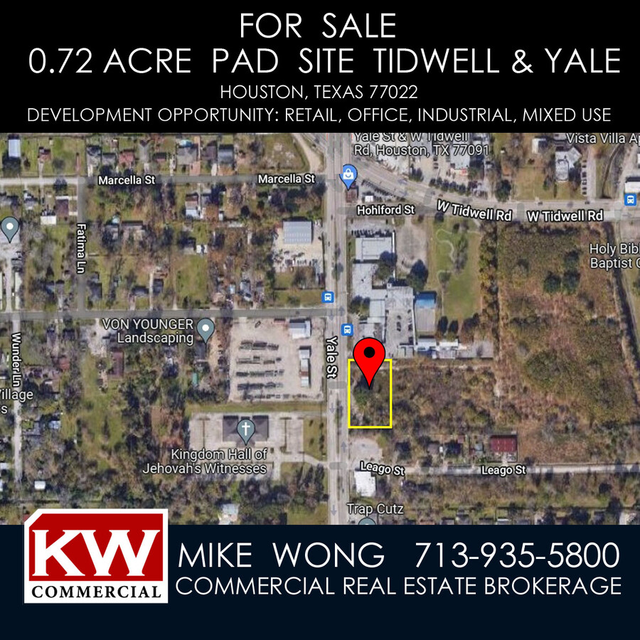
0 Yale St, Houston, TX 77091

This Property Is For Sale
NEARBY LISTINGS FOR SALE OR LEASE
Property Detail
0 Yale St
Houston-The Woodlands-Sugar Land, TX
Hohl Apts
1248630010002
RES B BLK 1 (EDUCATIONAL & INSTITUTIONAL) HOHL APTS
Commercialacreage
Harris
X
Texas
48201C0660M
0.73 AC
2023
Northeast Near
2023
Houston
531800
DEMOGRAPHICS near 0 Yale St
1 Mile
3 Mile
5 Mile
2024 Total Population
18,644
135,378
369,136
2029 Population
19,420
139,489
379,829
Pop Growth 2024-2029
+ 4.16%
+ 3.04%
+ 2.90%
Average Age
37
37
36
2024 Total Households
6,720
48,888
137,126
HH Growth 2024-2029
+ 4.30%
+ 3.23%
+ 3.14%
Median Household Inc
$34,414
$55,017
$57,740
Avg Household Size
2.70
2.70
2.60
2024 Avg HH Vehicles
2.00
2.00
2.00
Median Home Value
$194,960
$318,469
$294,371
Median Year Built
1967
1968
1975
Nearby Places
- Restaurants
- Banks
- Shops
- Fitness
- Groceries
PUBLIC TRANSPORTATION
COMMUTER RAIL
Houston (Sunset Limited - Amtrak)
DRIVE
WALK
Distance
Houston (Sunset Limited - Amtrak)
17 min
9.6 mi
AIRPORT
George Bush Intcntl/Houston
DRIVE
WALK
Distance
George Bush Intcntl/Houston
24 min
15.3 mi
William P Hobby
DRIVE
WALK
Distance
William P Hobby
37 min
22.4 mi
Freight Ports
Port of Houston
DRIVE
WALK
Distance
Port of Houston
29 min
18.0 mi
Nearby Properties
Address
Land Use
TOTAL SIZE
Lot Size
Zoning
Address
Land Use
TOTAL SIZE
Lot Size
Zoning
350,655 SF
16.76 AC
Address
Land Use
TOTAL SIZE
Lot Size
Zoning
668,880 SF
43.68 AC
Address
Land Use
TOTAL SIZE
Lot Size
Zoning
308,168 SF
21.34 AC
Address
Land Use
TOTAL SIZE
Lot Size
Zoning
228,804 SF
3.28 AC
Address
Land Use
TOTAL SIZE
Lot Size
Zoning
444,798 SF
17.16 AC
Address
Land Use
TOTAL SIZE
Lot Size
Zoning
336,050 SF
14.41 AC
Address
Land Use
TOTAL SIZE
Lot Size
Zoning
279,452 SF
5.69 AC
Address
Land Use
TOTAL SIZE
Lot Size
Zoning
145,132 SF
3.69 AC
Address
Land Use
TOTAL SIZE
Lot Size
Zoning
244,727 SF
10.49 AC
Address
Land Use
TOTAL SIZE
Lot Size
Zoning
313,158 SF
12.54 AC
Address
Land Use
TOTAL SIZE
Lot Size
Zoning
200,233 SF
8.14 AC
Address
Land Use
TOTAL SIZE
Lot Size
Zoning
333,616 SF
12.80 AC
Address
Land Use
TOTAL SIZE
Lot Size
Zoning
531,786 SF
17.60 AC
Address
Land Use
TOTAL SIZE
Lot Size
Zoning
264,996 SF
18.94 AC
Address
Land Use
TOTAL SIZE
Lot Size
Zoning
333,286 SF
13.95 AC
Address
Land Use
TOTAL SIZE
Lot Size
Zoning
437,052 SF
15.90 AC
Address
Land Use
TOTAL SIZE
Lot Size
Zoning
432,691 SF
3.26 AC
Address
Land Use
TOTAL SIZE
Lot Size
Zoning
43.68 AC
Address
Land Use
TOTAL SIZE
Lot Size
Zoning
172,439 SF
6.70 AC
Address
Land Use
TOTAL SIZE
Lot Size
Zoning
176,505 SF
2.72 AC
Address
Land Use
TOTAL SIZE
Lot Size
Zoning
200,511 SF
9.48 AC
Address
Land Use
TOTAL SIZE
Lot Size
Zoning
239,058 SF
9.76 AC
Address
Land Use
TOTAL SIZE
Lot Size
Zoning
131,494 SF
5 AC
Address
Land Use
TOTAL SIZE
Lot Size
Zoning
170,724 SF
14.59 AC
Address
Land Use
TOTAL SIZE
Lot Size
Zoning
239,721 SF
8.98 AC
Address
Land Use
TOTAL SIZE
Lot Size
Zoning
265,572 SF
20.64 AC
Address
Land Use
TOTAL SIZE
Lot Size
Zoning
286,558 SF
11.45 AC
Address
Land Use
TOTAL SIZE
Lot Size
Zoning
283,375 SF
13 AC
Address
Land Use
TOTAL SIZE
Lot Size
Zoning
328,951 SF
11.92 AC
Address
Land Use
TOTAL SIZE
Lot Size
Zoning
169,267 SF
6.09 AC
The World's #1 Commercial Real Estate Marketplace
Connect with us
© 2025 CoStar Group
The information above has been obtained from sources believed reliable. While we do not doubt its accuracy we have not verified it and make no guarantee, warranty or representation about it. It is your responsibility to independently confirm its accuracy and completeness. Any projections, opinions, assumptions, or estimates used are for example only and do not represent the current or future performance of the property. The value of this transaction to you depends on tax and other factors which should be evaluated by your tax, financial, and legal advisors. You and your advisors should conduct a careful, independent investigation of the property to determine to your satisfaction the suitability of the property for your needs.