Property Record
1075 R P C Rd, Fort Mill, SC 29708
This Property Is For Sale
NEARBY LISTINGS FOR SALE OR LEASE
Property Detail
1075 R P C Rd
Charlotte-Concord-Gastonia, NC-SC
Mh
6550000058
OFF HWY 160
Commercialacreage
York
X
South Carolina
45091C0212F
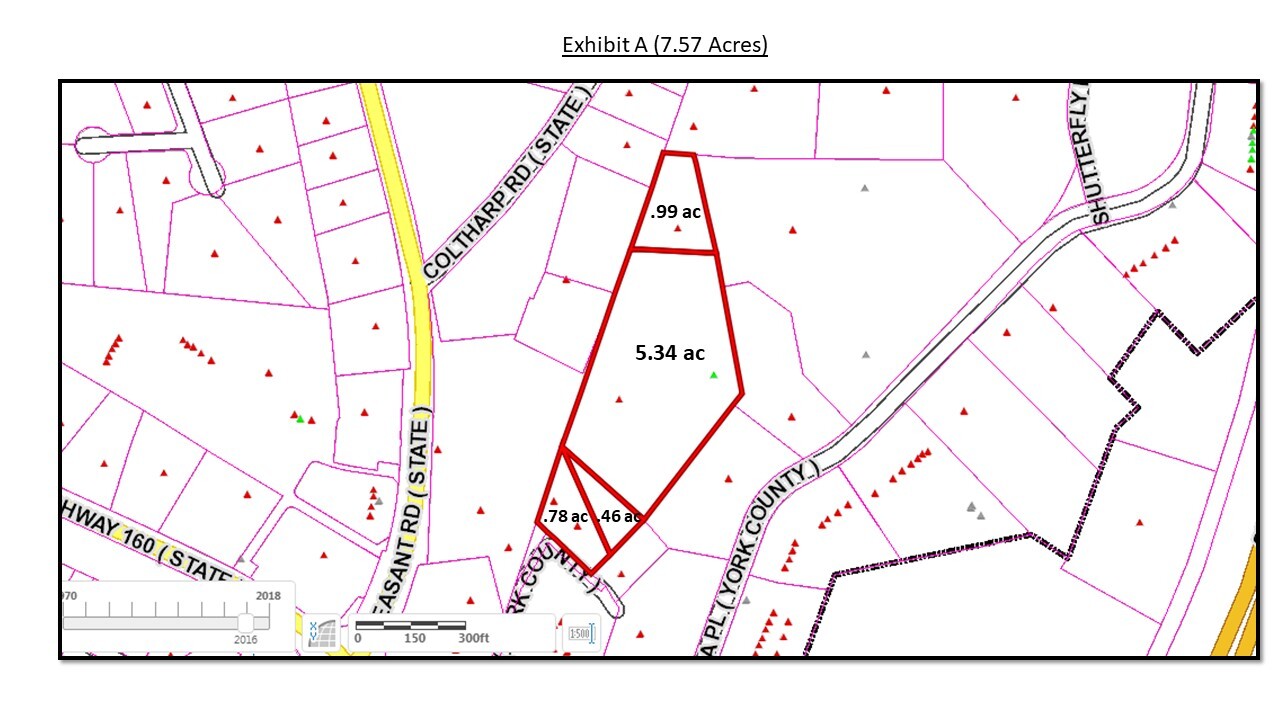
0.99 AC
2024
York County
2024
Charlotte
061011
DEMOGRAPHICS near 1075 R P C Rd
1 Mile
3 Mile
5 Mile
2024 Total Population
6,274
48,887
128,050
2029 Population
7,156
55,283
143,977
Pop Growth 2024-2029
+ 14.06%
+ 13.08%
+ 12.44%
Average Age
37
38
38
2024 Total Households
2,295
18,363
48,039
HH Growth 2024-2029
+ 14.29%
+ 13.40%
+ 12.66%
Median Household Inc
$117,657
$105,907
$102,865
Avg Household Size
2.70
2.60
2.60
2024 Avg HH Vehicles
2.00
2.00
2.00
Median Home Value
$461,565
$405,145
$372,034
Median Year Built
2010
2006
2005
Nearby Places
- Restaurants
- Banks
- Shops
- Fitness
- Groceries
PUBLIC TRANSPORTATION
AIRPORT
Charlotte/Douglas International
DRIVE
WALK
Distance
Charlotte/Douglas International
29 min
15.9 mi
Concord-Padgett Regional
DRIVE
WALK
Distance
Concord-Padgett Regional
47 min
32.9 mi
Freight Ports
North Charleston Terminal
DRIVE
WALK
Distance
North Charleston Terminal
207 min
184.0 mi
Nearby Properties
Address
Land Use
TOTAL SIZE
Lot Size
Zoning
Address
Land Use
TOTAL SIZE
Lot Size
Zoning
151,844 SF
11.65 AC
Address
Land Use
TOTAL SIZE
Lot Size
Zoning
401.79 AC
Address
Land Use
TOTAL SIZE
Lot Size
Zoning
335.85 AC
AGC
Address
Land Use
TOTAL SIZE
Lot Size
Zoning
790,440 SF
53.19 AC
Address
Land Use
TOTAL SIZE
Lot Size
Zoning
178,585 SF
17.44 AC
Address
Land Use
TOTAL SIZE
Lot Size
Zoning
2,476 SF
88.14 AC
Address
Land Use
TOTAL SIZE
Lot Size
Zoning
100 AC
RDI
Address
Land Use
TOTAL SIZE
Lot Size
Zoning
162.78 AC
RCI
Address
Land Use
TOTAL SIZE
Lot Size
Zoning
197,864 SF
39.37 AC
Address
Land Use
TOTAL SIZE
Lot Size
Zoning
11,056 SF
1.89 AC
RDI
Address
Land Use
TOTAL SIZE
Lot Size
Zoning
7,772 SF
4.75 AC
Address
Land Use
TOTAL SIZE
Lot Size
Zoning
38,954 SF
21.27 AC
BDIII
Address
Land Use
TOTAL SIZE
Lot Size
Zoning
Address
Land Use
TOTAL SIZE
Lot Size
Zoning
26,733 SF
34.66 AC
PD
Address
Land Use
TOTAL SIZE
Lot Size
Zoning
81,700 SF
43.75 AC
Address
Land Use
TOTAL SIZE
Lot Size
Zoning
25,554 SF
14.18 AC
PD
Address
Land Use
TOTAL SIZE
Lot Size
Zoning
17,304 SF
3.30 AC
BDII
Address
Land Use
TOTAL SIZE
Lot Size
Zoning
131,716 SF
13.89 AC
Address
Land Use
TOTAL SIZE
Lot Size
Zoning
45.75 AC
RDI
Address
Land Use
TOTAL SIZE
Lot Size
Zoning
155,948 SF
17.02 AC
UD
Address
Land Use
TOTAL SIZE
Lot Size
Zoning
33,780 SF
14.39 AC
BDIII
Address
Land Use
TOTAL SIZE
Lot Size
Zoning
250,903 SF
16.52 AC
BDII
Address
Land Use
TOTAL SIZE
Lot Size
Zoning
48,912 SF
14.66 AC
Address
Land Use
TOTAL SIZE
Lot Size
Zoning
27,436 SF
16.85 AC
BDI
Address
Land Use
TOTAL SIZE
Lot Size
Zoning
10.57 AC
Address
Land Use
TOTAL SIZE
Lot Size
Zoning
32,564 SF
13.44 AC
PD
Address
Land Use
TOTAL SIZE
Lot Size
Zoning
280,000 SF
35.63 AC
ID
Address
Land Use
TOTAL SIZE
Lot Size
Zoning
39,312 SF
13.11 AC
Address
Land Use
TOTAL SIZE
Lot Size
Zoning
27,372 SF
9.79 AC
BDIII
Address
Land Use
TOTAL SIZE
Lot Size
Zoning
147,092 SF
10.63 AC
The World's #1 Commercial Real Estate Marketplace
Connect with us
© 2025 CoStar Group
The information above has been obtained from sources believed reliable. While we do not doubt its accuracy we have not verified it and make no guarantee, warranty or representation about it. It is your responsibility to independently confirm its accuracy and completeness. Any projections, opinions, assumptions, or estimates used are for example only and do not represent the current or future performance of the property. The value of this transaction to you depends on tax and other factors which should be evaluated by your tax, financial, and legal advisors. You and your advisors should conduct a careful, independent investigation of the property to determine to your satisfaction the suitability of the property for your needs.