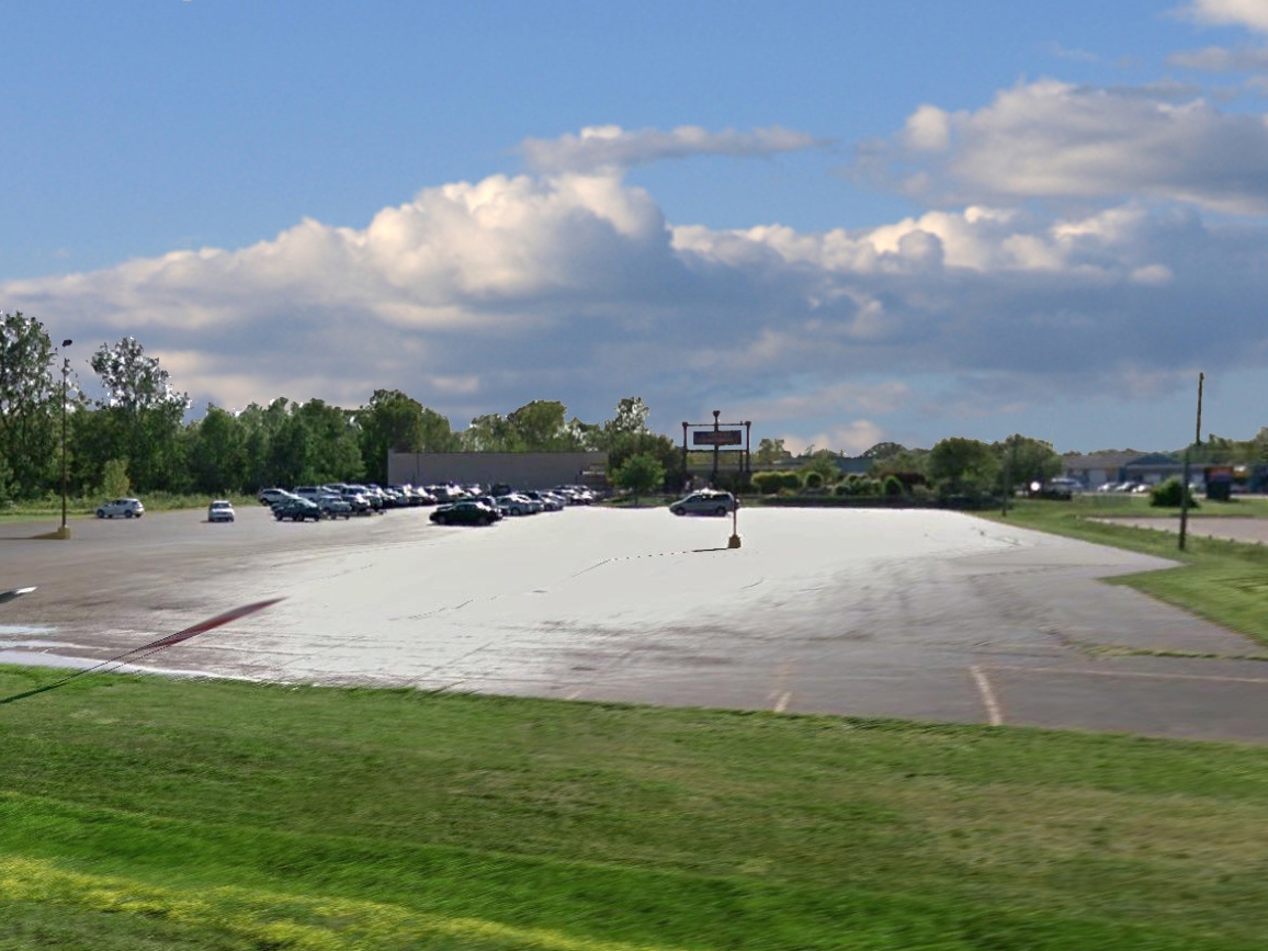
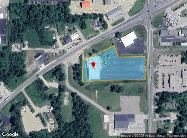
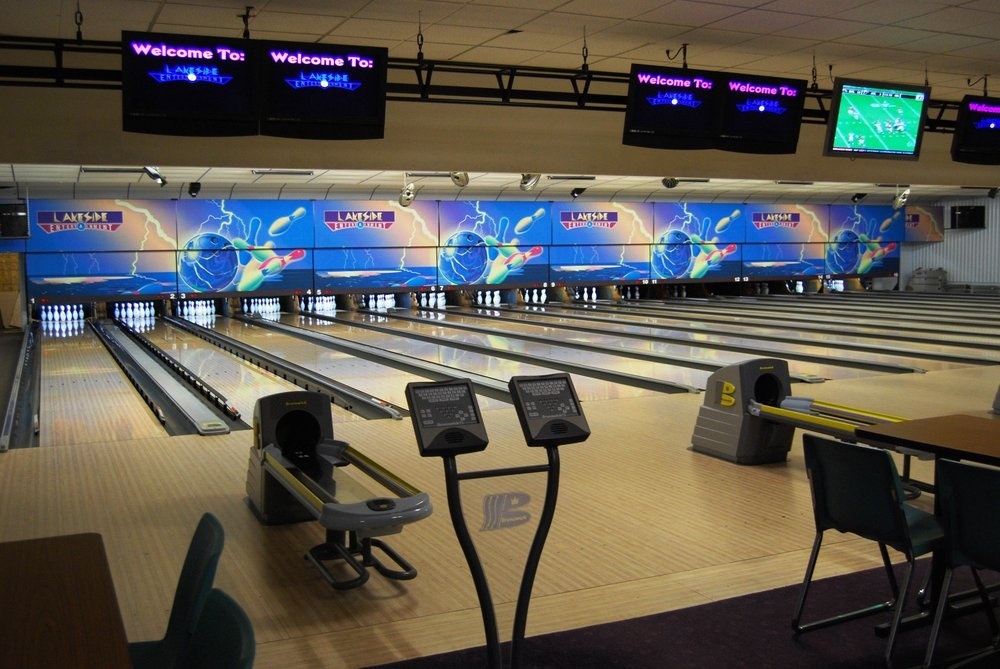
Property Record
09921 Blue Star Memorial Hwy, South Haven, MI 49090
NEARBY LISTINGS FOR SALE OR LEASE
Property Detail
09921 Blue Star Memorial Hwy
80-17-015-091-00
231-C 15-1-17 762-429 1048-468,469 * BEG ON 1/8 L 50' S 0 DEG 02' 38" E FROM 1/8 POST ON N SIDE OF SE 1/4 OF SEC, TH S 0 DEG
Bowlingalley
Van Buren
X
Michigan
26159C0019D
3.40 AC
2024
Van Buren County
2024
West Michigan
010500
Kalamazoo-Portage, MI
24,315 SF
DEMOGRAPHICS near 09921 Blue Star Memorial Hwy
1 Mile
3 Mile
5 Mile
2024 Total Population
1,828
10,087
13,441
2029 Population
1,890
10,517
13,902
Pop Growth 2024-2029
+ 3.39%
+ 4.26%
+ 3.43%
Average Age
45
47
46
2024 Total Households
809
4,686
6,013
HH Growth 2024-2029
+ 3.34%
+ 4.74%
+ 3.92%
Median Household Inc
$50,806
$51,661
$54,054
Avg Household Size
2.20
2.10
2.20
2024 Avg HH Vehicles
2.00
2.00
2.00
Median Home Value
$278,204
$290,831
$267,220
Median Year Built
1964
1971
1974
Nearby Places
- Restaurants
- Banks
- Shops
- Fitness
- Groceries
SALE & LEASE HISTORY
LISTING DATE
SALE/LEASE

Feb 09, 2017
For Sale
Nearby Properties
Address
Land Use
TOTAL SIZE
Lot Size
Zoning
Address
Land Use
TOTAL SIZE
Lot Size
Zoning
190,640 SF
12.53 AC
Address
Land Use
TOTAL SIZE
Lot Size
Zoning
199,297 SF
28.26 AC
B-4
Address
Land Use
TOTAL SIZE
Lot Size
Zoning
223,972 SF
14.11 AC
B-2
Address
Land Use
TOTAL SIZE
Lot Size
Zoning
36,203 SF
4.40 AC
RM-1
Address
Land Use
TOTAL SIZE
Lot Size
Zoning
118,166 SF
19.66 AC
I-2
Address
Land Use
TOTAL SIZE
Lot Size
Zoning
26,272 SF
Address
Land Use
TOTAL SIZE
Lot Size
Zoning
1,428 SF
5.80 AC
HIGH DENSE
Address
Land Use
TOTAL SIZE
Lot Size
Zoning
Address
Land Use
TOTAL SIZE
Lot Size
Zoning
152,748 SF
16.10 AC
I-1
Address
Land Use
TOTAL SIZE
Lot Size
Zoning
4,194 SF
0.53 AC
B-3
Address
Land Use
TOTAL SIZE
Lot Size
Zoning
38,967 SF
3.90 AC
RM-1
Address
Land Use
TOTAL SIZE
Lot Size
Zoning
39,372 SF
6.84 AC
RM-1
Address
Land Use
TOTAL SIZE
Lot Size
Zoning
12.53 AC
Address
Land Use
TOTAL SIZE
Lot Size
Zoning
32,268 SF
2.62 AC
R-2
Address
Land Use
TOTAL SIZE
Lot Size
Zoning
32,040 SF
1.60 AC
PUD
Address
Land Use
TOTAL SIZE
Lot Size
Zoning
6,705 SF
0.37 AC
RM-1
Address
Land Use
TOTAL SIZE
Lot Size
Zoning
2,640 SF
7.80 AC
B-4
Address
Land Use
TOTAL SIZE
Lot Size
Zoning
20,144 SF
1.77 AC
B-3
Address
Land Use
TOTAL SIZE
Lot Size
Zoning
36,800 SF
2.20 AC
B-3
Address
Land Use
TOTAL SIZE
Lot Size
Zoning
22,500 SF
Address
Land Use
TOTAL SIZE
Lot Size
Zoning
65,786 SF
5.27 AC
I-1
Address
Land Use
TOTAL SIZE
Lot Size
Zoning
19,534 SF
3.80 AC
Address
Land Use
TOTAL SIZE
Lot Size
Zoning
26,666 SF
1.56 AC
RM-1
Address
Land Use
TOTAL SIZE
Lot Size
Zoning
43,920 SF
5.63 AC
RM-1
Address
Land Use
TOTAL SIZE
Lot Size
Zoning
8,976 SF
5.90 AC
RM-1
Address
Land Use
TOTAL SIZE
Lot Size
Zoning
47,389 SF
4.06 AC
B-4
Address
Land Use
TOTAL SIZE
Lot Size
Zoning
19,602 SF
0.22 AC
CBD
Address
Land Use
TOTAL SIZE
Lot Size
Zoning
156,000 SF
13.35 AC
I-1
Address
Land Use
TOTAL SIZE
Lot Size
Zoning
37,152 SF
5.25 AC
Address
Land Use
TOTAL SIZE
Lot Size
Zoning
6,926 SF
2.73 AC
The World's #1 Commercial Real Estate Marketplace
Connect with us
© 2025 CoStar Group
The information above has been obtained from sources believed reliable. While we do not doubt its accuracy we have not verified it and make no guarantee, warranty or representation about it. It is your responsibility to independently confirm its accuracy and completeness. Any projections, opinions, assumptions, or estimates used are for example only and do not represent the current or future performance of the property. The value of this transaction to you depends on tax and other factors which should be evaluated by your tax, financial, and legal advisors. You and your advisors should conduct a careful, independent investigation of the property to determine to your satisfaction the suitability of the property for your needs.