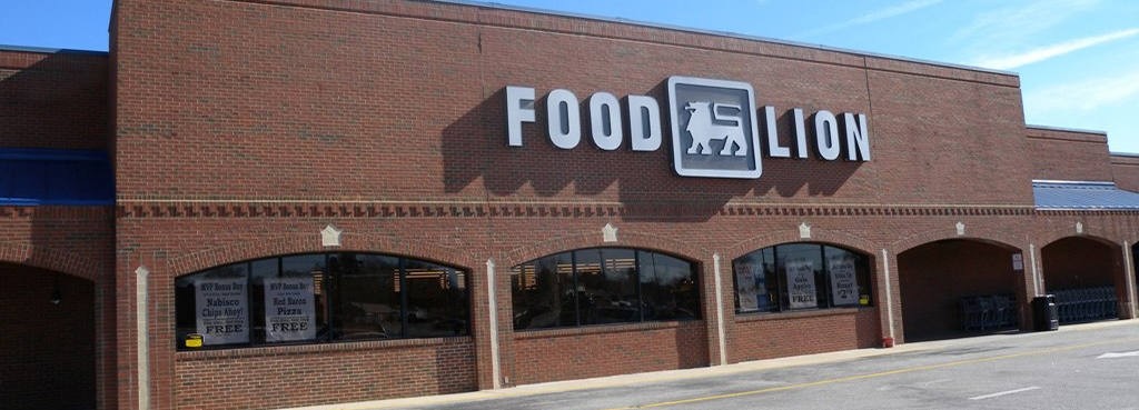
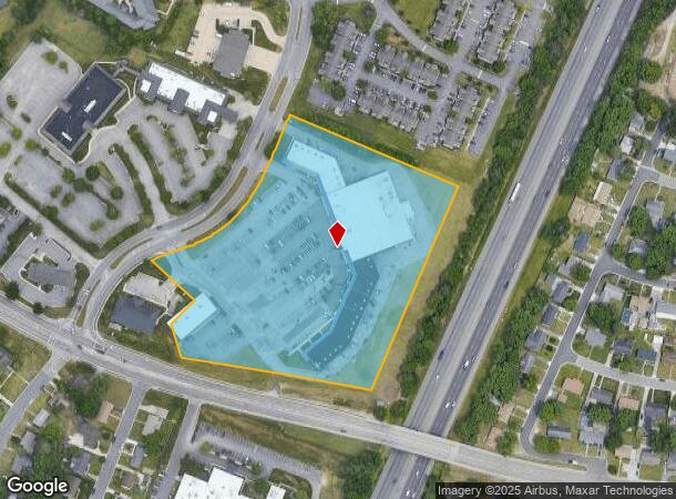
Property Record
Dunlop Vlg, Colonial Heights, VA 23834
NEARBY LISTINGS FOR SALE OR LEASE
Property Detail
Dunlop Vlg
Richmond, VA
Dunlop Farms
6702-02-0E-001
SUB: DUNLOP FARMS**SECTION: 3**BLOCK: E 9.00 AC**LOT: 1
Stripcommercialcenter
Colonial Heights
X
Virginia
51041C0345E
1
2024
9 AC
2024
Colonial Heights
830200
Richmond VA
77,315 SF
DEMOGRAPHICS near Dunlop Vlg
1 Mile
3 Mile
5 Mile
2024 Total Population
7,140
41,608
101,814
2029 Population
7,229
43,046
104,843
Pop Growth 2024-2029
+ 1.25%
+ 3.46%
+ 2.98%
Average Age
43
38
38
2024 Total Households
3,038
15,573
36,498
HH Growth 2024-2029
+ 1.18%
+ 3.44%
+ 2.88%
Median Household Inc
$59,311
$57,363
$56,634
Avg Household Size
2.30
2.30
2.40
2024 Avg HH Vehicles
2.00
2.00
2.00
Median Home Value
$199,932
$197,638
$192,510
Median Year Built
1971
1970
1975
Nearby Places
- Restaurants
- Banks
- Shops
- Fitness
- Groceries
PUBLIC TRANSPORTATION
COMMUTER RAIL
Petersburg Amtrak Station (Carolinian - Amtrak, Northeast Regional - Amtrak, Palmetto - Amtrak, Silver Meteor - Amtrak, Silver Star - Amtrak)
DRIVE
WALK
Distance
Petersburg Amtrak Station (Carolinian - Amtrak, Northeast Regional - Amtrak, Palmetto - Amtrak, Silver Meteor - Amtrak, Silver Star - Amtrak)
9 min
4.1 mi
AIRPORT
Richmond International
DRIVE
WALK
Distance
Richmond International
38 min
25.7 mi
Freight Ports
Virginia Port Authority - Richmond
DRIVE
WALK
Distance
Virginia Port Authority - Richmond
27 min
18.0 mi
Nearby Properties
Address
Land Use
TOTAL SIZE
Lot Size
Zoning
Address
Land Use
TOTAL SIZE
Lot Size
Zoning
500 SF
390.12 AC
R7 - SINGL
Address
Land Use
TOTAL SIZE
Lot Size
Zoning
165,942 SF
0.57 AC
R7 - SINGL
Address
Land Use
TOTAL SIZE
Lot Size
Zoning
806,770 SF
132.98 AC
C5 - GEN B
Address
Land Use
TOTAL SIZE
Lot Size
Zoning
24,440 SF
16.58 AC
C4 - REGIO
Address
Land Use
TOTAL SIZE
Lot Size
Zoning
51,588 SF
13.86 AC
RMF - RES,
Address
Land Use
TOTAL SIZE
Lot Size
Zoning
89,260 SF
47.74 AC
I2 - GEN I
Address
Land Use
TOTAL SIZE
Lot Size
Zoning
482,476 SF
19.75 AC
I2 - GEN I
Address
Land Use
TOTAL SIZE
Lot Size
Zoning
209,515 SF
21.20 AC
B3
Address
Land Use
TOTAL SIZE
Lot Size
Zoning
188,368 SF
18.96 AC
B1
Address
Land Use
TOTAL SIZE
Lot Size
Zoning
95,944 SF
15.75 AC
C2 - NBHD
Address
Land Use
TOTAL SIZE
Lot Size
Zoning
132,121 SF
61.15 AC
I2 - GEN I
Address
Land Use
TOTAL SIZE
Lot Size
Zoning
3.10 AC
M-1
Address
Land Use
TOTAL SIZE
Lot Size
Zoning
130,698 SF
10.78 AC
PUD
Address
Land Use
TOTAL SIZE
Lot Size
Zoning
223,211 SF
19.99 AC
B3
Address
Land Use
TOTAL SIZE
Lot Size
Zoning
57,011 SF
4.45 AC
BB
Address
Land Use
TOTAL SIZE
Lot Size
Zoning
89,138 SF
6.45 AC
PUD
Address
Land Use
TOTAL SIZE
Lot Size
Zoning
173,829 SF
13.73 AC
B2
Address
Land Use
TOTAL SIZE
Lot Size
Zoning
129,600 SF
12.21 AC
PUD
Address
Land Use
TOTAL SIZE
Lot Size
Zoning
86,204 SF
54.43 AC
Address
Land Use
TOTAL SIZE
Lot Size
Zoning
100 SF
12.39 AC
R7 - SINGL
Address
Land Use
TOTAL SIZE
Lot Size
Zoning
56,701 SF
7.53 AC
R4
Address
Land Use
TOTAL SIZE
Lot Size
Zoning
128,848 SF
13.24 AC
B3
Address
Land Use
TOTAL SIZE
Lot Size
Zoning
92,701 SF
2.87 AC
B1
Address
Land Use
TOTAL SIZE
Lot Size
Zoning
314,688 SF
68.99 AC
I2 - GEN I
Address
Land Use
TOTAL SIZE
Lot Size
Zoning
140,000 SF
1 AC
999
Address
Land Use
TOTAL SIZE
Lot Size
Zoning
89,734 SF
2.85 AC
B1
Address
Land Use
TOTAL SIZE
Lot Size
Zoning
86,387 SF
10.91 AC
B3
Address
Land Use
TOTAL SIZE
Lot Size
Zoning
220,009 SF
66.16 AC
I2 - GEN I
Address
Land Use
TOTAL SIZE
Lot Size
Zoning
50,552 SF
9.33 AC
C5 - GEN B
Address
Land Use
TOTAL SIZE
Lot Size
Zoning
218,821 SF
11.46 AC
I1 - LT IN
The World's #1 Commercial Real Estate Marketplace
Connect with us
© 2025 CoStar Group
The information above has been obtained from sources believed reliable. While we do not doubt its accuracy we have not verified it and make no guarantee, warranty or representation about it. It is your responsibility to independently confirm its accuracy and completeness. Any projections, opinions, assumptions, or estimates used are for example only and do not represent the current or future performance of the property. The value of this transaction to you depends on tax and other factors which should be evaluated by your tax, financial, and legal advisors. You and your advisors should conduct a careful, independent investigation of the property to determine to your satisfaction the suitability of the property for your needs.