Property Record
Belleville Rd, Canton, MI 48188
This Property Is For Sale
NEARBY LISTINGS FOR SALE OR LEASE
Property Detail
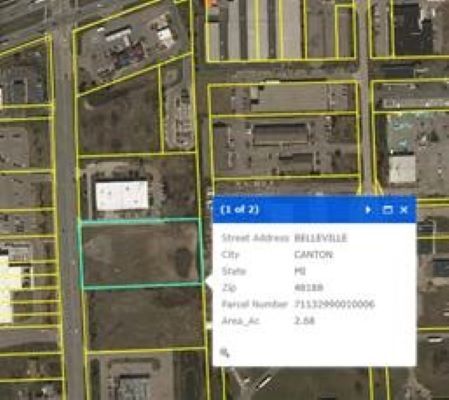
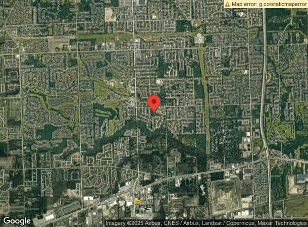
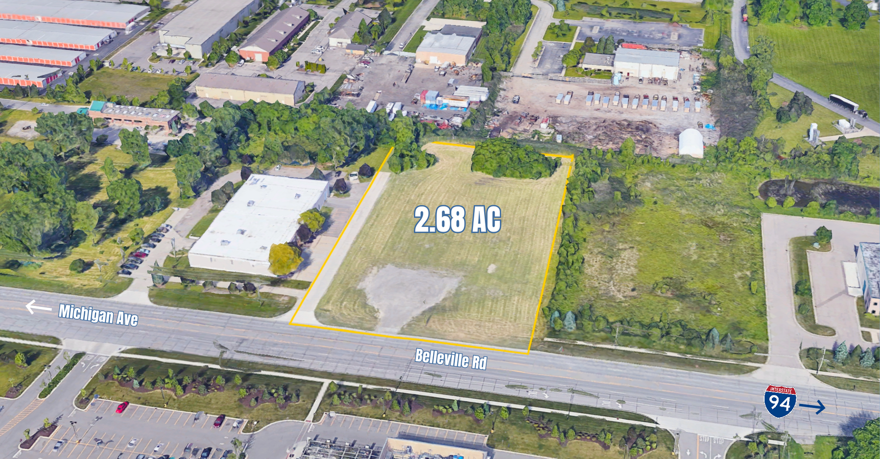
Belleville Rd
Detroit-Warren-Dearborn, MI
Dye Bros Wayne Park Sub
71-132-99-0010-006
33X1B2B1 PT OF SE 1/4 SEC 33 T2S R8E BEG N0DEG 03M 50S W 1805.91FT FROM SE COR OF SEC 33 TH N89DEG 34M 30S W 452.20FT TH N0DEG 18M W 250FT TH S89DEG 34M 30S E 453.24FT TH S0DEG 03M 50S E 250FT POB 2.60 AC
Industrialacreage
Wayne
X
Michigan
26163C0215E
0010
2024
2.60 AC
2024
Airport District
564800
Detroit
DEMOGRAPHICS near Belleville Rd
1 Mile
3 Mile
5 Mile
2024 Total Population
3,825
43,551
129,058
2029 Population
3,813
41,965
124,457
Pop Growth 2024-2029
(0.31%)
(3.64%)
(3.57%)
Average Age
41
40
40
2024 Total Households
1,521
16,438
49,986
HH Growth 2024-2029
(0.13%)
(3.58%)
(3.58%)
Median Household Inc
$104,284
$104,178
$88,102
Avg Household Size
2.50
2.60
2.50
2024 Avg HH Vehicles
2.00
2.00
2.00
Median Home Value
$261,820
$295,210
$264,786
Median Year Built
1995
1995
1987
Nearby Places
- Restaurants
- Banks
- Shops
- Fitness
- Groceries
PUBLIC TRANSPORTATION
AIRPORT
Detroit Metro Wayne County
DRIVE
WALK
Distance
Detroit Metro Wayne County
19 min
13.8 mi
Windsor International
DRIVE
WALK
Distance
Windsor International
62 min
41.0 mi
Freight Ports
Port of Toledo
DRIVE
WALK
Distance
Port of Toledo
69 min
55.4 mi
Nearby Properties
Address
Land Use
TOTAL SIZE
Lot Size
Zoning
Address
Land Use
TOTAL SIZE
Lot Size
Zoning
347,606 SF
71.56 AC
M2 GEN
Address
Land Use
TOTAL SIZE
Lot Size
Zoning
17.50 AC
R-2
Address
Land Use
TOTAL SIZE
Lot Size
Zoning
39.50 AC
MR
Address
Land Use
TOTAL SIZE
Lot Size
Zoning
71.56 AC
M2 GEN
Address
Land Use
TOTAL SIZE
Lot Size
Zoning
176,796 SF
17.08 AC
C-2
Address
Land Use
TOTAL SIZE
Lot Size
Zoning
167,491 SF
18.59 AC
Address
Land Use
TOTAL SIZE
Lot Size
Zoning
1,182 SF
25.21 AC
G-1
Address
Land Use
TOTAL SIZE
Lot Size
Zoning
311,556 SF
23.17 AC
C-3
Address
Land Use
TOTAL SIZE
Lot Size
Zoning
182,952 SF
82.77 AC
Address
Land Use
TOTAL SIZE
Lot Size
Zoning
685,506 SF
44.25 AC
M1 LIG
Address
Land Use
TOTAL SIZE
Lot Size
Zoning
524,579 SF
42.18 AC
M2 GEN
Address
Land Use
TOTAL SIZE
Lot Size
Zoning
20.91 AC
Address
Land Use
TOTAL SIZE
Lot Size
Zoning
137,143 SF
15.54 AC
C-3
Address
Land Use
TOTAL SIZE
Lot Size
Zoning
455,367 SF
32.59 AC
Address
Land Use
TOTAL SIZE
Lot Size
Zoning
19.49 AC
R-6
Address
Land Use
TOTAL SIZE
Lot Size
Zoning
172,602 SF
14.51 AC
R-6
Address
Land Use
TOTAL SIZE
Lot Size
Zoning
18.24 AC
R-6
Address
Land Use
TOTAL SIZE
Lot Size
Zoning
443,082 SF
30.01 AC
LI-2
Address
Land Use
TOTAL SIZE
Lot Size
Zoning
Address
Land Use
TOTAL SIZE
Lot Size
Zoning
12.46 AC
MR
Address
Land Use
TOTAL SIZE
Lot Size
Zoning
186,967 SF
9.75 AC
Address
Land Use
TOTAL SIZE
Lot Size
Zoning
11.40 AC
MR
Address
Land Use
TOTAL SIZE
Lot Size
Zoning
16.68 AC
Address
Land Use
TOTAL SIZE
Lot Size
Zoning
105,250 SF
11.20 AC
C-3
Address
Land Use
TOTAL SIZE
Lot Size
Zoning
26.35 AC
Address
Land Use
TOTAL SIZE
Lot Size
Zoning
269,649 SF
18.27 AC
LI-1
Address
Land Use
TOTAL SIZE
Lot Size
Zoning
81,441 SF
14.66 AC
RR
Address
Land Use
TOTAL SIZE
Lot Size
Zoning
85,612 SF
17.66 AC
R-1
Address
Land Use
TOTAL SIZE
Lot Size
Zoning
73,056 SF
7.44 AC
C-3
Address
Land Use
TOTAL SIZE
Lot Size
Zoning
100,098 SF
10.52 AC
The World's #1 Commercial Real Estate Marketplace
Connect with us
© 2025 CoStar Group
The information above has been obtained from sources believed reliable. While we do not doubt its accuracy we have not verified it and make no guarantee, warranty or representation about it. It is your responsibility to independently confirm its accuracy and completeness. Any projections, opinions, assumptions, or estimates used are for example only and do not represent the current or future performance of the property. The value of this transaction to you depends on tax and other factors which should be evaluated by your tax, financial, and legal advisors. You and your advisors should conduct a careful, independent investigation of the property to determine to your satisfaction the suitability of the property for your needs.