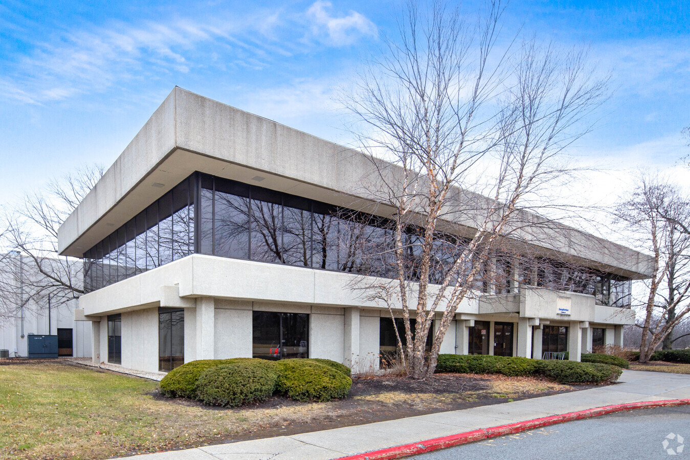
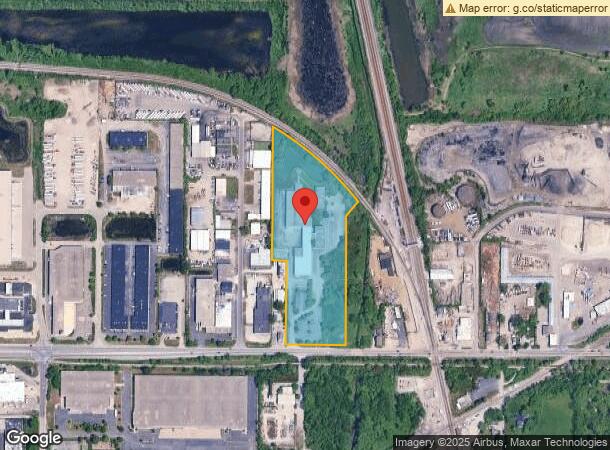
Property Record
28800 N Energy Dr, Green Oaks, IL 60048
This Property Is For Sale
Current Lease Availabilities
NEARBY LISTINGS FOR SALE OR LEASE
Property Detail
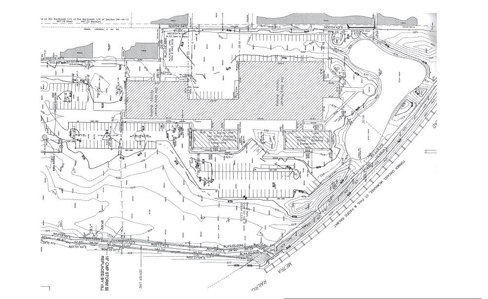
28800 N Energy Dr
11-24-100-065
PT NE NW; BEG 515.63N OF SWCOR,N770.75,SE ALG SW ROW RR 66 2.54,S40D37W 106,S TO SLN NE NW, W ALG SLN TO PNT 5RDS E OF WLN, N31.25 RDS, W 5RDS TO POB SECTION 24 TOWNSHIP 44 RAN
Industrialgeneral
Lake
AE
Illinois
17097C0167K
9.85 AC
2022
South Lake County
2023
Chicago
863701
Chicago-Naperville-Elgin, IL-IN-WI
DEMOGRAPHICS near 28800 N Energy Dr
1 Mile
3 Mile
5 Mile
2024 Total Population
2,541
32,075
114,267
2029 Population
2,549
32,181
113,472
Pop Growth 2024-2029
+ 0.31%
+ 0.33%
(0.70%)
Average Age
44
41
39
2024 Total Households
974
12,019
39,322
HH Growth 2024-2029
(0.10%)
+ 0.25%
(0.74%)
Median Household Inc
$99,544
$114,642
$107,149
Avg Household Size
2.40
2.50
2.60
2024 Avg HH Vehicles
2.00
2.00
2.00
Median Home Value
$467,293
$508,356
$439,136
Median Year Built
1988
1978
1979
Nearby Places
- Restaurants
- Banks
- Shops
- Fitness
- Groceries
PUBLIC TRANSPORTATION
COMMUTER RAIL
Lake Bluff Station (Union Pacific North Line - Northeast Illinois Regional Commuter Railroad (Metra))
DRIVE
WALK
Distance
Lake Bluff Station (Union Pacific North Line - Northeast Illinois Regional Commuter Railroad (Metra))
8 min
3.4 mi
Libertyville Station (Milwaukee District North Line - Northeast Illinois Regional Commuter Railroad (Metra))
DRIVE
WALK
Distance
Libertyville Station (Milwaukee District North Line - Northeast Illinois Regional Commuter Railroad (Metra))
7 min
3.5 mi
AIRPORT
Chicago O'Hare International
DRIVE
WALK
Distance
Chicago O'Hare International
33 min
24.9 mi
Freight Ports
Port Milwaukee
DRIVE
WALK
Distance
Port Milwaukee
66 min
55.0 mi
Nearby Properties
Address
Land Use
TOTAL SIZE
Lot Size
Zoning
Address
Land Use
TOTAL SIZE
Lot Size
Zoning
182.08 AC
Address
Land Use
TOTAL SIZE
Lot Size
Zoning
74.05 AC
Address
Land Use
TOTAL SIZE
Lot Size
Zoning
19.92 AC
Address
Land Use
TOTAL SIZE
Lot Size
Zoning
36,797,586 SF
48.98 AC
Address
Land Use
TOTAL SIZE
Lot Size
Zoning
296.29 AC
Address
Land Use
TOTAL SIZE
Lot Size
Zoning
13.85 AC
Address
Land Use
TOTAL SIZE
Lot Size
Zoning
17.35 AC
Address
Land Use
TOTAL SIZE
Lot Size
Zoning
Address
Land Use
TOTAL SIZE
Lot Size
Zoning
Address
Land Use
TOTAL SIZE
Lot Size
Zoning
25.66 AC
Address
Land Use
TOTAL SIZE
Lot Size
Zoning
66.57 AC
Address
Land Use
TOTAL SIZE
Lot Size
Zoning
7.98 AC
Address
Land Use
TOTAL SIZE
Lot Size
Zoning
10.68 AC
Address
Land Use
TOTAL SIZE
Lot Size
Zoning
10.24 AC
Address
Land Use
TOTAL SIZE
Lot Size
Zoning
14.03 AC
Address
Land Use
TOTAL SIZE
Lot Size
Zoning
16.06 AC
Address
Land Use
TOTAL SIZE
Lot Size
Zoning
7.99 AC
Address
Land Use
TOTAL SIZE
Lot Size
Zoning
Address
Land Use
TOTAL SIZE
Lot Size
Zoning
Address
Land Use
TOTAL SIZE
Lot Size
Zoning
3.57 AC
Address
Land Use
TOTAL SIZE
Lot Size
Zoning
8.81 AC
Address
Land Use
TOTAL SIZE
Lot Size
Zoning
225,626 SF
4.11 AC
Address
Land Use
TOTAL SIZE
Lot Size
Zoning
148,512 SF
1.83 AC
Address
Land Use
TOTAL SIZE
Lot Size
Zoning
329,752 SF
15.60 AC
Address
Land Use
TOTAL SIZE
Lot Size
Zoning
394,910 SF
20.13 AC
Address
Land Use
TOTAL SIZE
Lot Size
Zoning
14.49 AC
Address
Land Use
TOTAL SIZE
Lot Size
Zoning
1,082,769 SF
31.84 AC
Address
Land Use
TOTAL SIZE
Lot Size
Zoning
Address
Land Use
TOTAL SIZE
Lot Size
Zoning
9.04 AC
Address
Land Use
TOTAL SIZE
Lot Size
Zoning
11.34 AC
The World's #1 Commercial Real Estate Marketplace
Connect with us
© 2025 CoStar Group
The information above has been obtained from sources believed reliable. While we do not doubt its accuracy we have not verified it and make no guarantee, warranty or representation about it. It is your responsibility to independently confirm its accuracy and completeness. Any projections, opinions, assumptions, or estimates used are for example only and do not represent the current or future performance of the property. The value of this transaction to you depends on tax and other factors which should be evaluated by your tax, financial, and legal advisors. You and your advisors should conduct a careful, independent investigation of the property to determine to your satisfaction the suitability of the property for your needs.