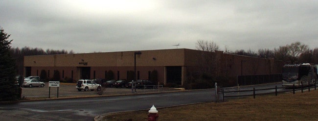
Property Record
1 Kramer Way, Montville, NJ 07045

Property Detail
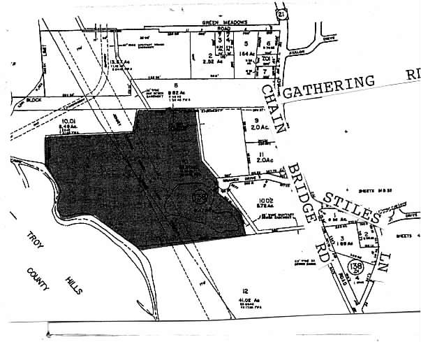
1 Kramer Way
21-00138-0000-00010
Morris
Industrialgeneral
New Jersey
I2
10
AE The base floodplain where base flood elevations are provided. AE Zones are now used on new format FIRMs instead of A1-A30 Zones.
33.01 AC
2024
Eastern Morris
2025
Northern New Jersey
040803
Newark, NJ
79,950 SF
NEARBY LISTINGS FOR SALE OR LEASE
DEMOGRAPHICS near 1 Kramer Way
1 mile
3 mile
5 mile
2025 Total Population
8,750
51,899
131,486
2030 Population
8,964
53,463
135,992
Pop Growth 2025-2030
+ 2.45%
+ 3.01%
+ 3.43%
Average Age
43
42
43
2025 Total Households
2,896
19,456
49,021
HH Growth 2025-2030
+ 2.49%
+ 3.05%
+ 3.49%
Median Household Inc
$155,291
$121,774
$134,312
Avg Household Size
2.90
2.60
2.60
2025 Avg HH Vehicles
2.00
2.00
2.00
Median Home Value
$618,654
$641,599
$657,645
Median Year Built
1965
1971
1969
Nearby Places
Map Layers
Map Styles
 Street
 Aerial
Layers
 Traffic
 Biking
Places
Listings with unknown addresses are not visible on the map
- Restaurants
- Banks
- Shops
- Fitness
- Groceries
PUBLIC TRANSPORTATION
COMMUTER RAIL
Towaco (Montclair-Boonton Line - NJ Transit Commuter Rail (NJ Transit))
Drive
Walk
Distance
Towaco (Montclair-Boonton Line - NJ Transit Commuter Rail (NJ Transit))
10 min
4.3 mi
Boonton (Montclair-Boonton Line - NJ Transit Commuter Rail (NJ Transit))
Drive
Walk
Distance
Boonton (Montclair-Boonton Line - NJ Transit Commuter Rail (NJ Transit))
12 min
4.8 mi
AIRPORT
Newark Liberty International
Drive
Walk
Distance
Newark Liberty International
35 min
24.5 mi
LaGuardia
Drive
Walk
Distance
LaGuardia
52 min
37.1 mi
John F Kennedy International
Drive
Walk
Distance
John F Kennedy International
66 min
48.2 mi
Freight Ports
Maher Terminal
Drive
Walk
Distance
Maher Terminal
39 min
23.1 mi
Nearby Properties
Address
Land Use
TOTAL SIZE
Lot Size
Zoning
Address
Land Use
TOTAL SIZE
Lot Size
Zoning
98.27 AC
AH1
Address
Land Use
TOTAL SIZE
Lot Size
Zoning
11,353 SF
9.29 AC
COD
Address
Land Use
TOTAL SIZE
Lot Size
Zoning
119,552 SF
129 AC
I1A
Address
Land Use
TOTAL SIZE
Lot Size
Zoning
3.86 AC
O-3
Address
Land Use
TOTAL SIZE
Lot Size
Zoning
32.61 AC
R-5
Address
Land Use
TOTAL SIZE
Lot Size
Zoning
201,648 SF
19.35 AC
B-1
Address
Land Use
TOTAL SIZE
Lot Size
Zoning
197,023 SF
22.08 AC
AHMU
Address
Land Use
TOTAL SIZE
Lot Size
Zoning
91,872 SF
31.16 AC
B-1
Address
Land Use
TOTAL SIZE
Lot Size
Zoning
310,954 SF
22.99 AC
SED5
Address
Land Use
TOTAL SIZE
Lot Size
Zoning
259,325 SF
13.62 AC
I1A
Address
Land Use
TOTAL SIZE
Lot Size
Zoning
140,560 SF
49.81 AC
R27A
Address
Land Use
TOTAL SIZE
Lot Size
Zoning
323,904 SF
12 AC
SED5
Address
Land Use
TOTAL SIZE
Lot Size
Zoning
4,172 SF
338 AC
R-1
Address
Land Use
TOTAL SIZE
Lot Size
Zoning
132,411 SF
24.87 AC
B-5
Address
Land Use
TOTAL SIZE
Lot Size
Zoning
10.80 AC
R-5
Address
Land Use
TOTAL SIZE
Lot Size
Zoning
4.99 AC
OB
Address
Land Use
TOTAL SIZE
Lot Size
Zoning
251,480 SF
36.14 AC
I1A
Address
Land Use
TOTAL SIZE
Lot Size
Zoning
4.02 AC
R-3
Address
Land Use
TOTAL SIZE
Lot Size
Zoning
8,910 SF
20.68 AC
L-1
Address
Land Use
TOTAL SIZE
Lot Size
Zoning
11.52 AC
R-5
Address
Land Use
TOTAL SIZE
Lot Size
Zoning
266,624 SF
18.13 AC
I1A
Address
Land Use
TOTAL SIZE
Lot Size
Zoning
11.05 AC
R-5
Address
Land Use
TOTAL SIZE
Lot Size
Zoning
12.64 AC
R-5
Address
Land Use
TOTAL SIZE
Lot Size
Zoning
13.70 AC
R-5
Address
Land Use
TOTAL SIZE
Lot Size
Zoning
179,144 SF
40.54 AC
R-3
Address
Land Use
TOTAL SIZE
Lot Size
Zoning
Address
Land Use
TOTAL SIZE
Lot Size
Zoning
7.59 AC
B2
Address
Land Use
TOTAL SIZE
Lot Size
Zoning
214,588 SF
17.38 AC
I1A
Address
Land Use
TOTAL SIZE
Lot Size
Zoning
209,650 SF
17.81 AC
SED5
Address
Land Use
TOTAL SIZE
Lot Size
Zoning
11.07 AC
R-5
The World's #1 Commercial Real Estate Marketplace
Connect with us
© 2026 CoStar Group
The information above has been obtained from sources believed reliable. While we do not doubt its accuracy we have not verified it and make no guarantee, warranty or representation about it. It is your responsibility to independently confirm its accuracy and completeness. Any projections, opinions, assumptions, or estimates used are for example only and do not represent the current or future performance of the property. The value of this transaction to you depends on tax and other factors which should be evaluated by your tax, financial, and legal advisors. You and your advisors should conduct a careful, independent investigation of the property to determine to your satisfaction the suitability of the property for your needs.