Property Record
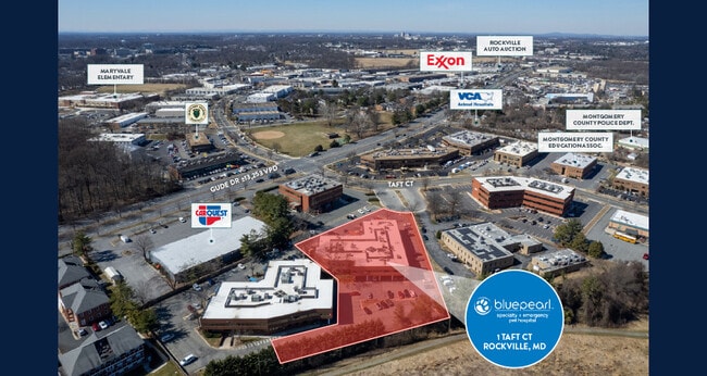
1 Taft Ct, Rockville, MD 20850

Current Lease Availabilities
NEARBY LISTINGS FOR SALE OR LEASE
Property Detail
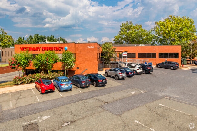
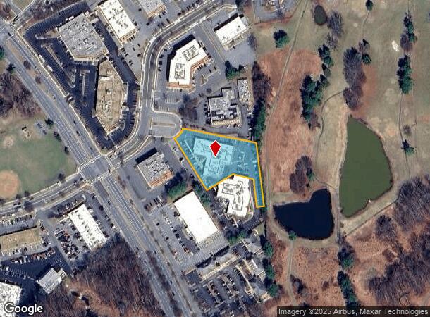
1 Taft Ct
Washington-Arlington-Alexandria, DC-VA-MD-WV
Rockville Town
04-03724393
RED GATE INDUSTRIAL OWNERSHIP LOT
Storebuilding
Montgomery
X
Maryland
51059C0075E
4a
2024
1.47 AC
2025
Rockville
700903
Washington, DC
34,174 SF
DEMOGRAPHICS near 1 Taft Ct
1 Mile
3 Mile
5 Mile
2024 Total Population
7,419
108,157
333,846
2029 Population
7,302
106,896
330,435
Pop Growth 2024-2029
(1.58%)
(1.17%)
(1.02%)
Average Age
38
41
41
2024 Total Households
2,352
40,612
124,386
HH Growth 2024-2029
(1.83%)
(1.23%)
(1.03%)
Median Household Inc
$110,159
$108,872
$110,000
Avg Household Size
2.90
2.60
2.60
2024 Avg HH Vehicles
2.00
2.00
2.00
Median Home Value
$461,181
$569,157
$543,847
Median Year Built
1959
1975
1980
Nearby Places
Map Layers
Map Styles
 Street
 Aerial
- Restaurants
- Banks
- Shops
- Fitness
- Groceries
PUBLIC TRANSPORTATION
COMMUTER RAIL
Rockville (BRUNSWICK - WASHINGTON - Maryland Area Regional Commuter Trains (The MARC), Brunswick Line - Maryland Area Regional Commuter Trains (The MARC))
DRIVE
WALK
Distance
Rockville (BRUNSWICK - WASHINGTON - Maryland Area Regional Commuter Trains (The MARC), Brunswick Line - Maryland Area Regional Commuter Trains (The MARC))
4 min
1.6 mi
Washington Grove (BRUNSWICK - WASHINGTON - Maryland Area Regional Commuter Trains (The MARC), Brunswick Line - Maryland Area Regional Commuter Trains (The MARC))
DRIVE
WALK
Distance
Washington Grove (BRUNSWICK - WASHINGTON - Maryland Area Regional Commuter Trains (The MARC), Brunswick Line - Maryland Area Regional Commuter Trains (The MARC))
10 min
4.6 mi
AIRPORT
Ronald Reagan Washington Ntl
DRIVE
WALK
Distance
Ronald Reagan Washington Ntl
41 min
20.4 mi
Washington Dulles International
DRIVE
WALK
Distance
Washington Dulles International
48 min
29.2 mi
Baltimore/Washington International Thurgood Marshall
DRIVE
WALK
Distance
Baltimore/Washington International Thurgood Marshall
47 min
35.3 mi
Freight Ports
Port of Baltimore
DRIVE
WALK
Distance
Port of Baltimore
52 min
38.2 mi
Nearby Properties
Address
Land Use
TOTAL SIZE
Lot Size
Zoning
Address
Land Use
TOTAL SIZE
Lot Size
Zoning
987,382 SF
5 AC
MXTD
Address
Land Use
TOTAL SIZE
Lot Size
Zoning
1,332,482 SF
3.79 AC
CR2.0
Address
Land Use
TOTAL SIZE
Lot Size
Zoning
1,136,684 SF
84.61 AC
R200
Address
Land Use
TOTAL SIZE
Lot Size
Zoning
515,000 SF
5.23 AC
CR1.5
Address
Land Use
TOTAL SIZE
Lot Size
Zoning
978,527 SF
11.54 AC
03
Address
Land Use
TOTAL SIZE
Lot Size
Zoning
414,000 SF
7.28 AC
MXCD
Address
Land Use
TOTAL SIZE
Lot Size
Zoning
393,977 SF
17.88 AC
MXCD
Address
Land Use
TOTAL SIZE
Lot Size
Zoning
815,414 SF
3.27 AC
CR4.0
Address
Land Use
TOTAL SIZE
Lot Size
Zoning
223,520 SF
2.77 AC
CR2.0
Address
Land Use
TOTAL SIZE
Lot Size
Zoning
185,000 SF
2.60 AC
EOF
Address
Land Use
TOTAL SIZE
Lot Size
Zoning
330,650 SF
2.89 AC
MXTD
Address
Land Use
TOTAL SIZE
Lot Size
Zoning
407,130 SF
4.62 AC
CRT1.
Address
Land Use
TOTAL SIZE
Lot Size
Zoning
363,000 SF
4.37 AC
MXTD
Address
Land Use
TOTAL SIZE
Lot Size
Zoning
515,740 SF
19.97 AC
R20
Address
Land Use
TOTAL SIZE
Lot Size
Zoning
405,742 SF
14.48 AC
R30
Address
Land Use
TOTAL SIZE
Lot Size
Zoning
243,000 SF
2.10 AC
PD-KS
Address
Land Use
TOTAL SIZE
Lot Size
Zoning
311,500 SF
29.05 AC
R60
Address
Land Use
TOTAL SIZE
Lot Size
Zoning
325,990 SF
51.21 AC
CRT07
Address
Land Use
TOTAL SIZE
Lot Size
Zoning
152,330 SF
CR
Address
Land Use
TOTAL SIZE
Lot Size
Zoning
316,883 SF
8.62 AC
OCPD
Address
Land Use
TOTAL SIZE
Lot Size
Zoning
19.50 AC
MXCD
Address
Land Use
TOTAL SIZE
Lot Size
Zoning
172,740 SF
6.93 AC
PD-RC
Address
Land Use
TOTAL SIZE
Lot Size
Zoning
450,248 SF
26.80 AC
R200
Address
Land Use
TOTAL SIZE
Lot Size
Zoning
230,460 SF
6.38 AC
03
Address
Land Use
TOTAL SIZE
Lot Size
Zoning
230,460 SF
6.36 AC
03
Address
Land Use
TOTAL SIZE
Lot Size
Zoning
167,000 SF
0.57 AC
MXNC
Address
Land Use
TOTAL SIZE
Lot Size
Zoning
164,764 SF
15.42 AC
NR0.7
Address
Land Use
TOTAL SIZE
Lot Size
Zoning
316,973 SF
29.64 AC
R90
Address
Land Use
TOTAL SIZE
Lot Size
Zoning
192,356 SF
5.46 AC
MXE
Address
Land Use
TOTAL SIZE
Lot Size
Zoning
124,920 SF
11.52 AC
CR2.2
The World's #1 Commercial Real Estate Marketplace
Connect with us
© 2025 CoStar Group
The information above has been obtained from sources believed reliable. While we do not doubt its accuracy we have not verified it and make no guarantee, warranty or representation about it. It is your responsibility to independently confirm its accuracy and completeness. Any projections, opinions, assumptions, or estimates used are for example only and do not represent the current or future performance of the property. The value of this transaction to you depends on tax and other factors which should be evaluated by your tax, financial, and legal advisors. You and your advisors should conduct a careful, independent investigation of the property to determine to your satisfaction the suitability of the property for your needs.