Property Record
1 W Superior St, Chicago, IL 60654

Current Lease Availabilities
NEARBY LISTINGS FOR SALE OR LEASE
Property Detail
1 W Superior St
17-09-213-028-0000
Ernest Hess
Commercialnec
Cook
X
Illinois
17031C0419J
1-4
2023
1.79 AC
2025
River North
081700
Chicago
935,613 SF
Chicago-Naperville-Elgin, IL-IN-WI
DEMOGRAPHICS near 1 W Superior St
1 Mile
3 Mile
5 Mile
2024 Total Population
141,346
420,106
809,641
2029 Population
141,801
414,980
785,753
Pop Growth 2024-2029
+ 0.32%
(1.22%)
(2.95%)
Average Age
40
37
37
2024 Total Households
88,368
232,935
408,371
HH Growth 2024-2029
+ 0.01%
(1.35%)
(2.86%)
Median Household Inc
$118,793
$114,829
$97,290
Avg Household Size
1.60
1.70
1.90
2024 Avg HH Vehicles
1.00
1.00
1.00
Median Home Value
$542,376
$513,789
$476,472
Median Year Built
1995
1986
1971
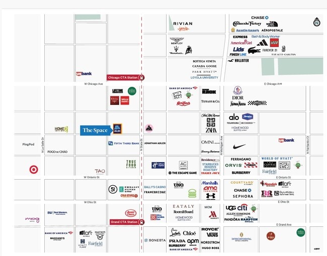
Nearby Places
Map Layers
Map Styles
 Street
 Aerial
- Restaurants
- Banks
- Shops
- Fitness
- Groceries
PUBLIC TRANSPORTATION
TRANSIT/SUBWAY
Chicago Avenue Station (Red Line) (Red Line - Chicago Transit Authority "L" Trains (The "L"))
DRIVE
WALK
Distance
Chicago Avenue Station (Red Line) (Red Line - Chicago Transit Authority "L" Trains (The "L"))
0 min
2 min
0.1 mi
Grand Avenue Station (Red Line) (Red Line - Chicago Transit Authority "L" Trains (The "L"))
DRIVE
WALK
Distance
Grand Avenue Station (Red Line) (Red Line - Chicago Transit Authority "L" Trains (The "L"))
0 min
4 min
0.2 mi
Chicago Avenue Station (Brown, Purple Lines) (Brown Line - Chicago Transit Authority "L" Trains (The "L"), Purple Line - Chicago Transit Authority "L" Trains (The "L"))
DRIVE
WALK
Distance
Chicago Avenue Station (Brown, Purple Lines) (Brown Line - Chicago Transit Authority "L" Trains (The "L"), Purple Line - Chicago Transit Authority "L" Trains (The "L"))
1 min
7 min
0.4 mi
Clark/Division Station (Red Line - Chicago Transit Authority "L" Trains (The "L"))
DRIVE
WALK
Distance
Clark/Division Station (Red Line - Chicago Transit Authority "L" Trains (The "L"))
1 min
13 min
0.7 mi
Merchandise Mart Station (Brown Line - Chicago Transit Authority "L" Trains (The "L"), Purple Line - Chicago Transit Authority "L" Trains (The "L"))
DRIVE
WALK
Distance
Merchandise Mart Station (Brown Line - Chicago Transit Authority "L" Trains (The "L"), Purple Line - Chicago Transit Authority "L" Trains (The "L"))
1 min
14 min
0.8 mi
COMMUTER RAIL
Chicago Millennium Station (Metra Electric Line - Northeast Illinois Regional Commuter Railroad (Metra), South Shore Line - Northeast Illinois Regional Commuter Railroad (Metra))
DRIVE
WALK
Distance
Chicago Millennium Station (Metra Electric Line - Northeast Illinois Regional Commuter Railroad (Metra), South Shore Line - Northeast Illinois Regional Commuter Railroad (Metra))
3 min
19 min
1.0 mi
Chicago Ogilvie Transportation Center (Union Pacific North Line - Northeast Illinois Regional Commuter Railroad (Metra), Union Pacific Northwest Line - Northeast Illinois Regional Commuter Railroad (Metra), Union Pacific West Line - Northeast Illinois Regional Commuter Railroad (Metra))
DRIVE
WALK
Distance
Chicago Ogilvie Transportation Center (Union Pacific North Line - Northeast Illinois Regional Commuter Railroad (Metra), Union Pacific Northwest Line - Northeast Illinois Regional Commuter Railroad (Metra), Union Pacific West Line - Northeast Illinois Regional Commuter Railroad (Metra))
4 min
1.5 mi
AIRPORT
Chicago Midway International
DRIVE
WALK
Distance
Chicago Midway International
20 min
12.1 mi
Chicago O'Hare International
DRIVE
WALK
Distance
Chicago O'Hare International
27 min
17.3 mi
Freight Ports
Port Milwaukee
DRIVE
WALK
Distance
Port Milwaukee
105 min
85.5 mi
Nearby Properties
Address
Land Use
TOTAL SIZE
Lot Size
Zoning
Address
Land Use
TOTAL SIZE
Lot Size
Zoning
4,667,723 SF
2.94 AC
DC-16
Address
Land Use
TOTAL SIZE
Lot Size
Zoning
1,546,909 SF
0.98 AC
PD 1369
Address
Land Use
TOTAL SIZE
Lot Size
Zoning
3,457,865 SF
3.74 AC
PD 70
Address
Land Use
TOTAL SIZE
Lot Size
Zoning
1,362,475 SF
1.97 AC
PD 1226
Address
Land Use
TOTAL SIZE
Lot Size
Zoning
2,343,906 SF
2.32 AC
PD 70
Address
Land Use
TOTAL SIZE
Lot Size
Zoning
1,396,750 SF
4.09 AC
PD 98
Address
Land Use
TOTAL SIZE
Lot Size
Zoning
1,810,145 SF
1.03 AC
PD 365
Address
Land Use
TOTAL SIZE
Lot Size
Zoning
3,090,691 SF
3.30 AC
PD 377,PD
Address
Land Use
TOTAL SIZE
Lot Size
Zoning
0.82 AC
PD 1115
Address
Land Use
TOTAL SIZE
Lot Size
Zoning
0.88 AC
DC-16,PD 9
Address
Land Use
TOTAL SIZE
Lot Size
Zoning
2,750,656 SF
6.29 AC
PD 1065
Address
Land Use
TOTAL SIZE
Lot Size
Zoning
1,888,207 SF
2.03 AC
PD 264
Address
Land Use
TOTAL SIZE
Lot Size
Zoning
1,496,448 SF
2 AC
PD 376
Address
Land Use
TOTAL SIZE
Lot Size
Zoning
2,429,909 SF
2.93 AC
PD 882
Address
Land Use
TOTAL SIZE
Lot Size
Zoning
2,456,900 SF
0.96 AC
PD 256
Address
Land Use
TOTAL SIZE
Lot Size
Zoning
2,612,517 SF
1.28 AC
PD 256
Address
Land Use
TOTAL SIZE
Lot Size
Zoning
4,296,046 SF
6.15 AC
DC-16
Address
Land Use
TOTAL SIZE
Lot Size
Zoning
1,215,367 SF
3.76 AC
PD 675
Address
Land Use
TOTAL SIZE
Lot Size
Zoning
3,914,400 SF
5.70 AC
DC-16
Address
Land Use
TOTAL SIZE
Lot Size
Zoning
1,502,279 SF
3.79 AC
PD 98
Address
Land Use
TOTAL SIZE
Lot Size
Zoning
1,559,966 SF
1.38 AC
DC-12
Address
Land Use
TOTAL SIZE
Lot Size
Zoning
831,084 SF
2.05 AC
PD 316
Address
Land Use
TOTAL SIZE
Lot Size
Zoning
1,316,385 SF
0.76 AC
PD 381
Address
Land Use
TOTAL SIZE
Lot Size
Zoning
1,300,110 SF
1.52 AC
PD 70
Address
Land Use
TOTAL SIZE
Lot Size
Zoning
1,231,710 SF
2.01 AC
PD 27
Address
Land Use
TOTAL SIZE
Lot Size
Zoning
1,109,372 SF
1.66 AC
PD 368
Address
Land Use
TOTAL SIZE
Lot Size
Zoning
1,051,000 SF
0.93 AC
PD 325
Address
Land Use
TOTAL SIZE
Lot Size
Zoning
0.61 AC
PD 824
Address
Land Use
TOTAL SIZE
Lot Size
Zoning
1,661,783 SF
0.56 AC
PD 500
Address
Land Use
TOTAL SIZE
Lot Size
Zoning
1,600,546 SF
1.04 AC
PD 191
The World's #1 Commercial Real Estate Marketplace
Connect with us
© 2025 CoStar Group
The information above has been obtained from sources believed reliable. While we do not doubt its accuracy we have not verified it and make no guarantee, warranty or representation about it. It is your responsibility to independently confirm its accuracy and completeness. Any projections, opinions, assumptions, or estimates used are for example only and do not represent the current or future performance of the property. The value of this transaction to you depends on tax and other factors which should be evaluated by your tax, financial, and legal advisors. You and your advisors should conduct a careful, independent investigation of the property to determine to your satisfaction the suitability of the property for your needs.