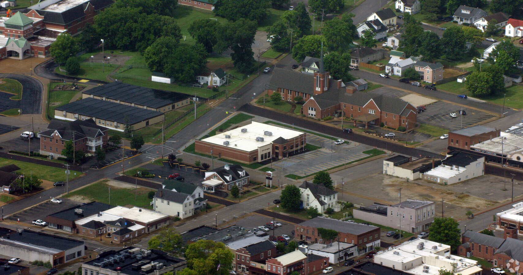
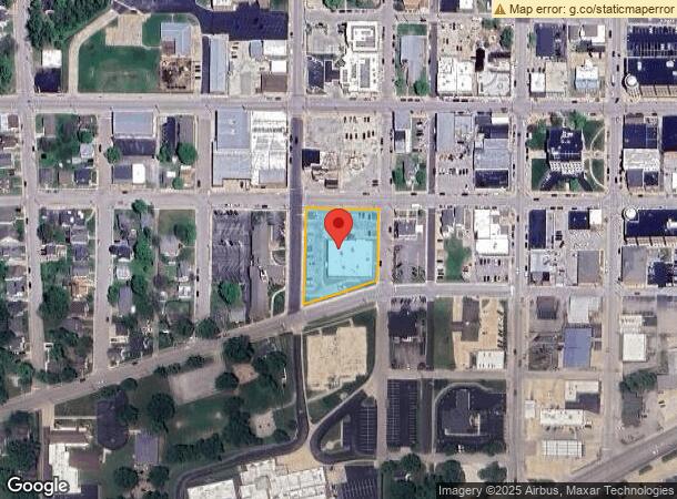
Property Record
10 E Locust St, Union, MO 63084
NEARBY LISTINGS FOR SALE OR LEASE
Property Detail
10 E Locust St
St. Louis, MO-IL
Robertsons
17-8-270-4-003-140000
CITY HALL LOTS 1-9 & VAC ALLEY BLK 7 ROBERTSONS ADDN
Taxexempt
Franklin
X
Missouri
29071C0285D
1-9
0
1.10 AC
2023
Franklin County
8006013046
St. Louis
11,794 SF
DEMOGRAPHICS near 10 E Locust St
1 Mile
3 Mile
5 Mile
2024 Total Population
5,805
13,406
21,736
2029 Population
5,939
13,724
22,316
Pop Growth 2024-2029
+ 2.31%
+ 2.37%
+ 2.67%
Average Age
39
39
40
2024 Total Households
2,302
5,170
8,304
HH Growth 2024-2029
+ 2.26%
+ 2.32%
+ 2.61%
Median Household Inc
$60,781
$67,627
$72,068
Avg Household Size
2.50
2.50
2.50
2024 Avg HH Vehicles
2.00
2.00
2.00
Median Home Value
$151,866
$182,081
$209,570
Median Year Built
1989
1993
1993
Nearby Places
- Restaurants
- Banks
- Shops
- Fitness
- Groceries
PUBLIC TRANSPORTATION
COMMUTER RAIL
Washington Amtrak Station (Lincoln Service Missouri River Runner - Amtrak, Missouri River Runner - Amtrak)
DRIVE
WALK
Distance
Washington Amtrak Station (Lincoln Service Missouri River Runner - Amtrak, Missouri River Runner - Amtrak)
17 min
8.8 mi
Freight Ports
Tulsa Port of Inola
DRIVE
WALK
Distance
Tulsa Port of Inola
375 min
340.2 mi
Nearby Properties
Address
Land Use
TOTAL SIZE
Lot Size
Zoning
Address
Land Use
TOTAL SIZE
Lot Size
Zoning
81,944 SF
85.90 AC
Address
Land Use
TOTAL SIZE
Lot Size
Zoning
2,880 SF
66 AC
Address
Land Use
TOTAL SIZE
Lot Size
Zoning
130,170 SF
9.80 AC
Address
Land Use
TOTAL SIZE
Lot Size
Zoning
82,428 SF
6.50 AC
Address
Land Use
TOTAL SIZE
Lot Size
Zoning
23,819 SF
2.70 AC
Address
Land Use
TOTAL SIZE
Lot Size
Zoning
61,156 SF
22.30 AC
AN
Address
Land Use
TOTAL SIZE
Lot Size
Zoning
40,599 SF
0.90 AC
Address
Land Use
TOTAL SIZE
Lot Size
Zoning
5,096 SF
1.30 AC
Address
Land Use
TOTAL SIZE
Lot Size
Zoning
28,045 SF
4.30 AC
Address
Land Use
TOTAL SIZE
Lot Size
Zoning
56,438 SF
12.70 AC
Address
Land Use
TOTAL SIZE
Lot Size
Zoning
49,415 SF
2.10 AC
Address
Land Use
TOTAL SIZE
Lot Size
Zoning
46,540 SF
24 AC
ANU
Address
Land Use
TOTAL SIZE
Lot Size
Zoning
8,924 SF
3.30 AC
Address
Land Use
TOTAL SIZE
Lot Size
Zoning
1,110 SF
43.80 AC
Address
Land Use
TOTAL SIZE
Lot Size
Zoning
35,409 SF
9.50 AC
CD
Address
Land Use
TOTAL SIZE
Lot Size
Zoning
27,835 SF
11.50 AC
Address
Land Use
TOTAL SIZE
Lot Size
Zoning
37,598 SF
7 AC
Address
Land Use
TOTAL SIZE
Lot Size
Zoning
24,300 SF
0.90 AC
Address
Land Use
TOTAL SIZE
Lot Size
Zoning
5,400 SF
3.20 AC
Address
Land Use
TOTAL SIZE
Lot Size
Zoning
245,090 SF
30 AC
CD
Address
Land Use
TOTAL SIZE
Lot Size
Zoning
328,267 SF
34.30 AC
Address
Land Use
TOTAL SIZE
Lot Size
Zoning
16,613 SF
0.60 AC
Address
Land Use
TOTAL SIZE
Lot Size
Zoning
13,832 SF
0.80 AC
Address
Land Use
TOTAL SIZE
Lot Size
Zoning
15,981 SF
5.50 AC
Address
Land Use
TOTAL SIZE
Lot Size
Zoning
15,053 SF
48.10 AC
Address
Land Use
TOTAL SIZE
Lot Size
Zoning
109,252 SF
18 AC
Address
Land Use
TOTAL SIZE
Lot Size
Zoning
33,184 SF
3.90 AC
Address
Land Use
TOTAL SIZE
Lot Size
Zoning
188,008 SF
12.40 AC
Address
Land Use
TOTAL SIZE
Lot Size
Zoning
11,907 SF
10.10 AC
CD
The World's #1 Commercial Real Estate Marketplace
Connect with us
© 2025 CoStar Group
The information above has been obtained from sources believed reliable. While we do not doubt its accuracy we have not verified it and make no guarantee, warranty or representation about it. It is your responsibility to independently confirm its accuracy and completeness. Any projections, opinions, assumptions, or estimates used are for example only and do not represent the current or future performance of the property. The value of this transaction to you depends on tax and other factors which should be evaluated by your tax, financial, and legal advisors. You and your advisors should conduct a careful, independent investigation of the property to determine to your satisfaction the suitability of the property for your needs.