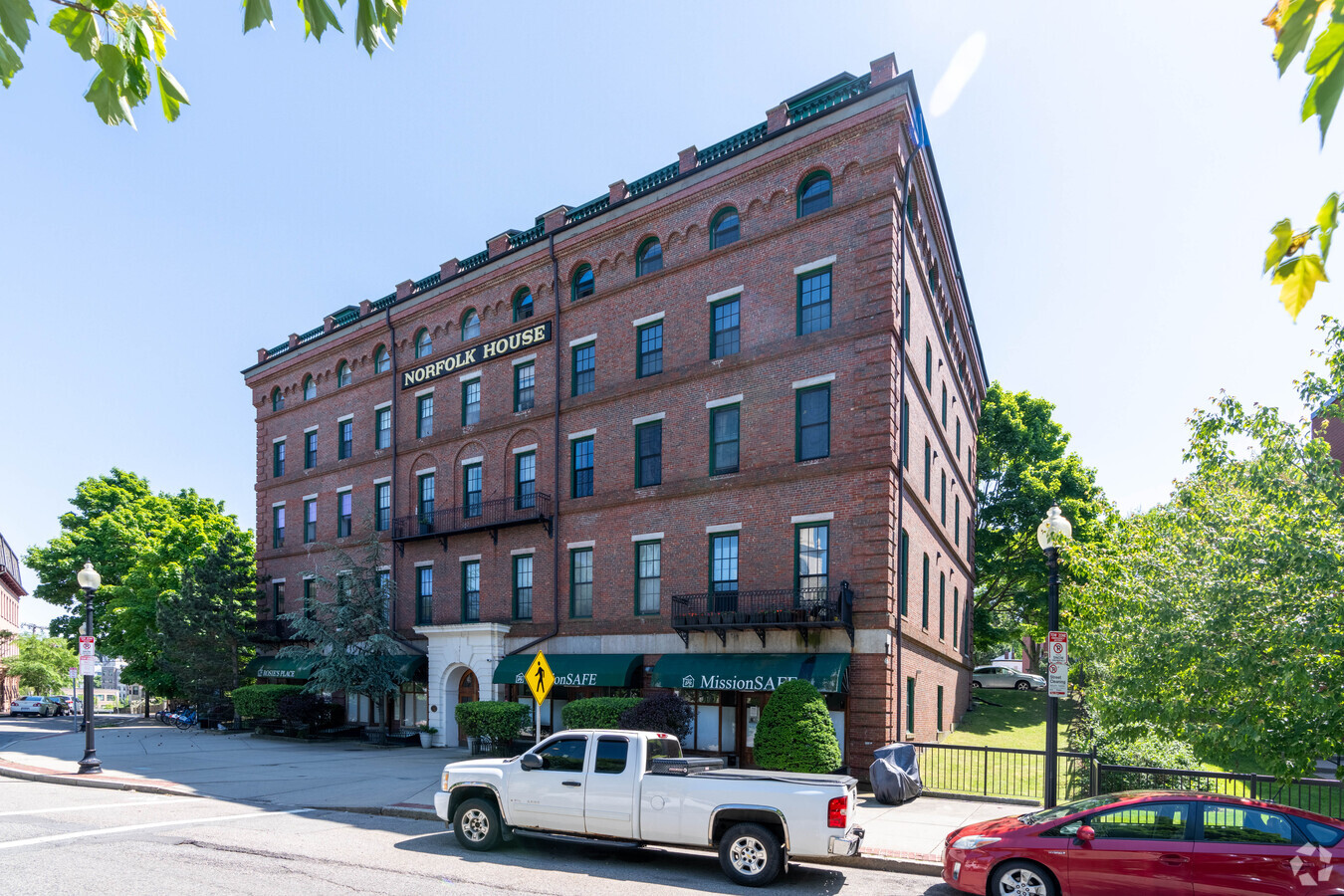
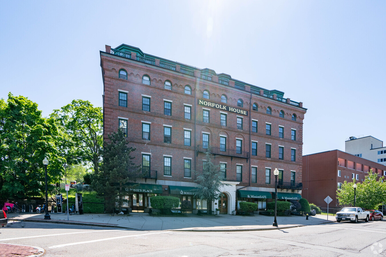
Property Record
10 John Eliot Sq, Roxbury, MA 02119
NEARBY LISTINGS FOR SALE OR LEASE
-
-
-
No Photo
-
-
-
-
-
-
-
-
-
-
-
-
-
-
-
-
-
-
-
-
-
View all Roxbury listings for sale on LoopNet.com
Property Detail
10 John Eliot Sq
ROXB-000000-000009-003573
Norfolk House
Taxexempt
Suffolk
X
Massachusetts
25025C0079J
0.26 AC
0
Highland Park
2024
Boston
081400
Boston-Cambridge-Newton, MA-NH
11,100 SF
DEMOGRAPHICS near 10 John Eliot Sq
1 Mile
3 Mile
5 Mile
2024 Total Population
78,631
503,365
888,405
2029 Population
75,111
485,323
855,866
Pop Growth 2024-2029
(4.48%)
(3.58%)
(3.66%)
Average Age
34
36
37
2024 Total Households
28,120
212,578
371,507
HH Growth 2024-2029
(5.00%)
(3.80%)
(3.91%)
Median Household Inc
$44,403
$84,538
$93,575
Avg Household Size
2.20
2.10
2.20
2024 Avg HH Vehicles
1.00
1.00
1.00
Median Home Value
$737,113
$849,626
$800,411
Median Year Built
1953
1954
1949
Nearby Places
- Restaurants
- Banks
- Shops
- Fitness
- Groceries
PUBLIC TRANSPORTATION
TRANSIT/SUBWAY
Roxbury Crossing Station (Orange Line - Massachusetts Bay Transportation Authority Subway (The T))
DRIVE
WALK
Distance
Roxbury Crossing Station (Orange Line - Massachusetts Bay Transportation Authority Subway (The T))
2 min
7 min
0.4 mi
Jackson Square Station (Orange Line - Massachusetts Bay Transportation Authority Subway (The T))
DRIVE
WALK
Distance
Jackson Square Station (Orange Line - Massachusetts Bay Transportation Authority Subway (The T))
3 min
15 min
0.8 mi
Longwood Medical Area Station (Green Line - E - Massachusetts Bay Transportation Authority Subway (The T))
DRIVE
WALK
Distance
Longwood Medical Area Station (Green Line - E - Massachusetts Bay Transportation Authority Subway (The T))
4 min
16 min
0.8 mi
Museum Of Fine Arts Station (Green Line - E - Massachusetts Bay Transportation Authority Subway (The T))
DRIVE
WALK
Distance
Museum Of Fine Arts Station (Green Line - E - Massachusetts Bay Transportation Authority Subway (The T))
3 min
17 min
0.9 mi
Northeastern University Station (Green Line - E - Massachusetts Bay Transportation Authority Subway (The T))
DRIVE
WALK
Distance
Northeastern University Station (Green Line - E - Massachusetts Bay Transportation Authority Subway (The T))
5 min
20 min
1.0 mi
COMMUTER RAIL
Ruggles Station (Franklin Line - Massachusetts Bay Transportation Authority Commuter Rail (Purple Line), Needham Line - Massachusetts Bay Transportation Authority Commuter Rail (Purple Line), Orange Line - Massachusetts Bay Transportation Authority Commuter Rail (Purple Line), Providence/Stoughton Line - Massachusetts Bay Transportation Authority Commuter Rail (Purple Line))
DRIVE
WALK
Distance
Ruggles Station (Franklin Line - Massachusetts Bay Transportation Authority Commuter Rail (Purple Line), Needham Line - Massachusetts Bay Transportation Authority Commuter Rail (Purple Line), Orange Line - Massachusetts Bay Transportation Authority Commuter Rail (Purple Line), Providence/Stoughton Line - Massachusetts Bay Transportation Authority Commuter Rail (Purple Line))
4 min
14 min
0.8 mi
Newmarket (Fairmount Line - MBTA, Franklin/Foxboro Line - MBTA)
DRIVE
WALK
Distance
Newmarket (Fairmount Line - MBTA, Franklin/Foxboro Line - MBTA)
4 min
1.6 mi
AIRPORT
General Edward Lawrence Logan International
DRIVE
WALK
Distance
General Edward Lawrence Logan International
13 min
6.2 mi
Freight Ports
Port of Boston
DRIVE
WALK
Distance
Port of Boston
11 min
4.5 mi
Nearby Properties
Address
Land Use
TOTAL SIZE
Lot Size
Zoning
Address
Land Use
TOTAL SIZE
Lot Size
Zoning
909,764 SF
25.13 AC
E
Address
Land Use
TOTAL SIZE
Lot Size
Zoning
610,560 SF
4 AC
E
Address
Land Use
TOTAL SIZE
Lot Size
Zoning
707,000 SF
1.60 AC
C
Address
Land Use
TOTAL SIZE
Lot Size
Zoning
2.79 AC
Address
Land Use
TOTAL SIZE
Lot Size
Zoning
488,832 SF
1.38 AC
BB
Address
Land Use
TOTAL SIZE
Lot Size
Zoning
469,670 SF
7.60 AC
C
Address
Land Use
TOTAL SIZE
Lot Size
Zoning
230,394 SF
0.60 AC
MXD
Address
Land Use
TOTAL SIZE
Lot Size
Zoning
448,796 SF
1.84 AC
C
Address
Land Use
TOTAL SIZE
Lot Size
Zoning
342,300 SF
1.04 AC
C
Address
Land Use
TOTAL SIZE
Lot Size
Zoning
239,377 SF
0.71 AC
MXD
Address
Land Use
TOTAL SIZE
Lot Size
Zoning
114,000 SF
1.20 AC
RC
Address
Land Use
TOTAL SIZE
Lot Size
Zoning
46,259 SF
1.04 AC
E
Address
Land Use
TOTAL SIZE
Lot Size
Zoning
379,172 SF
1.04 AC
RC
Address
Land Use
TOTAL SIZE
Lot Size
Zoning
4,355 SF
13.12 AC
E
Address
Land Use
TOTAL SIZE
Lot Size
Zoning
1.13 AC
C
Address
Land Use
TOTAL SIZE
Lot Size
Zoning
2.81 AC
O-2
Address
Land Use
TOTAL SIZE
Lot Size
Zoning
2.25 AC
SD-12
Address
Land Use
TOTAL SIZE
Lot Size
Zoning
157,083 SF
0.41 AC
C
Address
Land Use
TOTAL SIZE
Lot Size
Zoning
227,107 SF
7.70 AC
E
Address
Land Use
TOTAL SIZE
Lot Size
Zoning
334,522 SF
1.26 AC
C
Address
Land Use
TOTAL SIZE
Lot Size
Zoning
341,500 SF
1.18 AC
RC
Address
Land Use
TOTAL SIZE
Lot Size
Zoning
237,928 SF
1.27 AC
C-3
Address
Land Use
TOTAL SIZE
Lot Size
Zoning
262,120 SF
0.62 AC
C
Address
Land Use
TOTAL SIZE
Lot Size
Zoning
325,020 SF
0.62 AC
RC
Address
Land Use
TOTAL SIZE
Lot Size
Zoning
214,398 SF
0.63 AC
BB-CSQ
Address
Land Use
TOTAL SIZE
Lot Size
Zoning
3.52 AC
C-3
Address
Land Use
TOTAL SIZE
Lot Size
Zoning
158,526 SF
1.13 AC
MXD
Address
Land Use
TOTAL SIZE
Lot Size
Zoning
136,025 SF
6.91 AC
C3
Address
Land Use
TOTAL SIZE
Lot Size
Zoning
254,208 SF
3.83 AC
E
Address
Land Use
TOTAL SIZE
Lot Size
Zoning
241,400 SF
0.57 AC
C
The World's #1 Commercial Real Estate Marketplace
Connect with us
© 2025 CoStar Group
The information above has been obtained from sources believed reliable. While we do not doubt its accuracy we have not verified it and make no guarantee, warranty or representation about it. It is your responsibility to independently confirm its accuracy and completeness. Any projections, opinions, assumptions, or estimates used are for example only and do not represent the current or future performance of the property. The value of this transaction to you depends on tax and other factors which should be evaluated by your tax, financial, and legal advisors. You and your advisors should conduct a careful, independent investigation of the property to determine to your satisfaction the suitability of the property for your needs.