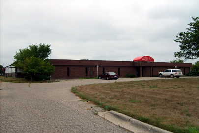
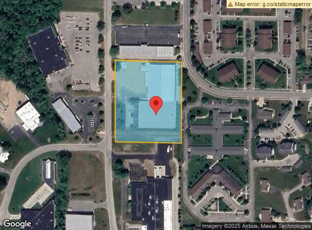
Property Record
100 Applewood Dr, Sparta, MI 49345
NEARBY LISTINGS FOR SALE OR LEASE
-
-
View all Sparta listings for sale on LoopNet.com
Property Detail
100 Applewood Dr
West Michigan
Appletree Industrial Park Plat
Grand Rapids-Wyoming, MI
LOT 16 & N 54 FT OF LOT 15 * APPLETREE INDUSTRIAL PARK PLAT
41-05-22-130-005
Kent
Manufacturinglight
Michigan
2023
15-16
2024
3.88 AC
010402
Outlying Kent County
12,768 SF
DEMOGRAPHICS near 100 Applewood Dr
1 Mile
3 Mile
5 Mile
2024 Total Population
3,456
8,830
16,994
2029 Population
3,515
8,930
17,156
Pop Growth 2024-2029
+ 1.71%
+ 1.13%
+ 0.95%
Average Age
39
39
39
2024 Total Households
1,417
3,428
6,334
HH Growth 2024-2029
+ 1.83%
+ 1.25%
+ 1.01%
Median Household Inc
$60,485
$70,345
$76,977
Avg Household Size
2.40
2.60
2.70
2024 Avg HH Vehicles
2.00
2.00
2.00
Median Home Value
$183,591
$218,580
$247,785
Median Year Built
1965
1976
1980
Nearby Places
- Restaurants
- Banks
- Shops
- Fitness
- Groceries
PUBLIC TRANSPORTATION
AIRPORT
Gerald R Ford International
DRIVE
WALK
Distance
Gerald R Ford International
41 min
28.5 mi
Freight Ports
Port Milwaukee
DRIVE
WALK
Distance
Port Milwaukee
325 min
277.1 mi
Nearby Properties
Address
Land Use
TOTAL SIZE
Lot Size
Zoning
Address
Land Use
TOTAL SIZE
Lot Size
Zoning
132,192 SF
7.36 AC
VR4
Address
Land Use
TOTAL SIZE
Lot Size
Zoning
2,988 SF
52.77 AC
R4
Address
Land Use
TOTAL SIZE
Lot Size
Zoning
131,832 SF
3.81 AC
VLI
Address
Land Use
TOTAL SIZE
Lot Size
Zoning
13,108 SF
4.95 AC
VGC
Address
Land Use
TOTAL SIZE
Lot Size
Zoning
96,781 SF
NONE
Address
Land Use
TOTAL SIZE
Lot Size
Zoning
1,364 SF
70 AC
AG1
Address
Land Use
TOTAL SIZE
Lot Size
Zoning
151,576 SF
17.95 AC
VLI
Address
Land Use
TOTAL SIZE
Lot Size
Zoning
129,961 SF
4.67 AC
VGC
Address
Land Use
TOTAL SIZE
Lot Size
Zoning
78,033 SF
6.68 AC
VLI
Address
Land Use
TOTAL SIZE
Lot Size
Zoning
3,792 SF
37.78 AC
R4
Address
Land Use
TOTAL SIZE
Lot Size
Zoning
45,981 SF
5.22 AC
VLI
Address
Land Use
TOTAL SIZE
Lot Size
Zoning
55,940 SF
AG1
Address
Land Use
TOTAL SIZE
Lot Size
Zoning
55,518 SF
5.25 AC
VGC
Address
Land Use
TOTAL SIZE
Lot Size
Zoning
Address
Land Use
TOTAL SIZE
Lot Size
Zoning
49,380 SF
AG1
Address
Land Use
TOTAL SIZE
Lot Size
Zoning
39,482 SF
3.43 AC
VR4
Address
Land Use
TOTAL SIZE
Lot Size
Zoning
39,911 SF
6.47 AC
VLI
Address
Land Use
TOTAL SIZE
Lot Size
Zoning
15,993 SF
1.17 AC
VCBD
Address
Land Use
TOTAL SIZE
Lot Size
Zoning
114,025 SF
11.50 AC
VLI
Address
Land Use
TOTAL SIZE
Lot Size
Zoning
29.48 AC
R4
Address
Land Use
TOTAL SIZE
Lot Size
Zoning
84,933 SF
3.11 AC
VLI
Address
Land Use
TOTAL SIZE
Lot Size
Zoning
34,480 SF
3.63 AC
VR4
Address
Land Use
TOTAL SIZE
Lot Size
Zoning
84,800 SF
17.36 AC
C2
Address
Land Use
TOTAL SIZE
Lot Size
Zoning
78,145 SF
3.01 AC
VGC
Address
Land Use
TOTAL SIZE
Lot Size
Zoning
25,756 SF
2.57 AC
VGC
Address
Land Use
TOTAL SIZE
Lot Size
Zoning
1,774 SF
18 AC
AG1
Address
Land Use
TOTAL SIZE
Lot Size
Zoning
40 AC
AG1
Address
Land Use
TOTAL SIZE
Lot Size
Zoning
47.35 AC
AG1
Address
Land Use
TOTAL SIZE
Lot Size
Zoning
25,056 SF
1.72 AC
VR4
The World's #1 Commercial Real Estate Marketplace
Connect with us
© 2025 CoStar Group
The information above has been obtained from sources believed reliable. While we do not doubt its accuracy we have not verified it and make no guarantee, warranty or representation about it. It is your responsibility to independently confirm its accuracy and completeness. Any projections, opinions, assumptions, or estimates used are for example only and do not represent the current or future performance of the property. The value of this transaction to you depends on tax and other factors which should be evaluated by your tax, financial, and legal advisors. You and your advisors should conduct a careful, independent investigation of the property to determine to your satisfaction the suitability of the property for your needs.