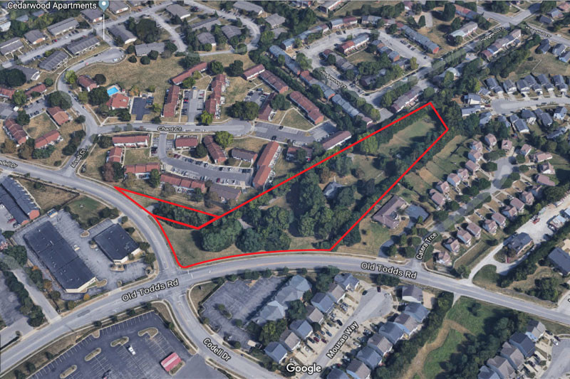
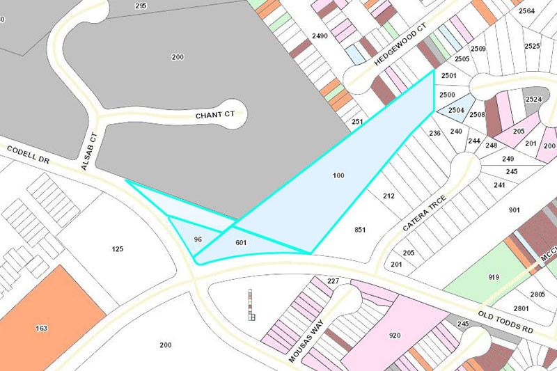
Property Record
100 Codell Dr, Lexington, KY 40509
NEARBY LISTINGS FOR SALE OR LEASE
Property Detail
100 Codell Dr
Lexington-Fayette, KY
Shadowwood Ph Ii
24242100
J-562 SHADOWWOOD PH II & 701 TODDS RD LOT PCL 5; BOOK: 412 PAGE: 288
Apartment
Fayette
X
Kentucky
2100670139E
5
2024
2.81 AC
2024
East Lexington/Fayette
003910
Lexington/Fayette
2,397 SF
DEMOGRAPHICS near 100 Codell Dr
1 Mile
3 Mile
5 Mile
2024 Total Population
12,741
98,071
215,743
2029 Population
12,680
97,893
215,573
Pop Growth 2024-2029
(0.48%)
(0.18%)
(0.08%)
Average Age
36
38
38
2024 Total Households
5,775
42,293
93,241
HH Growth 2024-2029
(0.52%)
(0.25%)
(0.07%)
Median Household Inc
$51,209
$63,051
$57,061
Avg Household Size
2.20
2.20
2.20
2024 Avg HH Vehicles
2.00
2.00
2.00
Median Home Value
$152,478
$287,192
$253,454
Median Year Built
1984
1982
1980
Nearby Places
- Restaurants
- Banks
- Shops
- Fitness
- Groceries
PUBLIC TRANSPORTATION
AIRPORT
Blue Grass
DRIVE
WALK
Distance
Blue Grass
23 min
12.3 mi
Freight Ports
Port of Toledo
DRIVE
WALK
Distance
Port of Toledo
340 min
293.2 mi
SALE & LEASE HISTORY
LISTING DATE
SALE/LEASE

Sep 11, 2019
For Sale
Nearby Properties
Address
Land Use
TOTAL SIZE
Lot Size
Zoning
Address
Land Use
TOTAL SIZE
Lot Size
Zoning
163,323 SF
31 AC
P-1
Address
Land Use
TOTAL SIZE
Lot Size
Zoning
76,441 SF
63.86 AC
A-U
Address
Land Use
TOTAL SIZE
Lot Size
Zoning
301,644 SF
38.07 AC
R-1C
Address
Land Use
TOTAL SIZE
Lot Size
Zoning
7,640 SF
9.04 AC
EAR-3
Address
Land Use
TOTAL SIZE
Lot Size
Zoning
156,270 SF
11.18 AC
R-1C
Address
Land Use
TOTAL SIZE
Lot Size
Zoning
9,746 SF
16.65 AC
R-4
Address
Land Use
TOTAL SIZE
Lot Size
Zoning
163,828 SF
17.69 AC
P-1
Address
Land Use
TOTAL SIZE
Lot Size
Zoning
24,174 SF
15.02 AC
R-3
Address
Land Use
TOTAL SIZE
Lot Size
Zoning
19 AC
R-3
Address
Land Use
TOTAL SIZE
Lot Size
Zoning
17.20 AC
R-4
Address
Land Use
TOTAL SIZE
Lot Size
Zoning
8,208 SF
21.16 AC
R-3
Address
Land Use
TOTAL SIZE
Lot Size
Zoning
9,434 SF
16.28 AC
R-3
Address
Land Use
TOTAL SIZE
Lot Size
Zoning
64,617 SF
41.63 AC
B-6P
Address
Land Use
TOTAL SIZE
Lot Size
Zoning
18.69 AC
R-3
Address
Land Use
TOTAL SIZE
Lot Size
Zoning
5,815 SF
18.51 AC
EAR-2
Address
Land Use
TOTAL SIZE
Lot Size
Zoning
129 AC
ED
Address
Land Use
TOTAL SIZE
Lot Size
Zoning
57,974 SF
15.22 AC
B-6P
Address
Land Use
TOTAL SIZE
Lot Size
Zoning
28,776 SF
13.82 AC
B-1
Address
Land Use
TOTAL SIZE
Lot Size
Zoning
73,590 SF
13.31 AC
R-1T
Address
Land Use
TOTAL SIZE
Lot Size
Zoning
13.77 AC
R-4
Address
Land Use
TOTAL SIZE
Lot Size
Zoning
103,445 SF
18.39 AC
A-U
Address
Land Use
TOTAL SIZE
Lot Size
Zoning
267,060 SF
65 AC
R-3
Address
Land Use
TOTAL SIZE
Lot Size
Zoning
4,406 SF
28.12 AC
R-3
Address
Land Use
TOTAL SIZE
Lot Size
Zoning
4,868 SF
15.41 AC
R-3
Address
Land Use
TOTAL SIZE
Lot Size
Zoning
42,642 SF
10.35 AC
B-6P
Address
Land Use
TOTAL SIZE
Lot Size
Zoning
25,608 SF
104.39 AC
I-1
Address
Land Use
TOTAL SIZE
Lot Size
Zoning
53,543 SF
9.78 AC
R-1C
Address
Land Use
TOTAL SIZE
Lot Size
Zoning
147,967 SF
17.03 AC
CC
Address
Land Use
TOTAL SIZE
Lot Size
Zoning
39,672 SF
46.50 AC
R-1B
Address
Land Use
TOTAL SIZE
Lot Size
Zoning
389.88 AC
A-U
The World's #1 Commercial Real Estate Marketplace
Connect with us
© 2025 CoStar Group
The information above has been obtained from sources believed reliable. While we do not doubt its accuracy we have not verified it and make no guarantee, warranty or representation about it. It is your responsibility to independently confirm its accuracy and completeness. Any projections, opinions, assumptions, or estimates used are for example only and do not represent the current or future performance of the property. The value of this transaction to you depends on tax and other factors which should be evaluated by your tax, financial, and legal advisors. You and your advisors should conduct a careful, independent investigation of the property to determine to your satisfaction the suitability of the property for your needs.