Property Record
100 Guest St, Brighton, MA 02135
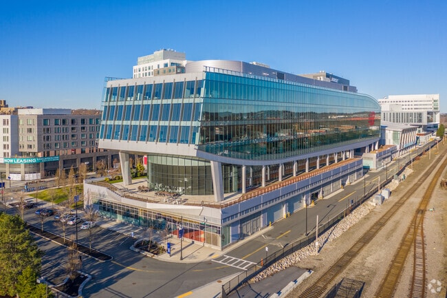

Property Detail
100 Guest St
Officebuilding
Suffolk
C
Massachusetts
B and X Area of moderate flood hazard, usually the area between the limits of the 100-year and 500-year floods.
2.75 AC
2025
Allston/Brighton
2025
Boston
000102
Boston-Cambridge-Newton, MA-NH
506,534 SF
BRIG-000000-000022-001905-000030
NEARBY LISTINGS FOR SALE OR LEASE
DEMOGRAPHICS near 100 Guest St
1 mile
3 mile
5 mile
2025 Total Population
48,697
412,195
940,634
2030 Population
50,258
424,894
969,692
Pop Growth 2025-2030
+ 3.21%
+ 3.08%
+ 3.09%
Average Age
34
36
38
2025 Total Households
21,362
168,509
392,379
HH Growth 2025-2030
+ 3.50%
+ 3.50%
+ 3.42%
Median Household Inc
$83,647
$110,731
$117,038
Avg Household Size
2.20
2.10
2.10
2025 Avg HH Vehicles
1.00
1.00
1.00
Median Home Value
$705,606
$1,010,535
$944,407
Median Year Built
1961
1949
1949
Nearby Places
Map Layers
Map Styles
 Street
 Aerial
Layers
 Traffic
 Biking
Places
Listings with unknown addresses are not visible on the map
- Restaurants
- Banks
- Shops
- Fitness
- Groceries
PUBLIC TRANSPORTATION
TRANSIT/SUBWAY
Warren Street Station (Green Line - B - Massachusetts Bay Transportation Authority Subway (The T))
Drive
Walk
Distance
Warren Street Station (Green Line - B - Massachusetts Bay Transportation Authority Subway (The T))
3 min
14 min
0.8 mi
Allston Street Station (Green Line - B - Massachusetts Bay Transportation Authority Subway (The T))
Drive
Walk
Distance
Allston Street Station (Green Line - B - Massachusetts Bay Transportation Authority Subway (The T))
3 min
16 min
0.8 mi
Harvard Avenue Station (Green Line - B - Massachusetts Bay Transportation Authority Subway (The T))
Drive
Walk
Distance
Harvard Avenue Station (Green Line - B - Massachusetts Bay Transportation Authority Subway (The T))
3 min
18 min
1.0 mi
Griggs Street/Long Avenue Station (Green Line - B - Massachusetts Bay Transportation Authority Subway (The T))
Drive
Walk
Distance
Griggs Street/Long Avenue Station (Green Line - B - Massachusetts Bay Transportation Authority Subway (The T))
3 min
18 min
1.0 mi
COMMUTER RAIL
Boston Landing (Framingham/Worcester Line - MBTA)
Drive
Walk
Distance
Boston Landing (Framingham/Worcester Line - MBTA)
10 min
3 min
0.2 mi
Yawkey (Framingham/Worcester Line - Massachusetts Bay Transportation Authority Commuter Rail (Purple Line))
Drive
Walk
Distance
Yawkey (Framingham/Worcester Line - Massachusetts Bay Transportation Authority Commuter Rail (Purple Line))
6 min
2.8 mi
AIRPORT
General Edward Lawrence Logan International
Drive
Walk
Distance
General Edward Lawrence Logan International
16 min
8.7 mi
Freight Ports
Port of Boston
Drive
Walk
Distance
Port of Boston
15 min
7.1 mi
SALE & LEASE HISTORY
LISTING DATE
SALE/LEASE

Sep 25, 2016
For Lease
Nearby Properties
Address
Land Use
TOTAL SIZE
Lot Size
Zoning
Address
Land Use
TOTAL SIZE
Lot Size
Zoning
439,500 SF
9.21 AC
E
Address
Land Use
TOTAL SIZE
Lot Size
Zoning
125,571 SF
3.25 AC
C-3
Address
Land Use
TOTAL SIZE
Lot Size
Zoning
150,192 SF
10.27 AC
E
Address
Land Use
TOTAL SIZE
Lot Size
Zoning
596,972 SF
7.32 AC
E
Address
Land Use
TOTAL SIZE
Lot Size
Zoning
530,200 SF
62.08 AC
E
Address
Land Use
TOTAL SIZE
Lot Size
Zoning
173,400 SF
1.14 AC
MXD
Address
Land Use
TOTAL SIZE
Lot Size
Zoning
142,458 SF
1.67 AC
C-3
Address
Land Use
TOTAL SIZE
Lot Size
Zoning
230,394 SF
0.60 AC
MXD
Address
Land Use
TOTAL SIZE
Lot Size
Zoning
304,349 SF
1.72 AC
Address
Land Use
TOTAL SIZE
Lot Size
Zoning
3.52 AC
C-3
Address
Land Use
TOTAL SIZE
Lot Size
Zoning
377,634 SF
4.86 AC
E
Address
Land Use
TOTAL SIZE
Lot Size
Zoning
239,377 SF
0.71 AC
MXD
Address
Land Use
TOTAL SIZE
Lot Size
Zoning
419,722 SF
2.03 AC
RC
Address
Land Use
TOTAL SIZE
Lot Size
Zoning
283,554 SF
2.76 AC
O-2A
Address
Land Use
TOTAL SIZE
Lot Size
Zoning
54,500 SF
4.01 AC
O-2A
Address
Land Use
TOTAL SIZE
Lot Size
Zoning
2.81 AC
O-2
Address
Land Use
TOTAL SIZE
Lot Size
Zoning
254,208 SF
3.83 AC
E
Address
Land Use
TOTAL SIZE
Lot Size
Zoning
4,355 SF
13.12 AC
E
Address
Land Use
TOTAL SIZE
Lot Size
Zoning
237,935 SF
1.27 AC
C-3
Address
Land Use
TOTAL SIZE
Lot Size
Zoning
336,518 SF
6.15 AC
I-3
Address
Land Use
TOTAL SIZE
Lot Size
Zoning
2.87 AC
O-2A
Address
Land Use
TOTAL SIZE
Lot Size
Zoning
155,818 SF
5.33 AC
OS
Address
Land Use
TOTAL SIZE
Lot Size
Zoning
220,671 SF
2.52 AC
I-2
Address
Land Use
TOTAL SIZE
Lot Size
Zoning
213,834 SF
1.48 AC
SD-4
Address
Land Use
TOTAL SIZE
Lot Size
Zoning
136,025 SF
6.91 AC
C3
Address
Land Use
TOTAL SIZE
Lot Size
Zoning
2.25 AC
SD-12
Address
Land Use
TOTAL SIZE
Lot Size
Zoning
224,115 SF
2.35 AC
O-2A
Address
Land Use
TOTAL SIZE
Lot Size
Zoning
158,526 SF
0.79 AC
MXD
Address
Land Use
TOTAL SIZE
Lot Size
Zoning
244,008 SF
4 AC
SD-4A
The World's #1 Commercial Real Estate Marketplace
Connect with us
© 2026 CoStar Group
The information above has been obtained from sources believed reliable. While we do not doubt its accuracy we have not verified it and make no guarantee, warranty or representation about it. It is your responsibility to independently confirm its accuracy and completeness. Any projections, opinions, assumptions, or estimates used are for example only and do not represent the current or future performance of the property. The value of this transaction to you depends on tax and other factors which should be evaluated by your tax, financial, and legal advisors. You and your advisors should conduct a careful, independent investigation of the property to determine to your satisfaction the suitability of the property for your needs.