Property Record
100 Gulf Breeze Ave, Punta Gorda, FL 33950


NEARBY LISTINGS FOR SALE OR LEASE
-
-
View all Punta Gorda listings for sale on LoopNet.com
Property Detail
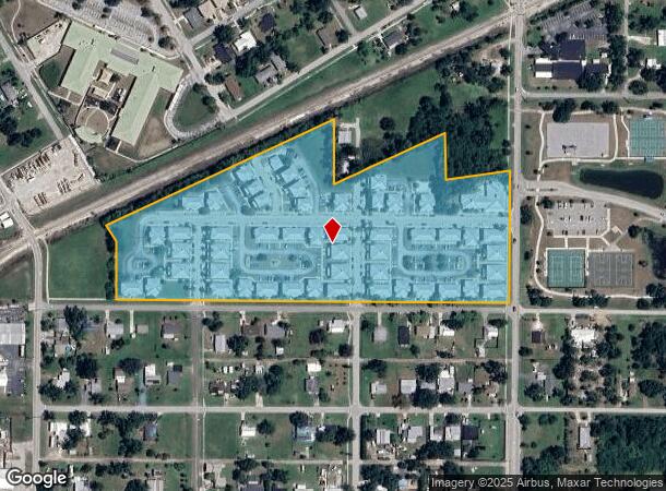
100 Gulf Breeze Ave
412306485007
06 41 23 P-1 14 AC M/L THAT PART OF SE1/4 OF SE1/4 LYING S OF ACL RR R/W W OF COOPER ST LESS FOUR 1/AC TRACTS FRONTING ON RR ON COOPER STREET SIDE AKA TRACTS 1 THRU 6 GULF BREEZES APARTMENTS AS PER PB21 PG 10 316/815 589/1173 E3176/1304 RES
Multifamilydwelling
Charlotte
AE
Florida
12015C0241G
12.34 AC
2023
Punta Gorda
2023
Southwest Florida
010302
Punta Gorda, FL
204,224 SF
DEMOGRAPHICS near 100 Gulf Breeze Ave
1 Mile
3 Mile
5 Mile
2024 Total Population
5,385
25,658
63,052
2029 Population
6,548
30,961
75,831
Pop Growth 2024-2029
+ 21.60%
+ 20.67%
+ 20.27%
Average Age
48
58
55
2024 Total Households
2,583
12,846
30,071
HH Growth 2024-2029
+ 21.72%
+ 20.82%
+ 20.58%
Median Household Inc
$38,350
$58,514
$57,711
Avg Household Size
2.00
1.90
2.00
2024 Avg HH Vehicles
1.00
2.00
2.00
Median Home Value
$225,161
$376,574
$274,424
Median Year Built
1990
1991
1989
Nearby Places
- Restaurants
- Banks
- Shops
- Fitness
- Groceries
PUBLIC TRANSPORTATION
AIRPORT
Punta Gorda
DRIVE
WALK
Distance
Punta Gorda
9 min
4.0 mi
Freight Ports
Port Manatee
DRIVE
WALK
Distance
Port Manatee
86 min
72.6 mi
Nearby Properties
Address
Land Use
TOTAL SIZE
Lot Size
Zoning
Address
Land Use
TOTAL SIZE
Lot Size
Zoning
333,027 SF
9.79 AC
CHRW
Address
Land Use
TOTAL SIZE
Lot Size
Zoning
349,844 SF
78.47 AC
P
Address
Land Use
TOTAL SIZE
Lot Size
Zoning
163,527 SF
44.20 AC
ECAP
Address
Land Use
TOTAL SIZE
Lot Size
Zoning
77,154 SF
10.30 AC
PD-P
Address
Land Use
TOTAL SIZE
Lot Size
Zoning
161,439 SF
171 AC
RE1
Address
Land Use
TOTAL SIZE
Lot Size
Zoning
345,043 SF
33.12 AC
ECAP
Address
Land Use
TOTAL SIZE
Lot Size
Zoning
47,443 SF
7.94 AC
CC
Address
Land Use
TOTAL SIZE
Lot Size
Zoning
15,253 SF
13.27 AC
P
Address
Land Use
TOTAL SIZE
Lot Size
Zoning
134,308 SF
16 AC
RSF3.5
Address
Land Use
TOTAL SIZE
Lot Size
Zoning
142,812 SF
7.89 AC
HC
Address
Land Use
TOTAL SIZE
Lot Size
Zoning
6,313 SF
15.49 AC
P
Address
Land Use
TOTAL SIZE
Lot Size
Zoning
208,560 SF
36.69 AC
PD-GM
Address
Land Use
TOTAL SIZE
Lot Size
Zoning
279,650 SF
374.81 AC
ECAP
Address
Land Use
TOTAL SIZE
Lot Size
Zoning
73,095 SF
5 AC
NC
Address
Land Use
TOTAL SIZE
Lot Size
Zoning
9,118 SF
13.57 AC
P
Address
Land Use
TOTAL SIZE
Lot Size
Zoning
31,608 SF
8.02 AC
NC
Address
Land Use
TOTAL SIZE
Lot Size
Zoning
128,594 SF
25.95 AC
PD
Address
Land Use
TOTAL SIZE
Lot Size
Zoning
30,472 SF
3.19 AC
NR-10
Address
Land Use
TOTAL SIZE
Lot Size
Zoning
24,580 SF
84.50 AC
PKR
Address
Land Use
TOTAL SIZE
Lot Size
Zoning
30,940 SF
0.42 AC
NC
Address
Land Use
TOTAL SIZE
Lot Size
Zoning
12,159 SF
0.56 AC
PD-CC
Address
Land Use
TOTAL SIZE
Lot Size
Zoning
68,492 SF
6.38 AC
HC
Address
Land Use
TOTAL SIZE
Lot Size
Zoning
43,914 SF
4.06 AC
HC
Address
Land Use
TOTAL SIZE
Lot Size
Zoning
49,958 SF
6.81 AC
CC
Address
Land Use
TOTAL SIZE
Lot Size
Zoning
82,379 SF
0.88 AC
CC
Address
Land Use
TOTAL SIZE
Lot Size
Zoning
43,755 SF
8.18 AC
CC
Address
Land Use
TOTAL SIZE
Lot Size
Zoning
25,356 SF
1.40 AC
CC
Address
Land Use
TOTAL SIZE
Lot Size
Zoning
70,518 SF
2.08 AC
CG
Address
Land Use
TOTAL SIZE
Lot Size
Zoning
54.25 AC
RMF10
Address
Land Use
TOTAL SIZE
Lot Size
Zoning
63,902 SF
5.87 AC
HC
The World's #1 Commercial Real Estate Marketplace
Connect with us
© 2025 CoStar Group
The information above has been obtained from sources believed reliable. While we do not doubt its accuracy we have not verified it and make no guarantee, warranty or representation about it. It is your responsibility to independently confirm its accuracy and completeness. Any projections, opinions, assumptions, or estimates used are for example only and do not represent the current or future performance of the property. The value of this transaction to you depends on tax and other factors which should be evaluated by your tax, financial, and legal advisors. You and your advisors should conduct a careful, independent investigation of the property to determine to your satisfaction the suitability of the property for your needs.