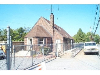
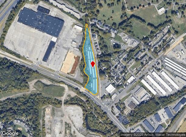
Property Record
100 Hickman Rd, Claymont, DE 19703
NEARBY LISTINGS FOR SALE OR LEASE
-
-
View all Claymont listings for sale on LoopNet.com
Property Detail
100 Hickman Rd
06-048.00-026
Naamans Sta Mini Sto
Officebuilding
New Castle
AE
Delaware
10003C0079K
5.47 AC
2024
North New Castle County
2024
Philadelphia
010105
Philadelphia-Camden-Wilmington, PA-NJ-DE-MD
50,731 SF
DEMOGRAPHICS near 100 Hickman Rd
1 Mile
3 Mile
5 Mile
2024 Total Population
7,405
61,808
149,627
2029 Population
7,471
61,944
150,162
Pop Growth 2024-2029
+ 0.89%
+ 0.22%
+ 0.36%
Average Age
38
41
41
2024 Total Households
3,232
25,404
58,896
HH Growth 2024-2029
+ 0.93%
+ 0.27%
+ 0.39%
Median Household Inc
$67,343
$73,072
$76,643
Avg Household Size
2.20
2.40
2.50
2024 Avg HH Vehicles
1.00
2.00
2.00
Median Home Value
$217,912
$265,814
$298,977
Median Year Built
1973
1965
1964
Nearby Places
- Restaurants
- Banks
- Shops
- Fitness
- Groceries
PUBLIC TRANSPORTATION
COMMUTER RAIL
Claymont (R2 - Southeastern Pennsylvania Transportation Authority Regional Rail (SEPTA Regional Rail))
DRIVE
WALK
Distance
Claymont (R2 - Southeastern Pennsylvania Transportation Authority Regional Rail (SEPTA Regional Rail))
7 min
2.3 mi
Marcus Hook (R2 - Southeastern Pennsylvania Transportation Authority Regional Rail (SEPTA Regional Rail))
DRIVE
WALK
Distance
Marcus Hook (R2 - Southeastern Pennsylvania Transportation Authority Regional Rail (SEPTA Regional Rail))
6 min
2.4 mi
AIRPORT
Philadelphia International
DRIVE
WALK
Distance
Philadelphia International
21 min
13.3 mi
Freight Ports
Port of Wilmington, RI
DRIVE
WALK
Distance
Port of Wilmington, RI
17 min
10.7 mi
Nearby Properties
Address
Land Use
TOTAL SIZE
Lot Size
Zoning
Address
Land Use
TOTAL SIZE
Lot Size
Zoning
Address
Land Use
TOTAL SIZE
Lot Size
Zoning
26,424 SF
341 AC
Address
Land Use
TOTAL SIZE
Lot Size
Zoning
36.50 AC
Address
Land Use
TOTAL SIZE
Lot Size
Zoning
164,862 SF
10.70 AC
Address
Land Use
TOTAL SIZE
Lot Size
Zoning
15,880 SF
27.07 AC
Address
Land Use
TOTAL SIZE
Lot Size
Zoning
23,179 SF
2 AC
Address
Land Use
TOTAL SIZE
Lot Size
Zoning
208,352 SF
21 AC
Address
Land Use
TOTAL SIZE
Lot Size
Zoning
95,760 SF
20 AC
Address
Land Use
TOTAL SIZE
Lot Size
Zoning
22,140 SF
16 AC
Address
Land Use
TOTAL SIZE
Lot Size
Zoning
401,000 SF
10 AC
Address
Land Use
TOTAL SIZE
Lot Size
Zoning
10,716 SF
14.34 AC
Address
Land Use
TOTAL SIZE
Lot Size
Zoning
5,626 SF
54.24 AC
Address
Land Use
TOTAL SIZE
Lot Size
Zoning
5,812 SF
72.63 AC
Address
Land Use
TOTAL SIZE
Lot Size
Zoning
131,812 SF
20.70 AC
Address
Land Use
TOTAL SIZE
Lot Size
Zoning
11,146 SF
21.82 AC
Address
Land Use
TOTAL SIZE
Lot Size
Zoning
197,332 SF
12.13 AC
S
Address
Land Use
TOTAL SIZE
Lot Size
Zoning
122,819 SF
21.23 AC
S
Address
Land Use
TOTAL SIZE
Lot Size
Zoning
171,500 SF
12.93 AC
Address
Land Use
TOTAL SIZE
Lot Size
Zoning
560 SF
298.31 AC
Address
Land Use
TOTAL SIZE
Lot Size
Zoning
240,690 SF
18.44 AC
NCAP
Address
Land Use
TOTAL SIZE
Lot Size
Zoning
44,200 SF
9.30 AC
Address
Land Use
TOTAL SIZE
Lot Size
Zoning
166,216 SF
5.01 AC
NCAP
Address
Land Use
TOTAL SIZE
Lot Size
Zoning
141,066 SF
36.52 AC
S
Address
Land Use
TOTAL SIZE
Lot Size
Zoning
231.88 AC
RFI
Address
Land Use
TOTAL SIZE
Lot Size
Zoning
162,420 SF
8 AC
Address
Land Use
TOTAL SIZE
Lot Size
Zoning
210,681 SF
36.36 AC
CR
Address
Land Use
TOTAL SIZE
Lot Size
Zoning
324,733 SF
17.70 AC
NCAP
Address
Land Use
TOTAL SIZE
Lot Size
Zoning
54,000 SF
9.58 AC
Address
Land Use
TOTAL SIZE
Lot Size
Zoning
212,990 SF
13.69 AC
S
Address
Land Use
TOTAL SIZE
Lot Size
Zoning
297,108 SF
5.74 AC
NCAP
The World's #1 Commercial Real Estate Marketplace
Connect with us
© 2025 CoStar Group
The information above has been obtained from sources believed reliable. While we do not doubt its accuracy we have not verified it and make no guarantee, warranty or representation about it. It is your responsibility to independently confirm its accuracy and completeness. Any projections, opinions, assumptions, or estimates used are for example only and do not represent the current or future performance of the property. The value of this transaction to you depends on tax and other factors which should be evaluated by your tax, financial, and legal advisors. You and your advisors should conduct a careful, independent investigation of the property to determine to your satisfaction the suitability of the property for your needs.