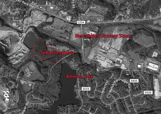
Property Record
100 Laurel Oak Dr, Candler, NC 28715
NEARBY LISTINGS FOR SALE OR LEASE
-
-
View all Candler listings for sale on LoopNet.com
Property Detail
100 Laurel Oak Dr
9617-00-7901-00000
Biltmore Farms
Apartment
SUBDIV: BILTMORE FARMS PLAT: 0082-0095
AE
Buncombe
3700961700J
North Carolina
2023
33.25 AC
2023
Buncombe County
002402
Asheville
103,898 SF
Asheville, NC
DEMOGRAPHICS near 100 Laurel Oak Dr
1 Mile
3 Mile
5 Mile
2024 Total Population
3,630
21,910
51,044
2029 Population
3,784
22,710
52,728
Pop Growth 2024-2029
+ 4.24%
+ 3.65%
+ 3.30%
Average Age
42
42
41
2024 Total Households
1,537
9,160
21,406
HH Growth 2024-2029
+ 3.77%
+ 3.13%
+ 2.74%
Median Household Inc
$67,764
$69,578
$64,049
Avg Household Size
2.30
2.30
2.30
2024 Avg HH Vehicles
2.00
2.00
2.00
Median Home Value
$378,086
$306,560
$301,686
Median Year Built
1996
1992
1986
Nearby Places
- Restaurants
- Banks
- Shops
- Fitness
- Groceries
PUBLIC TRANSPORTATION
AIRPORT
Asheville Regional
DRIVE
WALK
Distance
Asheville Regional
22 min
15.4 mi
Freight Ports
North Charleston Terminal
DRIVE
WALK
Distance
North Charleston Terminal
293 min
259.1 mi
Nearby Properties
Address
Land Use
TOTAL SIZE
Lot Size
Zoning
Address
Land Use
TOTAL SIZE
Lot Size
Zoning
134,180 SF
60.94 AC
PS
Address
Land Use
TOTAL SIZE
Lot Size
Zoning
164,080 SF
140.05 AC
PS
Address
Land Use
TOTAL SIZE
Lot Size
Zoning
151,884 SF
129.72 AC
Address
Land Use
TOTAL SIZE
Lot Size
Zoning
79,908 SF
60 AC
PS
Address
Land Use
TOTAL SIZE
Lot Size
Zoning
131,946 SF
13.28 AC
EMP
Address
Land Use
TOTAL SIZE
Lot Size
Zoning
75,988 SF
12.90 AC
PS
Address
Land Use
TOTAL SIZE
Lot Size
Zoning
126,508 SF
14.90 AC
EMP
Address
Land Use
TOTAL SIZE
Lot Size
Zoning
61,548 SF
8.95 AC
OU
Address
Land Use
TOTAL SIZE
Lot Size
Zoning
88,306 SF
10.29 AC
CS
Address
Land Use
TOTAL SIZE
Lot Size
Zoning
43,285 SF
7.88 AC
R-2
Address
Land Use
TOTAL SIZE
Lot Size
Zoning
94,560 SF
13.52 AC
PS
Address
Land Use
TOTAL SIZE
Lot Size
Zoning
126,826 SF
19.01 AC
HB
Address
Land Use
TOTAL SIZE
Lot Size
Zoning
56,400 SF
7.46 AC
OU
Address
Land Use
TOTAL SIZE
Lot Size
Zoning
33,621 SF
12.19 AC
R-1
Address
Land Use
TOTAL SIZE
Lot Size
Zoning
34,752 SF
9.33 AC
R-1
Address
Land Use
TOTAL SIZE
Lot Size
Zoning
1,236,136 SF
52.82 AC
IND
Address
Land Use
TOTAL SIZE
Lot Size
Zoning
76,939 SF
6.48 AC
EMP
Address
Land Use
TOTAL SIZE
Lot Size
Zoning
63,620 SF
27.35 AC
OU
Address
Land Use
TOTAL SIZE
Lot Size
Zoning
32,965 SF
11.66 AC
OU
Address
Land Use
TOTAL SIZE
Lot Size
Zoning
19,812 SF
8.24 AC
R-1
Address
Land Use
TOTAL SIZE
Lot Size
Zoning
11,452 SF
6.83 AC
R-LD
Address
Land Use
TOTAL SIZE
Lot Size
Zoning
30,878 SF
22.96 AC
IND
Address
Land Use
TOTAL SIZE
Lot Size
Zoning
9.35 AC
CS
Address
Land Use
TOTAL SIZE
Lot Size
Zoning
138.94 AC
OU
Address
Land Use
TOTAL SIZE
Lot Size
Zoning
11,045 SF
1.50 AC
CS
Address
Land Use
TOTAL SIZE
Lot Size
Zoning
66,913 SF
11 AC
IND
Address
Land Use
TOTAL SIZE
Lot Size
Zoning
20,434 SF
12.98 AC
R-1
Address
Land Use
TOTAL SIZE
Lot Size
Zoning
11,778 SF
2.70 AC
R-3
Address
Land Use
TOTAL SIZE
Lot Size
Zoning
20,770 SF
3.66 AC
CS
The World's #1 Commercial Real Estate Marketplace
Connect with us
© 2025 CoStar Group
The information above has been obtained from sources believed reliable. While we do not doubt its accuracy we have not verified it and make no guarantee, warranty or representation about it. It is your responsibility to independently confirm its accuracy and completeness. Any projections, opinions, assumptions, or estimates used are for example only and do not represent the current or future performance of the property. The value of this transaction to you depends on tax and other factors which should be evaluated by your tax, financial, and legal advisors. You and your advisors should conduct a careful, independent investigation of the property to determine to your satisfaction the suitability of the property for your needs.