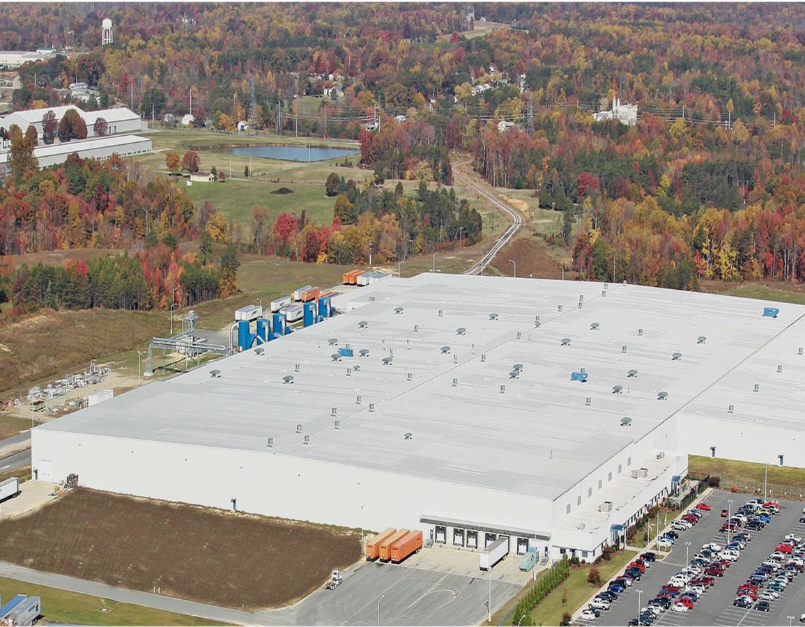
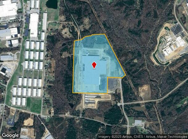
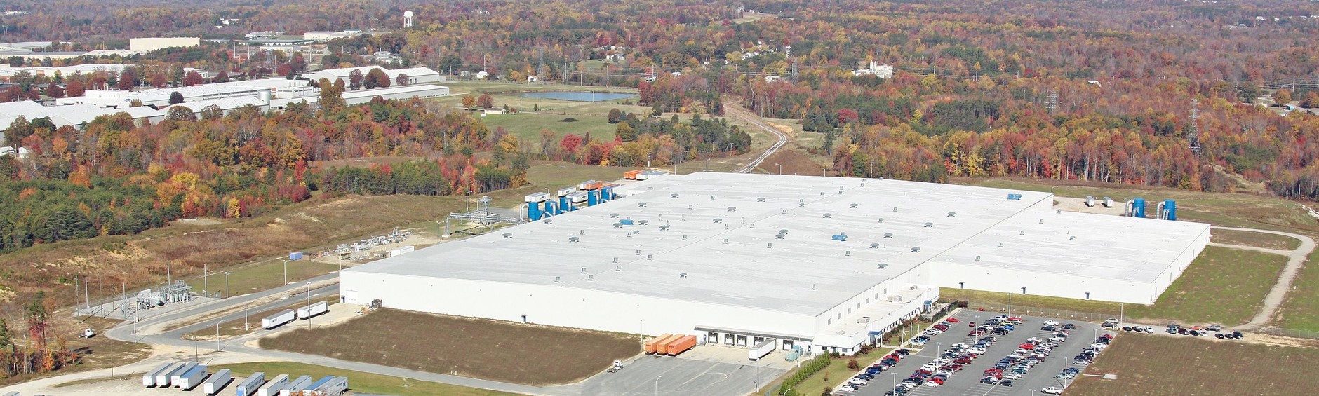
Property Record
100 Morgan Olson Way, Ringgold, VA 24586
NEARBY LISTINGS FOR SALE OR LEASE
Property Detail
100 Morgan Olson Way
Danville, VA
Containing 87
2347-06-3528
CANE CREEK CENTRE LOT 7A
Industrialgeneral
Pittsylvania
AE
Virginia
51143C0654E
7a
2024
87.04 AC
2024
Virginia South Central
011400
Other Market Areas
DEMOGRAPHICS near 100 Morgan Olson Way
1 Mile
3 Mile
5 Mile
2024 Total Population
835
6,606
32,811
2029 Population
806
6,524
32,611
Pop Growth 2024-2029
(3.47%)
(1.24%)
(0.61%)
Average Age
44
42
43
2024 Total Households
422
2,893
14,538
HH Growth 2024-2029
(3.55%)
(1.31%)
(0.61%)
Median Household Inc
$37,833
$33,947
$37,383
Avg Household Size
2.00
2.20
2.10
2024 Avg HH Vehicles
2.00
2.00
2.00
Median Home Value
$97,282
$91,985
$92,630
Median Year Built
1972
1971
1962
Nearby Places
- Restaurants
- Banks
- Shops
- Fitness
- Groceries
PUBLIC TRANSPORTATION
COMMUTER RAIL
Danville Amtrak Station (Crescent - Amtrak)
DRIVE
WALK
Distance
Danville Amtrak Station (Crescent - Amtrak)
13 min
5.8 mi
Freight Ports
Virginia Port Authority - Richmond
DRIVE
WALK
Distance
Virginia Port Authority - Richmond
184 min
138.3 mi
SALE & LEASE HISTORY
LISTING DATE
SALE/LEASE

Oct 16, 2019
For Sale
Nearby Properties
Address
Land Use
TOTAL SIZE
Lot Size
Zoning
Address
Land Use
TOTAL SIZE
Lot Size
Zoning
23.16 AC
M-1
Address
Land Use
TOTAL SIZE
Lot Size
Zoning
1,440 SF
75.14 AC
LIGHT ECON
Address
Land Use
TOTAL SIZE
Lot Size
Zoning
485,973 SF
135.71 AC
MANUFACTUR
Address
Land Use
TOTAL SIZE
Lot Size
Zoning
66,846 SF
22.99 AC
CYBER PARK
Address
Land Use
TOTAL SIZE
Lot Size
Zoning
23.30 AC
M-1
Address
Land Use
TOTAL SIZE
Lot Size
Zoning
7,554 SF
961.50 AC
LIGHT ECON
Address
Land Use
TOTAL SIZE
Lot Size
Zoning
2,421 SF
14.29 AC
LIGHT ECON
Address
Land Use
TOTAL SIZE
Lot Size
Zoning
241,200 SF
55.54 AC
M-1
Address
Land Use
TOTAL SIZE
Lot Size
Zoning
833,039 SF
66.18 AC
MANUFACTUR
Address
Land Use
TOTAL SIZE
Lot Size
Zoning
205,652 SF
7.12 AC
LIGHT ECON
Address
Land Use
TOTAL SIZE
Lot Size
Zoning
312,528 SF
23.32 AC
M-1
Address
Land Use
TOTAL SIZE
Lot Size
Zoning
93,442 SF
11.94 AC
CYBER PARK
Address
Land Use
TOTAL SIZE
Lot Size
Zoning
420 SF
40.78 AC
LIGHT ECON
Address
Land Use
TOTAL SIZE
Lot Size
Zoning
51.53 AC
M-1
Address
Land Use
TOTAL SIZE
Lot Size
Zoning
6,664 SF
102.20 AC
MANUFACTUR
Address
Land Use
TOTAL SIZE
Lot Size
Zoning
162 SF
87 AC
HIGHWAY RE
Address
Land Use
TOTAL SIZE
Lot Size
Zoning
25.05 AC
M-2
Address
Land Use
TOTAL SIZE
Lot Size
Zoning
77,004 SF
22.58 AC
THRESHOLD
Address
Land Use
TOTAL SIZE
Lot Size
Zoning
37,137 SF
22.24 AC
MULTI-FAMI
Address
Land Use
TOTAL SIZE
Lot Size
Zoning
42,244 SF
6.10 AC
MULTI-FAMI
Address
Land Use
TOTAL SIZE
Lot Size
Zoning
62,336 SF
16.65 AC
CYBER PARK
Address
Land Use
TOTAL SIZE
Lot Size
Zoning
85,041 SF
10 AC
CYBER PARK
Address
Land Use
TOTAL SIZE
Lot Size
Zoning
301,800 SF
41.47 AC
LIGHT ECON
Address
Land Use
TOTAL SIZE
Lot Size
Zoning
150,000 SF
23.41 AC
M-1
Address
Land Use
TOTAL SIZE
Lot Size
Zoning
123.22 AC
M-2
Address
Land Use
TOTAL SIZE
Lot Size
Zoning
92,090 SF
0.13 AC
HIGHWAY RE
Address
Land Use
TOTAL SIZE
Lot Size
Zoning
18,894 SF
5.57 AC
MULTI-FAMI
Address
Land Use
TOTAL SIZE
Lot Size
Zoning
50,652 SF
9.76 AC
LIGHT ECON
The World's #1 Commercial Real Estate Marketplace
Connect with us
© 2025 CoStar Group
The information above has been obtained from sources believed reliable. While we do not doubt its accuracy we have not verified it and make no guarantee, warranty or representation about it. It is your responsibility to independently confirm its accuracy and completeness. Any projections, opinions, assumptions, or estimates used are for example only and do not represent the current or future performance of the property. The value of this transaction to you depends on tax and other factors which should be evaluated by your tax, financial, and legal advisors. You and your advisors should conduct a careful, independent investigation of the property to determine to your satisfaction the suitability of the property for your needs.