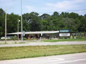
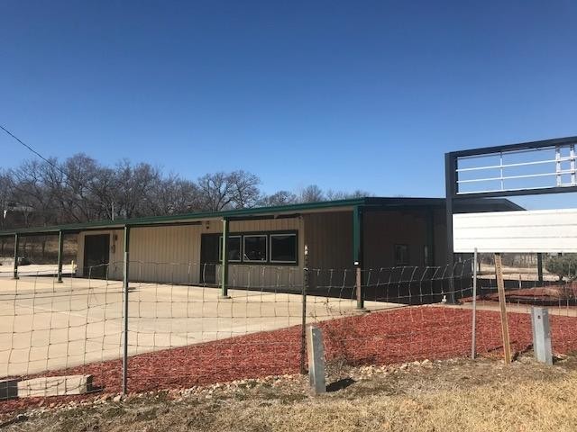
Property Record
100 W Gilman Rd, Lansing, KS 66043
NEARBY LISTINGS FOR SALE OR LEASE
Property Detail
100 W Gilman Rd
Kansas City, MO-KS
Lchs Hayslett Plat
107-25-0-00-00-015.00-0
Leavenworth
Horticulturegrowinghousesagricultural
Kansas
AE
3.22 AC
20103C0232G
Leavenworth County
4,080 SF
Kansas City
DEMOGRAPHICS near 100 W Gilman Rd
1 Mile
3 Mile
5 Mile
2024 Total Population
3,550
12,744
30,807
2029 Population
3,626
13,025
31,471
Pop Growth 2024-2029
+ 2.14%
+ 2.20%
+ 2.16%
Average Age
40
41
41
2024 Total Households
1,208
3,958
10,443
HH Growth 2024-2029
+ 2.32%
+ 2.25%
+ 2.28%
Median Household Inc
$131,525
$101,418
$92,328
Avg Household Size
2.90
2.70
2.60
2024 Avg HH Vehicles
3.00
2.00
2.00
Median Home Value
$325,070
$262,248
$260,971
Median Year Built
1989
1985
1986
Nearby Places
- Restaurants
- Banks
- Shops
- Fitness
- Groceries
PUBLIC TRANSPORTATION
AIRPORT
Kansas City International
DRIVE
WALK
Distance
Kansas City International
39 min
29.1 mi
Freight Ports
Tulsa Port Of Catoosa
DRIVE
WALK
Distance
Tulsa Port Of Catoosa
283 min
252.3 mi
SALE & LEASE HISTORY
LISTING DATE
SALE/LEASE

Sep 12, 2017
For Sale
Sep 12, 2017
For Sale
Nearby Properties
Address
Land Use
TOTAL SIZE
Lot Size
Zoning
Address
Land Use
TOTAL SIZE
Lot Size
Zoning
2,949 SF
398.40 AC
Address
Land Use
TOTAL SIZE
Lot Size
Zoning
238,164 SF
153.40 AC
Address
Land Use
TOTAL SIZE
Lot Size
Zoning
141,398 SF
24.21 AC
Address
Land Use
TOTAL SIZE
Lot Size
Zoning
200,862 SF
39.51 AC
Address
Land Use
TOTAL SIZE
Lot Size
Zoning
89,647 SF
24.76 AC
Address
Land Use
TOTAL SIZE
Lot Size
Zoning
48,527 SF
19.79 AC
Address
Land Use
TOTAL SIZE
Lot Size
Zoning
32,463 SF
7.60 AC
Address
Land Use
TOTAL SIZE
Lot Size
Zoning
26,000 SF
109.21 AC
WYAG
Address
Land Use
TOTAL SIZE
Lot Size
Zoning
55,961 SF
22.45 AC
Address
Land Use
TOTAL SIZE
Lot Size
Zoning
25,661 SF
3.47 AC
Address
Land Use
TOTAL SIZE
Lot Size
Zoning
346.96 AC
Address
Land Use
TOTAL SIZE
Lot Size
Zoning
20,573 SF
4.60 AC
Address
Land Use
TOTAL SIZE
Lot Size
Zoning
718,000 SF
30.37 AC
Address
Land Use
TOTAL SIZE
Lot Size
Zoning
94,112 SF
11.88 AC
Address
Land Use
TOTAL SIZE
Lot Size
Zoning
220.40 AC
Address
Land Use
TOTAL SIZE
Lot Size
Zoning
572 SF
128 AC
Address
Land Use
TOTAL SIZE
Lot Size
Zoning
12,000 SF
1.24 AC
Address
Land Use
TOTAL SIZE
Lot Size
Zoning
46,974 SF
5.61 AC
Address
Land Use
TOTAL SIZE
Lot Size
Zoning
183.61 AC
Address
Land Use
TOTAL SIZE
Lot Size
Zoning
26,053 SF
5.24 AC
Address
Land Use
TOTAL SIZE
Lot Size
Zoning
15,444 SF
4.91 AC
Address
Land Use
TOTAL SIZE
Lot Size
Zoning
86,692 SF
9.38 AC
Address
Land Use
TOTAL SIZE
Lot Size
Zoning
47.61 AC
WYAG
Address
Land Use
TOTAL SIZE
Lot Size
Zoning
55,384 SF
7.47 AC
Address
Land Use
TOTAL SIZE
Lot Size
Zoning
20,948 SF
9.70 AC
Address
Land Use
TOTAL SIZE
Lot Size
Zoning
38,632 SF
5.60 AC
Address
Land Use
TOTAL SIZE
Lot Size
Zoning
24,254 SF
2.36 AC
Address
Land Use
TOTAL SIZE
Lot Size
Zoning
4,966 SF
1.82 AC
Address
Land Use
TOTAL SIZE
Lot Size
Zoning
45,520 SF
6.35 AC
Address
Land Use
TOTAL SIZE
Lot Size
Zoning
31,671 SF
2.85 AC
The World's #1 Commercial Real Estate Marketplace
Connect with us
© 2025 CoStar Group
The information above has been obtained from sources believed reliable. While we do not doubt its accuracy we have not verified it and make no guarantee, warranty or representation about it. It is your responsibility to independently confirm its accuracy and completeness. Any projections, opinions, assumptions, or estimates used are for example only and do not represent the current or future performance of the property. The value of this transaction to you depends on tax and other factors which should be evaluated by your tax, financial, and legal advisors. You and your advisors should conduct a careful, independent investigation of the property to determine to your satisfaction the suitability of the property for your needs.