Property Record
100 W Lasalle Dr, Bismarck, ND 58503
NEARBY LISTINGS FOR SALE OR LEASE
Property Detail
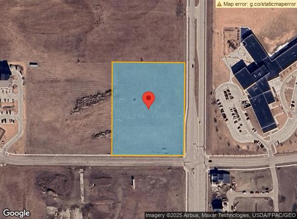
100 W Lasalle Dr
Bismarck, ND
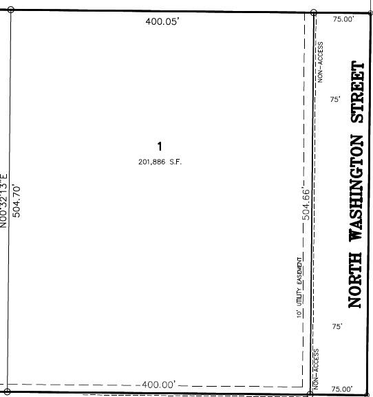
Brei Estates First Add Replat
2111-001-001
BREI ESTATES FIRST ADD REPLAT LOT 1
Commercialacreage
Burleigh
X
North Dakota
38015C0785E
1
2023
4.64 AC
2023
North Bismarck
011104
Other Market Areas
DEMOGRAPHICS near 100 W Lasalle Dr
1 Mile
3 Mile
5 Mile
2024 Total Population
7,079
35,749
82,020
2029 Population
7,369
36,882
84,729
Pop Growth 2024-2029
+ 4.10%
+ 3.17%
+ 3.30%
Average Age
38
41
41
2024 Total Households
2,513
15,028
34,960
HH Growth 2024-2029
+ 4.18%
+ 3.15%
+ 3.33%
Median Household Inc
$113,290
$74,344
$66,761
Avg Household Size
2.70
2.30
2.20
2024 Avg HH Vehicles
2.00
2.00
2.00
Median Home Value
$374,482
$309,646
$274,299
Median Year Built
2010
1998
1985
Nearby Places
- Restaurants
- Banks
- Shops
- Fitness
- Groceries
PUBLIC TRANSPORTATION
AIRPORT
Bismarck Municipal
DRIVE
WALK
Distance
Bismarck Municipal
24 min
9.4 mi
Freight Ports
Port Milwaukee
DRIVE
WALK
Distance
Port Milwaukee
826 min
766.5 mi
Nearby Properties
Address
Land Use
TOTAL SIZE
Lot Size
Zoning
Address
Land Use
TOTAL SIZE
Lot Size
Zoning
13.47 AC
PUD
Address
Land Use
TOTAL SIZE
Lot Size
Zoning
15.01 AC
RT
Address
Land Use
TOTAL SIZE
Lot Size
Zoning
28.06 AC
CG
Address
Land Use
TOTAL SIZE
Lot Size
Zoning
7.67 AC
CG
Address
Land Use
TOTAL SIZE
Lot Size
Zoning
76,233 SF
14.71 AC
RM20
Address
Land Use
TOTAL SIZE
Lot Size
Zoning
18.70 AC
RM15
Address
Land Use
TOTAL SIZE
Lot Size
Zoning
70,182 SF
3.83 AC
PUD
Address
Land Use
TOTAL SIZE
Lot Size
Zoning
27.48 AC
CG
Address
Land Use
TOTAL SIZE
Lot Size
Zoning
31,202 SF
9.05 AC
RM30
Address
Land Use
TOTAL SIZE
Lot Size
Zoning
38,467 SF
13.88 AC
CG
Address
Land Use
TOTAL SIZE
Lot Size
Zoning
20.87 AC
CG
Address
Land Use
TOTAL SIZE
Lot Size
Zoning
65,001 SF
9.88 AC
RT
Address
Land Use
TOTAL SIZE
Lot Size
Zoning
16.12 AC
CG
Address
Land Use
TOTAL SIZE
Lot Size
Zoning
38,275 SF
10.53 AC
RM30
Address
Land Use
TOTAL SIZE
Lot Size
Zoning
39,771 SF
9.65 AC
CG
Address
Land Use
TOTAL SIZE
Lot Size
Zoning
27,639 SF
4.28 AC
RT
Address
Land Use
TOTAL SIZE
Lot Size
Zoning
7.83 AC
RM20
Address
Land Use
TOTAL SIZE
Lot Size
Zoning
77,694 SF
8.66 AC
RT
Address
Land Use
TOTAL SIZE
Lot Size
Zoning
52,718 SF
2.67 AC
RM15
Address
Land Use
TOTAL SIZE
Lot Size
Zoning
13.98 AC
CG
Address
Land Use
TOTAL SIZE
Lot Size
Zoning
74,564 SF
6.67 AC
RT
Address
Land Use
TOTAL SIZE
Lot Size
Zoning
8,685 SF
12.51 AC
CG
Address
Land Use
TOTAL SIZE
Lot Size
Zoning
57,580 SF
8.85 AC
CG
Address
Land Use
TOTAL SIZE
Lot Size
Zoning
40,647 SF
2.67 AC
PUD
Address
Land Use
TOTAL SIZE
Lot Size
Zoning
25,831 SF
17.10 AC
CG
Address
Land Use
TOTAL SIZE
Lot Size
Zoning
3.90 AC
RM30
Address
Land Use
TOTAL SIZE
Lot Size
Zoning
74,250 SF
5.63 AC
PUD
Address
Land Use
TOTAL SIZE
Lot Size
Zoning
15,656 SF
8.98 AC
RM30
Address
Land Use
TOTAL SIZE
Lot Size
Zoning
25.59 AC
CG
Address
Land Use
TOTAL SIZE
Lot Size
Zoning
43,708 SF
4.27 AC
RT
The World's #1 Commercial Real Estate Marketplace
Connect with us
© 2025 CoStar Group
The information above has been obtained from sources believed reliable. While we do not doubt its accuracy we have not verified it and make no guarantee, warranty or representation about it. It is your responsibility to independently confirm its accuracy and completeness. Any projections, opinions, assumptions, or estimates used are for example only and do not represent the current or future performance of the property. The value of this transaction to you depends on tax and other factors which should be evaluated by your tax, financial, and legal advisors. You and your advisors should conduct a careful, independent investigation of the property to determine to your satisfaction the suitability of the property for your needs.