Property Record
1000 Cassandra Ln, La Grange, KY 40031

NEARBY LISTINGS FOR SALE OR LEASE
-
-
View all La Grange listings for sale on LoopNet.com
Property Detail
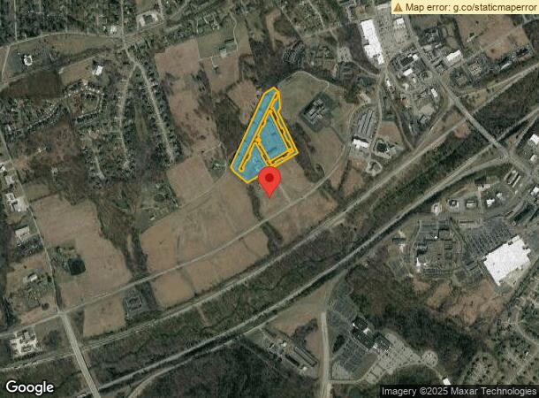
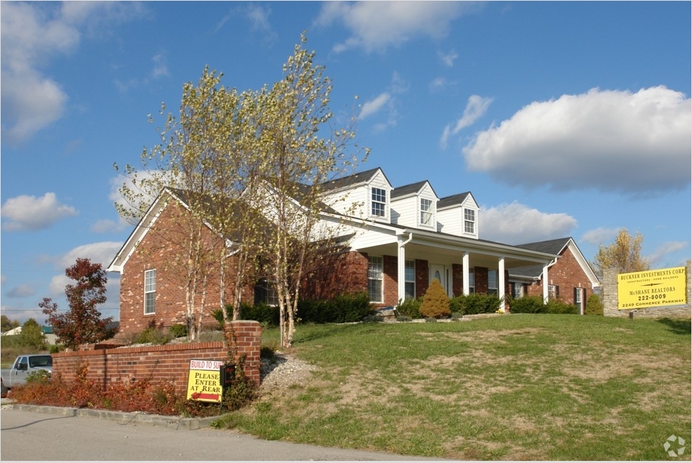
1000 Cassandra Ln
Louisville-Jefferson County, KY-IN
9 APT BLDS , 80 GAR, CLUBHOUSE &14.006AC
47-00-00-29A
Oldham
Apartment
Kentucky
X
29a
21185C0120D
33.71 AC
2023
Oldham County
2023
Louisville
030301
DEMOGRAPHICS near 1000 Cassandra Ln
1 Mile
3 Mile
5 Mile
2024 Total Population
4,037
20,032
35,508
2029 Population
4,287
21,132
37,375
Pop Growth 2024-2029
+ 6.19%
+ 5.49%
+ 5.26%
Average Age
38
39
40
2024 Total Households
1,499
6,624
11,174
HH Growth 2024-2029
+ 6.40%
+ 6.02%
+ 5.85%
Median Household Inc
$65,460
$82,761
$94,269
Avg Household Size
2.60
2.70
2.80
2024 Avg HH Vehicles
2.00
2.00
2.00
Median Home Value
$253,712
$272,635
$309,715
Median Year Built
1995
1993
1993
Nearby Places
- Restaurants
- Banks
- Shops
- Fitness
- Groceries
PUBLIC TRANSPORTATION
AIRPORT
Louisville Muhammad Ali International
DRIVE
WALK
Distance
Louisville Muhammad Ali International
44 min
31.3 mi
Freight Ports
Port of Toledo
DRIVE
WALK
Distance
Port of Toledo
326 min
281.6 mi
Nearby Properties
Address
Land Use
TOTAL SIZE
Lot Size
Zoning
Address
Land Use
TOTAL SIZE
Lot Size
Zoning
Address
Land Use
TOTAL SIZE
Lot Size
Zoning
85.51 AC
Address
Land Use
TOTAL SIZE
Lot Size
Zoning
11.84 AC
Address
Land Use
TOTAL SIZE
Lot Size
Zoning
67.01 AC
Address
Land Use
TOTAL SIZE
Lot Size
Zoning
Address
Land Use
TOTAL SIZE
Lot Size
Zoning
295.27 AC
Address
Land Use
TOTAL SIZE
Lot Size
Zoning
151.49 AC
Address
Land Use
TOTAL SIZE
Lot Size
Zoning
17.68 AC
Address
Land Use
TOTAL SIZE
Lot Size
Zoning
25.49 AC
Address
Land Use
TOTAL SIZE
Lot Size
Zoning
11.95 AC
Address
Land Use
TOTAL SIZE
Lot Size
Zoning
7.07 AC
Address
Land Use
TOTAL SIZE
Lot Size
Zoning
Address
Land Use
TOTAL SIZE
Lot Size
Zoning
3.29 AC
Address
Land Use
TOTAL SIZE
Lot Size
Zoning
1.45 AC
Address
Land Use
TOTAL SIZE
Lot Size
Zoning
2.08 AC
Address
Land Use
TOTAL SIZE
Lot Size
Zoning
5.19 AC
Address
Land Use
TOTAL SIZE
Lot Size
Zoning
3.36 AC
Address
Land Use
TOTAL SIZE
Lot Size
Zoning
Address
Land Use
TOTAL SIZE
Lot Size
Zoning
9.58 AC
Address
Land Use
TOTAL SIZE
Lot Size
Zoning
0.81 AC
Address
Land Use
TOTAL SIZE
Lot Size
Zoning
75.21 AC
Address
Land Use
TOTAL SIZE
Lot Size
Zoning
60.37 AC
Address
Land Use
TOTAL SIZE
Lot Size
Zoning
3.34 AC
Address
Land Use
TOTAL SIZE
Lot Size
Zoning
0.28 AC
Address
Land Use
TOTAL SIZE
Lot Size
Zoning
48.82 AC
Address
Land Use
TOTAL SIZE
Lot Size
Zoning
46,572 SF
3 AC
Address
Land Use
TOTAL SIZE
Lot Size
Zoning
6.45 AC
Address
Land Use
TOTAL SIZE
Lot Size
Zoning
2.44 AC
The World's #1 Commercial Real Estate Marketplace
Connect with us
© 2025 CoStar Group
The information above has been obtained from sources believed reliable. While we do not doubt its accuracy we have not verified it and make no guarantee, warranty or representation about it. It is your responsibility to independently confirm its accuracy and completeness. Any projections, opinions, assumptions, or estimates used are for example only and do not represent the current or future performance of the property. The value of this transaction to you depends on tax and other factors which should be evaluated by your tax, financial, and legal advisors. You and your advisors should conduct a careful, independent investigation of the property to determine to your satisfaction the suitability of the property for your needs.