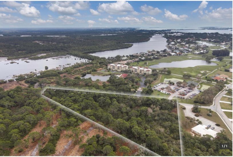
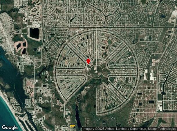
Property Record
10020 Links Ln, Rotonda West, FL 33947
NEARBY LISTINGS FOR SALE OR LEASE
Property Detail
10020 Links Ln
Punta Gorda, FL
Cape Haze Windward
412035302002
CAPE HAZE WINDWARD TRACT B 3.73 AC. M/L 1690/2036 2591/1896 2869/447 3392/63
Commercialacreage
Charlotte
AE
Florida
12015C0356G
1690
2023
3.73 AC
2023
Charlotte County
030506
Southwest Florida
DEMOGRAPHICS near 10020 Links Ln
1 Mile
3 Mile
5 Mile
2024 Total Population
1,168
15,162
34,392
2029 Population
1,482
18,660
41,936
Pop Growth 2024-2029
+ 26.88%
+ 23.07%
+ 21.94%
Average Age
63
61
58
2024 Total Households
629
7,642
16,743
HH Growth 2024-2029
+ 26.87%
+ 23.17%
+ 22.08%
Median Household Inc
$63,256
$59,381
$60,825
Avg Household Size
1.90
2.00
2.00
2024 Avg HH Vehicles
2.00
2.00
2.00
Median Home Value
$351,041
$298,559
$285,027
Median Year Built
1996
1995
1995
Nearby Places
- Restaurants
- Banks
- Shops
- Fitness
- Groceries
PUBLIC TRANSPORTATION
AIRPORT
Punta Gorda
DRIVE
WALK
Distance
Punta Gorda
47 min
26.6 mi
Freight Ports
Port Manatee
DRIVE
WALK
Distance
Port Manatee
88 min
62.2 mi
SALE & LEASE HISTORY
LISTING DATE
SALE/LEASE

Aug 14, 2024
For Sale
Nearby Properties
Address
Land Use
TOTAL SIZE
Lot Size
Zoning
Address
Land Use
TOTAL SIZE
Lot Size
Zoning
105,990 SF
17.30 AC
RMF15
Address
Land Use
TOTAL SIZE
Lot Size
Zoning
28,490 SF
172 AC
PKR
Address
Land Use
TOTAL SIZE
Lot Size
Zoning
55,760 SF
3.18 AC
CG
Address
Land Use
TOTAL SIZE
Lot Size
Zoning
107,736 SF
35.90 AC
RMF5
Address
Land Use
TOTAL SIZE
Lot Size
Zoning
25,777 SF
12.18 AC
PD
Address
Land Use
TOTAL SIZE
Lot Size
Zoning
106,737 SF
20.80 AC
RMF5
Address
Land Use
TOTAL SIZE
Lot Size
Zoning
14.21 AC
II
Address
Land Use
TOTAL SIZE
Lot Size
Zoning
11,718 SF
0.15 AC
WDR4*
Address
Land Use
TOTAL SIZE
Lot Size
Zoning
15.79 AC
CT
Address
Land Use
TOTAL SIZE
Lot Size
Zoning
24,708 SF
14.89 AC
CT
Address
Land Use
TOTAL SIZE
Lot Size
Zoning
25,685 SF
126.18 AC
RMF-T
Address
Land Use
TOTAL SIZE
Lot Size
Zoning
51,683 SF
7.16 AC
CG
Address
Land Use
TOTAL SIZE
Lot Size
Zoning
33,047 SF
10.17 AC
PKR
Address
Land Use
TOTAL SIZE
Lot Size
Zoning
7,558 SF
0.40 AC
BBI
Address
Land Use
TOTAL SIZE
Lot Size
Zoning
5.36 AC
II
Address
Land Use
TOTAL SIZE
Lot Size
Zoning
38.60 AC
PD
Address
Land Use
TOTAL SIZE
Lot Size
Zoning
2,387.99 AC
ES
Address
Land Use
TOTAL SIZE
Lot Size
Zoning
25,130 SF
21.98 AC
RE1
Address
Land Use
TOTAL SIZE
Lot Size
Zoning
27,501 SF
3.82 AC
CG
Address
Land Use
TOTAL SIZE
Lot Size
Zoning
25,827 SF
9.34 AC
RMF15
Address
Land Use
TOTAL SIZE
Lot Size
Zoning
15,190 SF
154.40 AC
RSF5
Address
Land Use
TOTAL SIZE
Lot Size
Zoning
50,080 SF
5.09 AC
CG
Address
Land Use
TOTAL SIZE
Lot Size
Zoning
8.47 AC
RMF10
Address
Land Use
TOTAL SIZE
Lot Size
Zoning
26,248 SF
6.32 AC
PD
Address
Land Use
TOTAL SIZE
Lot Size
Zoning
16,017 SF
169.47 AC
RSF5
Address
Land Use
TOTAL SIZE
Lot Size
Zoning
58,000 SF
7.85 AC
CG
Address
Land Use
TOTAL SIZE
Lot Size
Zoning
6,852 SF
161.47 AC
RSF5
Address
Land Use
TOTAL SIZE
Lot Size
Zoning
13,682 SF
4.46 AC
CG
Address
Land Use
TOTAL SIZE
Lot Size
Zoning
23,927 SF
0.17 AC
CG
Address
Land Use
TOTAL SIZE
Lot Size
Zoning
6,959 SF
1.13 AC
CG
The World's #1 Commercial Real Estate Marketplace
Connect with us
© 2025 CoStar Group
The information above has been obtained from sources believed reliable. While we do not doubt its accuracy we have not verified it and make no guarantee, warranty or representation about it. It is your responsibility to independently confirm its accuracy and completeness. Any projections, opinions, assumptions, or estimates used are for example only and do not represent the current or future performance of the property. The value of this transaction to you depends on tax and other factors which should be evaluated by your tax, financial, and legal advisors. You and your advisors should conduct a careful, independent investigation of the property to determine to your satisfaction the suitability of the property for your needs.