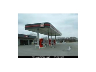
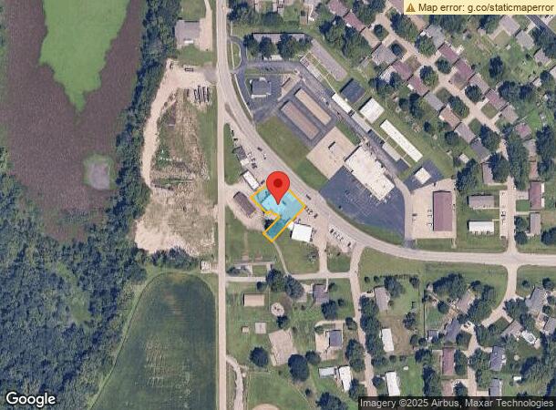
Property Record
10021 Nw Us Highway 24, Silver Lake, KS 66539
NEARBY LISTINGS FOR SALE OR LEASE
-
-
View all Silver Lake listings for sale on LoopNet.com
Property Detail
10021 Nw Us Highway 24
Topeka, KS
Hamilton Heights Sub Rpl
085-16-0-10-13-001-040
HAMILTON HEIGHTS SUB RPL, S16, T11, R14, BLOCK A, LOT 2, PT LOT 2 BLK A REPLAT OF HAMILTON HEIGHTS SUB BEG 11.7 NW OF COM FRONT COR LOTS 2 & 4 TH SW 164.14 NW 37.10 NE 78.75 NW 16.42 SW 7.17 SECTION 16 TOWNSHIP 11 RANGE 14
Storebuilding
Shawnee
AE
Kansas
20177C0176E
2
2023
0.37 AC
2023
Topeka
003500
Kansas City
2,356 SF
DEMOGRAPHICS near 10021 Nw Us Highway 24
1 Mile
3 Mile
5 Mile
2024 Total Population
1,255
2,086
3,675
2029 Population
1,217
2,030
3,588
Pop Growth 2024-2029
(3.03%)
(2.68%)
(2.37%)
Average Age
41
42
42
2024 Total Households
514
820
1,419
HH Growth 2024-2029
(3.11%)
(2.80%)
(2.54%)
Median Household Inc
$49,104
$55,000
$67,777
Avg Household Size
2.40
2.50
2.60
2024 Avg HH Vehicles
2.00
2.00
2.00
Median Home Value
$161,276
$181,545
$203,593
Median Year Built
1970
1972
1976
Nearby Places
- Restaurants
- Banks
- Shops
- Fitness
- Groceries
Nearby Properties
Address
Land Use
TOTAL SIZE
Lot Size
Zoning
Address
Land Use
TOTAL SIZE
Lot Size
Zoning
98,572 SF
18.65 AC
RA1
Address
Land Use
TOTAL SIZE
Lot Size
Zoning
42,705 SF
8.01 AC
RA1
Address
Land Use
TOTAL SIZE
Lot Size
Zoning
11,651 SF
1.14 AC
RA1
Address
Land Use
TOTAL SIZE
Lot Size
Zoning
7,488 SF
12.60 AC
RA1
Address
Land Use
TOTAL SIZE
Lot Size
Zoning
4,360 SF
13.24 AC
RA1
Address
Land Use
TOTAL SIZE
Lot Size
Zoning
5,436 SF
0.61 AC
RA1
Address
Land Use
TOTAL SIZE
Lot Size
Zoning
8,265 SF
0.32 AC
RA1
Address
Land Use
TOTAL SIZE
Lot Size
Zoning
7,285 SF
0.48 AC
RA1
Address
Land Use
TOTAL SIZE
Lot Size
Zoning
5,400 SF
3.92 AC
RA1
Address
Land Use
TOTAL SIZE
Lot Size
Zoning
9.27 AC
RA1
Address
Land Use
TOTAL SIZE
Lot Size
Zoning
4,062 SF
0.33 AC
RA1
Address
Land Use
TOTAL SIZE
Lot Size
Zoning
2.51 AC
RA1
Address
Land Use
TOTAL SIZE
Lot Size
Zoning
10,170 SF
7.04 AC
C4
Address
Land Use
TOTAL SIZE
Lot Size
Zoning
17,078 SF
2.50 AC
M1
Address
Land Use
TOTAL SIZE
Lot Size
Zoning
75.08 AC
RA1
Address
Land Use
TOTAL SIZE
Lot Size
Zoning
3,456 SF
0.19 AC
C4
Address
Land Use
TOTAL SIZE
Lot Size
Zoning
17,313 SF
1.12 AC
I1
Address
Land Use
TOTAL SIZE
Lot Size
Zoning
7,592 SF
0.13 AC
C4
Address
Land Use
TOTAL SIZE
Lot Size
Zoning
24,576 SF
4.39 AC
I1,RA1
Address
Land Use
TOTAL SIZE
Lot Size
Zoning
3,752 SF
9.83 AC
RA1
Address
Land Use
TOTAL SIZE
Lot Size
Zoning
37.47 AC
RA1
Address
Land Use
TOTAL SIZE
Lot Size
Zoning
5,296 SF
0.39 AC
C4,RA1
Address
Land Use
TOTAL SIZE
Lot Size
Zoning
1,472 SF
1.87 AC
RA1
Address
Land Use
TOTAL SIZE
Lot Size
Zoning
4,560 SF
0.20 AC
RA1
Address
Land Use
TOTAL SIZE
Lot Size
Zoning
15,030 SF
1.06 AC
C2,RA1
Address
Land Use
TOTAL SIZE
Lot Size
Zoning
4,920 SF
0.45 AC
C4
Address
Land Use
TOTAL SIZE
Lot Size
Zoning
6,072 SF
0.62 AC
RA1
Address
Land Use
TOTAL SIZE
Lot Size
Zoning
13.75 AC
RA1
Address
Land Use
TOTAL SIZE
Lot Size
Zoning
5,076 SF
20.07 AC
RA1
The World's #1 Commercial Real Estate Marketplace
Connect with us
© 2025 CoStar Group
The information above has been obtained from sources believed reliable. While we do not doubt its accuracy we have not verified it and make no guarantee, warranty or representation about it. It is your responsibility to independently confirm its accuracy and completeness. Any projections, opinions, assumptions, or estimates used are for example only and do not represent the current or future performance of the property. The value of this transaction to you depends on tax and other factors which should be evaluated by your tax, financial, and legal advisors. You and your advisors should conduct a careful, independent investigation of the property to determine to your satisfaction the suitability of the property for your needs.