Property Record
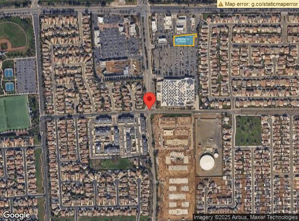
10065 Bruceville Rd, Elk Grove, CA 95757


This Property Is For Sale
NEARBY LISTINGS FOR SALE OR LEASE
Property Detail
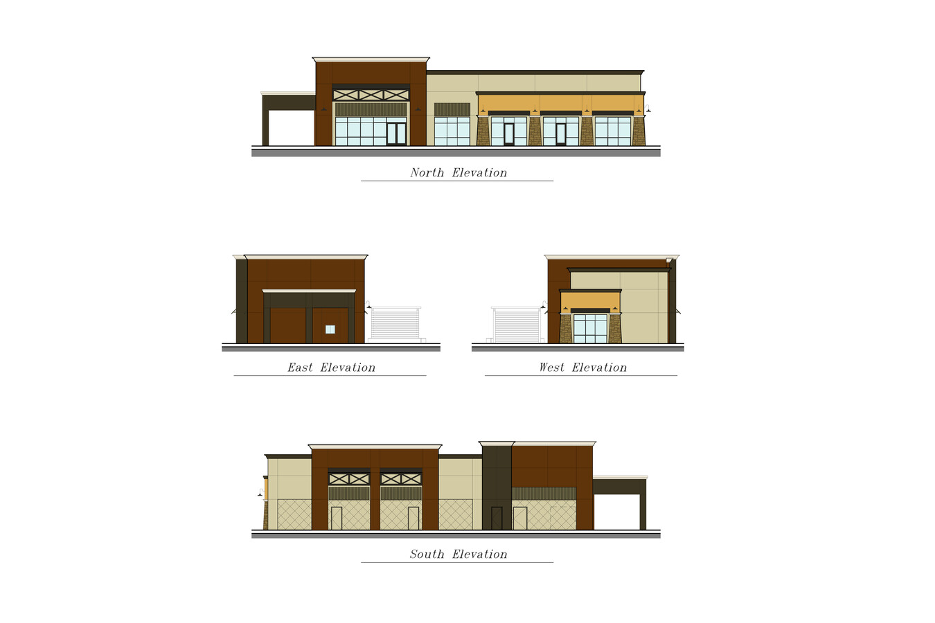
10065 Bruceville Rd
Sacramento--Roseville--Arden-Arcade, CA
Vineyard At Madeira Phase 3
132-2530-005
PARCEL MAP OF VINEYARD AT MADEIRA PHASE 3, LOT 5, UNIT:: 0, BLOCK:: 0, BLDG:: 0
Commercialacreage
Sacramento
X
California
06067C0318H
5
2023
0.73 AC
2024
Elk Grove
009652
Sacramento
DEMOGRAPHICS near 10065 Bruceville Rd
1 Mile
3 Mile
5 Mile
2024 Total Population
18,967
105,619
212,828
2029 Population
19,428
106,779
214,513
Pop Growth 2024-2029
+ 2.43%
+ 1.10%
+ 0.79%
Average Age
39
39
38
2024 Total Households
5,659
33,486
65,419
HH Growth 2024-2029
+ 2.56%
+ 1.04%
+ 0.76%
Median Household Inc
$125,750
$106,394
$104,801
Avg Household Size
3.30
3.10
3.20
2024 Avg HH Vehicles
2.00
2.00
2.00
Median Home Value
$662,472
$538,201
$520,884
Median Year Built
2009
2000
1998
Nearby Places
- Restaurants
- Banks
- Shops
- Fitness
- Groceries
PUBLIC TRANSPORTATION
AIRPORT
Sacramento International
DRIVE
WALK
Distance
Sacramento International
39 min
28.5 mi
Freight Ports
Port of Stockton
DRIVE
WALK
Distance
Port of Stockton
43 min
35.6 mi
Nearby Properties
Address
Land Use
TOTAL SIZE
Lot Size
Zoning
Address
Land Use
TOTAL SIZE
Lot Size
Zoning
468,870 SF
26.55 AC
RD-20
Address
Land Use
TOTAL SIZE
Lot Size
Zoning
265,222 SF
14.42 AC
RD-20
Address
Land Use
TOTAL SIZE
Lot Size
Zoning
268,881 SF
12.25 AC
RD-20
Address
Land Use
TOTAL SIZE
Lot Size
Zoning
7.65 AC
RD-20
Address
Land Use
TOTAL SIZE
Lot Size
Zoning
4.98 AC
RD-20
Address
Land Use
TOTAL SIZE
Lot Size
Zoning
102,085 SF
10.26 AC
BP
Address
Land Use
TOTAL SIZE
Lot Size
Zoning
147,920 SF
18.20 AC
SC
Address
Land Use
TOTAL SIZE
Lot Size
Zoning
152,217 SF
17.42 AC
SC
Address
Land Use
TOTAL SIZE
Lot Size
Zoning
64,579 SF
5.41 AC
LRSPA
Address
Land Use
TOTAL SIZE
Lot Size
Zoning
192,518 SF
8.97 AC
RD-20
Address
Land Use
TOTAL SIZE
Lot Size
Zoning
105,511 SF
6.67 AC
BP
Address
Land Use
TOTAL SIZE
Lot Size
Zoning
105,511 SF
4.79 AC
BP
Address
Land Use
TOTAL SIZE
Lot Size
Zoning
242,577 SF
0.10 AC
RD-20
Address
Land Use
TOTAL SIZE
Lot Size
Zoning
111,489 SF
4.96 AC
MP
Address
Land Use
TOTAL SIZE
Lot Size
Zoning
195,101 SF
12.21 AC
BP
Address
Land Use
TOTAL SIZE
Lot Size
Zoning
76,090 SF
3.32 AC
RD-25
Address
Land Use
TOTAL SIZE
Lot Size
Zoning
108,843 SF
4.14 AC
RD-30
Address
Land Use
TOTAL SIZE
Lot Size
Zoning
185,300 SF
11.63 AC
RD-20
Address
Land Use
TOTAL SIZE
Lot Size
Zoning
3.88 AC
RD-20
Address
Land Use
TOTAL SIZE
Lot Size
Zoning
221,954 SF
7.71 AC
RD-15
Address
Land Use
TOTAL SIZE
Lot Size
Zoning
4.88 AC
RD-25
Address
Land Use
TOTAL SIZE
Lot Size
Zoning
91,226 SF
10.81 AC
SC
Address
Land Use
TOTAL SIZE
Lot Size
Zoning
83,274 SF
9.14 AC
SC
Address
Land Use
TOTAL SIZE
Lot Size
Zoning
110,372 SF
2.68 AC
BP
Address
Land Use
TOTAL SIZE
Lot Size
Zoning
102,526 SF
4.06 AC
MP
Address
Land Use
TOTAL SIZE
Lot Size
Zoning
65,148 SF
5.77 AC
GC
Address
Land Use
TOTAL SIZE
Lot Size
Zoning
100 SF
50.85 AC
LRSPA
Address
Land Use
TOTAL SIZE
Lot Size
Zoning
42,890 SF
4.38 AC
MP
Address
Land Use
TOTAL SIZE
Lot Size
Zoning
88,408 SF
9.41 AC
SC
Address
Land Use
TOTAL SIZE
Lot Size
Zoning
66,793 SF
2.48 AC
SC
The World's #1 Commercial Real Estate Marketplace
Connect with us
© 2025 CoStar Group
The information above has been obtained from sources believed reliable. While we do not doubt its accuracy we have not verified it and make no guarantee, warranty or representation about it. It is your responsibility to independently confirm its accuracy and completeness. Any projections, opinions, assumptions, or estimates used are for example only and do not represent the current or future performance of the property. The value of this transaction to you depends on tax and other factors which should be evaluated by your tax, financial, and legal advisors. You and your advisors should conduct a careful, independent investigation of the property to determine to your satisfaction the suitability of the property for your needs.