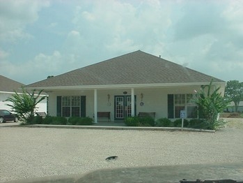
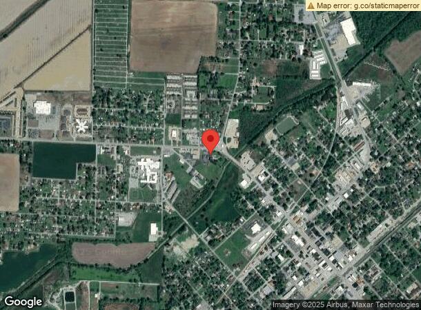
Property Record
1007 W Main St, Walnut Ridge, AR 72476
NEARBY LISTINGS FOR SALE OR LEASE
-
-
View all Walnut Ridge listings for sale on LoopNet.com
Property Detail
1007 W Main St
Officebuilding
Walnut Ridge Unpl
AE
PT NW NE
05075C0280D
Lawrence
2023
Arkansas
2024
1.79 AC
470502
Other Market Areas
2,806 SF
850-02172-002-C
DEMOGRAPHICS near 1007 W Main St
1 Mile
3 Mile
5 Mile
2024 Total Population
4,221
7,878
8,593
2029 Population
4,267
7,945
8,650
Pop Growth 2024-2029
+ 1.09%
+ 0.85%
+ 0.66%
Average Age
42
41
41
2024 Total Households
1,706
3,201
3,451
HH Growth 2024-2029
+ 1.17%
+ 0.87%
+ 0.72%
Median Household Inc
$38,581
$36,090
$35,885
Avg Household Size
2.30
2.30
2.30
2024 Avg HH Vehicles
2.00
2.00
2.00
Median Home Value
$92,581
$79,637
$78,773
Median Year Built
1975
1975
1975
Nearby Places
- Restaurants
- Banks
- Shops
- Fitness
- Groceries
PUBLIC TRANSPORTATION
COMMUTER RAIL
Walnut Ridge Amtrak Station (Texas Eagle - Amtrak)
DRIVE
WALK
Distance
Walnut Ridge Amtrak Station (Texas Eagle - Amtrak)
1 min
13 min
0.7 mi
Freight Ports
Tulsa Port of Inola
DRIVE
WALK
Distance
Tulsa Port of Inola
379 min
310.6 mi
Nearby Properties
Address
Land Use
TOTAL SIZE
Lot Size
Zoning
Address
Land Use
TOTAL SIZE
Lot Size
Zoning
28,632 SF
20.40 AC
Address
Land Use
TOTAL SIZE
Lot Size
Zoning
26,555 SF
8 AC
Address
Land Use
TOTAL SIZE
Lot Size
Zoning
42,042 SF
Address
Land Use
TOTAL SIZE
Lot Size
Zoning
57,403 SF
12.95 AC
Address
Land Use
TOTAL SIZE
Lot Size
Zoning
121,645 SF
0.88 AC
Address
Land Use
TOTAL SIZE
Lot Size
Zoning
2,821 SF
2.66 AC
Address
Land Use
TOTAL SIZE
Lot Size
Zoning
5,312 SF
5 AC
Address
Land Use
TOTAL SIZE
Lot Size
Zoning
6,828 SF
Address
Land Use
TOTAL SIZE
Lot Size
Zoning
5,077 SF
Address
Land Use
TOTAL SIZE
Lot Size
Zoning
12,424 SF
5 AC
Address
Land Use
TOTAL SIZE
Lot Size
Zoning
25,718 SF
2.84 AC
Address
Land Use
TOTAL SIZE
Lot Size
Zoning
12,250 SF
5.71 AC
Address
Land Use
TOTAL SIZE
Lot Size
Zoning
2,109 SF
2.14 AC
Address
Land Use
TOTAL SIZE
Lot Size
Zoning
6,660 SF
1.58 AC
Address
Land Use
TOTAL SIZE
Lot Size
Zoning
9,348 SF
3.51 AC
Address
Land Use
TOTAL SIZE
Lot Size
Zoning
39,050 SF
Address
Land Use
TOTAL SIZE
Lot Size
Zoning
6,575 SF
Address
Land Use
TOTAL SIZE
Lot Size
Zoning
7,000 SF
3.50 AC
Address
Land Use
TOTAL SIZE
Lot Size
Zoning
3,004 SF
Address
Land Use
TOTAL SIZE
Lot Size
Zoning
11,868 SF
6.25 AC
Address
Land Use
TOTAL SIZE
Lot Size
Zoning
15,906 SF
3.05 AC
Address
Land Use
TOTAL SIZE
Lot Size
Zoning
4,968 SF
Address
Land Use
TOTAL SIZE
Lot Size
Zoning
8,400 SF
19.98 AC
Address
Land Use
TOTAL SIZE
Lot Size
Zoning
12,600 SF
3.59 AC
Address
Land Use
TOTAL SIZE
Lot Size
Zoning
4,172 SF
0.81 AC
Address
Land Use
TOTAL SIZE
Lot Size
Zoning
5,520 SF
Address
Land Use
TOTAL SIZE
Lot Size
Zoning
9,028 SF
3.88 AC
Address
Land Use
TOTAL SIZE
Lot Size
Zoning
Address
Land Use
TOTAL SIZE
Lot Size
Zoning
3,150 SF
Address
Land Use
TOTAL SIZE
Lot Size
Zoning
5,175 SF
The World's #1 Commercial Real Estate Marketplace
Connect with us
© 2025 CoStar Group
The information above has been obtained from sources believed reliable. While we do not doubt its accuracy we have not verified it and make no guarantee, warranty or representation about it. It is your responsibility to independently confirm its accuracy and completeness. Any projections, opinions, assumptions, or estimates used are for example only and do not represent the current or future performance of the property. The value of this transaction to you depends on tax and other factors which should be evaluated by your tax, financial, and legal advisors. You and your advisors should conduct a careful, independent investigation of the property to determine to your satisfaction the suitability of the property for your needs.