Property Record
1008 Sr, , NC

Property Detail
1008 Sr
02K18024
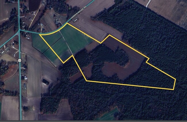
TRACT 1 ADAMS 33/317
Vacantlandnec
JOHNSTON
RAG
North Carolina
B and X Area of moderate flood hazard, usually the area between the limits of the 100-year and 500-year floods.
64.45 AC
2025
Johnston County
2025
Raleigh/Durham
0413002019
Raleigh-Cary, NC
NEARBY LISTINGS FOR SALE OR LEASE
-
-
View all listings for sale on LoopNet.com
DEMOGRAPHICS near 1008 Sr
1 mile
3 mile
5 mile
2025 Total Population
295
2,303
4,878
2030 Population
325
2,486
5,260
Pop Growth 2025-2030
+ 10.17%
+ 7.95%
+ 7.83%
Average Age
41
41
41
2025 Total Households
112
895
1,876
HH Growth 2025-2030
+ 9.82%
+ 7.82%
+ 7.84%
Median Household Inc
$77,500
$70,874
$68,791
Avg Household Size
2.50
2.50
2.50
2025 Avg HH Vehicles
3.00
2.00
2.00
Median Home Value
$157,142
$157,038
$151,794
Median Year Built
1991
1990
1989
Nearby Places
Map Layers
Map Styles
 Street
 Aerial
Transit
 Traffic
 Biking
Places
Listings with unknown addresses are not visible on the map
- Restaurants
- Banks
- Shops
- Fitness
- Groceries
SALE & LEASE HISTORY
LISTING DATE
SALE/LEASE

Sep 25, 2024
For Sale
Nearby Properties
Address
Land Use
TOTAL SIZE
Lot Size
Zoning
Address
Land Use
TOTAL SIZE
Lot Size
Zoning
12.36 AC
Address
Land Use
TOTAL SIZE
Lot Size
Zoning
4,416 SF
5.82 AC
Address
Land Use
TOTAL SIZE
Lot Size
Zoning
6.45 AC
Address
Land Use
TOTAL SIZE
Lot Size
Zoning
7.47 AC
Address
Land Use
TOTAL SIZE
Lot Size
Zoning
10,000 SF
2 AC
RAG
Address
Land Use
TOTAL SIZE
Lot Size
Zoning
7,200 SF
69.20 AC
COM
Address
Land Use
TOTAL SIZE
Lot Size
Zoning
Address
Land Use
TOTAL SIZE
Lot Size
Zoning
Address
Land Use
TOTAL SIZE
Lot Size
Zoning
Address
Land Use
TOTAL SIZE
Lot Size
Zoning
Address
Land Use
TOTAL SIZE
Lot Size
Zoning
1,800 SF
107.49 AC
RAG
Address
Land Use
TOTAL SIZE
Lot Size
Zoning
3.61 AC
Address
Land Use
TOTAL SIZE
Lot Size
Zoning
160.40 AC
RAG
Address
Land Use
TOTAL SIZE
Lot Size
Zoning
209.65 AC
RAG
Address
Land Use
TOTAL SIZE
Lot Size
Zoning
2.18 AC
Address
Land Use
TOTAL SIZE
Lot Size
Zoning
3,472 SF
8.72 AC
RAG
Address
Land Use
TOTAL SIZE
Lot Size
Zoning
Address
Land Use
TOTAL SIZE
Lot Size
Zoning
Address
Land Use
TOTAL SIZE
Lot Size
Zoning
112.77 AC
RAG
Address
Land Use
TOTAL SIZE
Lot Size
Zoning
110.85 AC
RAG
Address
Land Use
TOTAL SIZE
Lot Size
Zoning
143.93 AC
RAG
Address
Land Use
TOTAL SIZE
Lot Size
Zoning
Address
Land Use
TOTAL SIZE
Lot Size
Zoning
1,117 SF
106.25 AC
RAG
Address
Land Use
TOTAL SIZE
Lot Size
Zoning
153.92 AC
RAG
Address
Land Use
TOTAL SIZE
Lot Size
Zoning
3,000 SF
1.10 AC
RAG
Address
Land Use
TOTAL SIZE
Lot Size
Zoning
3.92 AC
Address
Land Use
TOTAL SIZE
Lot Size
Zoning
Address
Land Use
TOTAL SIZE
Lot Size
Zoning
5.65 AC
Address
Land Use
TOTAL SIZE
Lot Size
Zoning
4,500 SF
39.60 AC
RES
The World's #1 Commercial Real Estate Marketplace
Connect with us
© 2026 CoStar Group
The information above has been obtained from sources believed reliable. While we do not doubt its accuracy we have not verified it and make no guarantee, warranty or representation about it. It is your responsibility to independently confirm its accuracy and completeness. Any projections, opinions, assumptions, or estimates used are for example only and do not represent the current or future performance of the property. The value of this transaction to you depends on tax and other factors which should be evaluated by your tax, financial, and legal advisors. You and your advisors should conduct a careful, independent investigation of the property to determine to your satisfaction the suitability of the property for your needs.