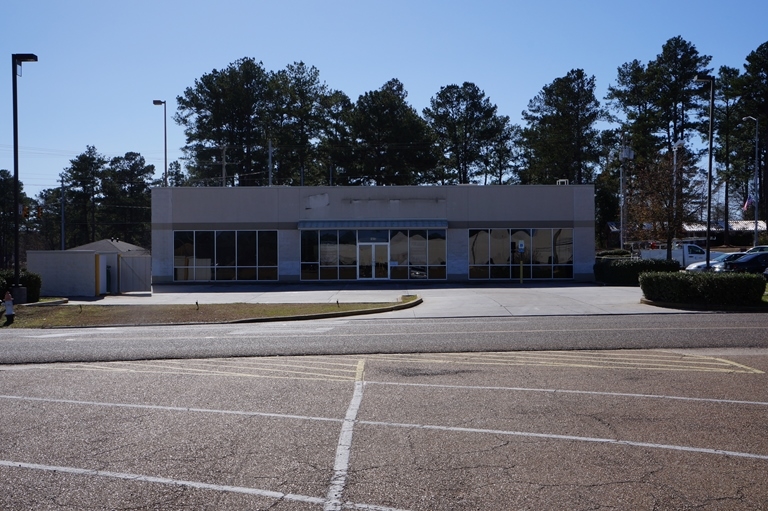
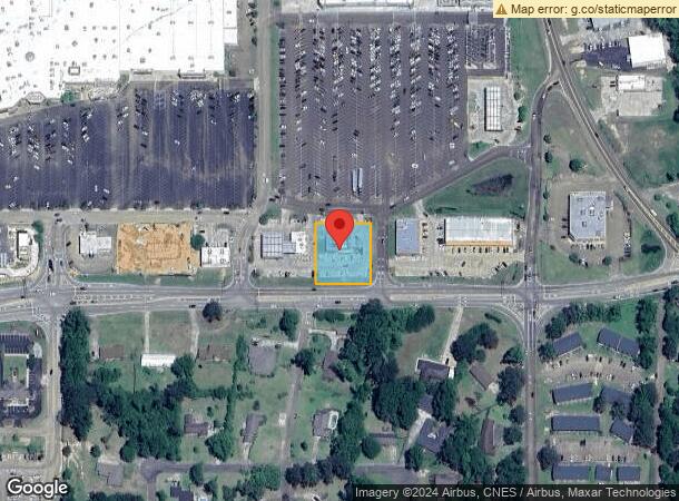
Property Record
Edgewood Dr, Mccomb, MS 39648
NEARBY LISTINGS FOR SALE OR LEASE
Property Detail
Edgewood Dr
592902-A
Edgewood Indefinite Sec 1 & 2-3-7
Restaurantbuilding
TCT IN NE1/4 NW1/4 N OF HWY 570 SPLIT FROM 592902 ZN:X-28113C0038C
X
Pike
28113C0038C
Mississippi
0
0.67 AC
2024
Other Market Areas
950300
McComb, MS
3,173 SF
DEMOGRAPHICS near Edgewood Dr
1 Mile
3 Mile
5 Mile
2024 Total Population
2,123
16,765
22,412
2029 Population
2,042
16,377
21,863
Pop Growth 2024-2029
(3.82%)
(2.31%)
(2.45%)
Average Age
45
39
39
2024 Total Households
915
6,733
8,905
HH Growth 2024-2029
(3.83%)
(2.26%)
(2.37%)
Median Household Inc
$37,027
$35,004
$37,048
Avg Household Size
2.10
2.30
2.40
2024 Avg HH Vehicles
2.00
2.00
2.00
Median Home Value
$175,140
$99,033
$121,196
Median Year Built
1976
1978
1980
Nearby Places
- Restaurants
- Banks
- Shops
- Fitness
- Groceries
PUBLIC TRANSPORTATION
COMMUTER RAIL
Mccomb (City of New Orleans - Amtrak)
Drive
Walk
Distance
Mccomb (City of New Orleans - Amtrak)
4 min
2.3 mi
Freight Ports
Port of Greater Baton Rouge
Drive
Walk
Distance
Port of Greater Baton Rouge
114 min
100.5 mi
SALE & LEASE HISTORY
LISTING DATE
SALE/LEASE

Sep 25, 2016
For Lease
Mar 01, 2017
For Lease
Feb 24, 2017
For Sale
Dec 17, 2018
For Sale
Nearby Properties
Address
Land Use
TOTAL SIZE
Lot Size
Zoning
Address
Land Use
TOTAL SIZE
Lot Size
Zoning
171,178 SF
Address
Land Use
TOTAL SIZE
Lot Size
Zoning
70,328 SF
9.12 AC
Address
Land Use
TOTAL SIZE
Lot Size
Zoning
21,390 SF
12.37 AC
Address
Land Use
TOTAL SIZE
Lot Size
Zoning
21,390 SF
6.04 AC
Address
Land Use
TOTAL SIZE
Lot Size
Zoning
49,490 SF
2.38 AC
C2
Address
Land Use
TOTAL SIZE
Lot Size
Zoning
1,696 SF
10.20 AC
IPL
Address
Land Use
TOTAL SIZE
Lot Size
Zoning
6,688 SF
0.26 AC
Address
Land Use
TOTAL SIZE
Lot Size
Zoning
28,063 SF
4.40 AC
C2
Address
Land Use
TOTAL SIZE
Lot Size
Zoning
187,639 SF
1 AC
CPL
Address
Land Use
TOTAL SIZE
Lot Size
Zoning
25,114 SF
4.14 AC
C1
Address
Land Use
TOTAL SIZE
Lot Size
Zoning
48,107 SF
3.80 AC
C1
Address
Land Use
TOTAL SIZE
Lot Size
Zoning
32,565 SF
Address
Land Use
TOTAL SIZE
Lot Size
Zoning
43,457 SF
7.22 AC
RPL
Address
Land Use
TOTAL SIZE
Lot Size
Zoning
56,352 SF
5.78 AC
Address
Land Use
TOTAL SIZE
Lot Size
Zoning
35,177 SF
1.36 AC
C2
Address
Land Use
TOTAL SIZE
Lot Size
Zoning
97,627 SF
1 AC
CPL
Address
Land Use
TOTAL SIZE
Lot Size
Zoning
12,092 SF
12.24 AC
Address
Land Use
TOTAL SIZE
Lot Size
Zoning
50,507 SF
3.97 AC
SOM
Address
Land Use
TOTAL SIZE
Lot Size
Zoning
12,938 SF
5.26 AC
C2
Address
Land Use
TOTAL SIZE
Lot Size
Zoning
28,857 SF
1.01 AC
C2
Address
Land Use
TOTAL SIZE
Lot Size
Zoning
14,246 SF
2.56 AC
CPL
Address
Land Use
TOTAL SIZE
Lot Size
Zoning
4,397 SF
10 AC
RPL
Address
Land Use
TOTAL SIZE
Lot Size
Zoning
16,835 SF
0.75 AC
Address
Land Use
TOTAL SIZE
Lot Size
Zoning
30,551 SF
2 AC
C2
Address
Land Use
TOTAL SIZE
Lot Size
Zoning
12,211 SF
2.72 AC
C2
Address
Land Use
TOTAL SIZE
Lot Size
Zoning
2,659 SF
6.43 AC
R80
Address
Land Use
TOTAL SIZE
Lot Size
Zoning
5,524 SF
4.72 AC
RPL
Address
Land Use
TOTAL SIZE
Lot Size
Zoning
45,002 SF
6.71 AC
RPL
Address
Land Use
TOTAL SIZE
Lot Size
Zoning
5,146 SF
1.38 AC
Address
Land Use
TOTAL SIZE
Lot Size
Zoning
21,681 SF
2.90 AC
RPL
Start a new search to find other properties for sale or lease
Connect with us
© 2024 CoStar Group
The information above has been obtained from sources believed reliable. While we do not doubt its accuracy we have not verified it and make no guarantee, warranty or representation about it. It is your responsibility to independently confirm its accuracy and completeness. Any projections, opinions, assumptions, or estimates used are for example only and do not represent the current or future performance of the property. The value of this transaction to you depends on tax and other factors which should be evaluated by your tax, financial, and legal advisors. You and your advisors should conduct a careful, independent investigation of the property to determine to your satisfaction the suitability of the property for your needs.