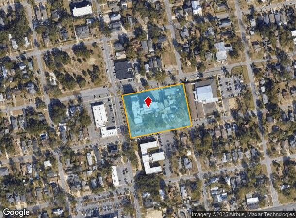
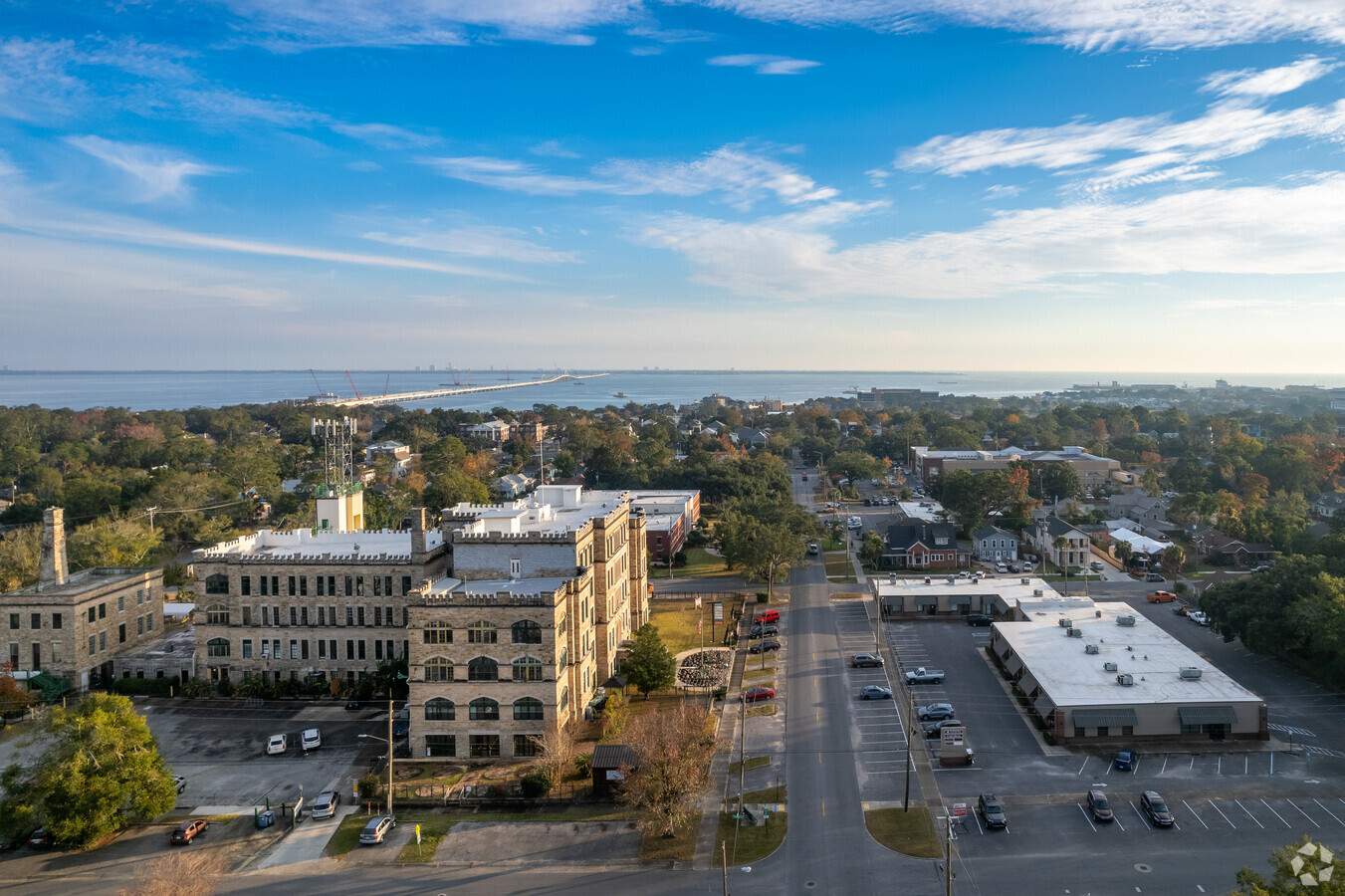
Property Record
1010 N 12Th Ave, Pensacola, FL 32501


Current Lease Availabilities
NEARBY LISTINGS FOR SALE OR LEASE
Property Detail
1010 N 12Th Ave
Pensacola-Ferry Pass-Brent, FL
New City Tract
00-0S-00-9025-002-135
ALL BLK 135 NEW CITY TRACT OR 4187 P 110 THAT PORTION OF VACATED 13TH AVE ADJOINING PROPERTY ORDINANCE 41-73 CA 49 ALSO ADJ VAC R/W (E DESOTO ST) OR 3622 P 560 CA 49
Officebuilding
Escambia
X
Florida
12033C0390G
2
2023
2.70 AC
2024
Central Pensacola/S Brent
000801
Pensacola
92,430 SF
DEMOGRAPHICS near 1010 N 12Th Ave
1 Mile
3 Mile
5 Mile
2024 Total Population
7,717
43,545
104,344
2029 Population
7,972
44,913
107,563
Pop Growth 2024-2029
+ 3.30%
+ 3.14%
+ 3.08%
Average Age
42
41
39
2024 Total Households
3,562
18,864
42,005
HH Growth 2024-2029
+ 3.31%
+ 3.18%
+ 3.18%
Median Household Inc
$60,822
$46,278
$46,265
Avg Household Size
2.00
2.10
2.20
2024 Avg HH Vehicles
2.00
2.00
2.00
Median Home Value
$301,335
$255,724
$208,002
Median Year Built
1953
1964
1969
Nearby Places
- Restaurants
- Banks
- Shops
- Fitness
- Groceries
PUBLIC TRANSPORTATION
AIRPORT
Pensacola International
DRIVE
WALK
Distance
Pensacola International
11 min
4.3 mi
Freight Ports
Port of Mobile
DRIVE
WALK
Distance
Port of Mobile
69 min
59.2 mi
Nearby Properties
Address
Land Use
TOTAL SIZE
Lot Size
Zoning
Address
Land Use
TOTAL SIZE
Lot Size
Zoning
544,835 SF
3.29 AC
C-2,C-2A
Address
Land Use
TOTAL SIZE
Lot Size
Zoning
365,037 SF
5.79 AC
C-3
Address
Land Use
TOTAL SIZE
Lot Size
Zoning
296,361 SF
13.03 AC
GRD
Address
Land Use
TOTAL SIZE
Lot Size
Zoning
368,724 SF
3.17 AC
C-2A
Address
Land Use
TOTAL SIZE
Lot Size
Zoning
56,970 SF
5.94 AC
WRD
Address
Land Use
TOTAL SIZE
Lot Size
Zoning
289,397 SF
12.38 AC
PUB
Address
Land Use
TOTAL SIZE
Lot Size
Zoning
197,545 SF
8.60 AC
R-2A
Address
Land Use
TOTAL SIZE
Lot Size
Zoning
158,425 SF
9.77 AC
R-2A
Address
Land Use
TOTAL SIZE
Lot Size
Zoning
353,428 SF
30.10 AC
M-1
Address
Land Use
TOTAL SIZE
Lot Size
Zoning
155,886 SF
5.98 AC
R-2
Address
Land Use
TOTAL SIZE
Lot Size
Zoning
327,045 SF
7.47 AC
C-2A
Address
Land Use
TOTAL SIZE
Lot Size
Zoning
178,451 SF
3.88 AC
GRD
Address
Land Use
TOTAL SIZE
Lot Size
Zoning
114,000 SF
3.23 AC
C-2,C-2A
Address
Land Use
TOTAL SIZE
Lot Size
Zoning
96,686 SF
1.06 AC
C-2A
Address
Land Use
TOTAL SIZE
Lot Size
Zoning
156,182 SF
7.90 AC
R-2
Address
Land Use
TOTAL SIZE
Lot Size
Zoning
282,738 SF
14.64 AC
PUB
Address
Land Use
TOTAL SIZE
Lot Size
Zoning
258,438 SF
48.49 AC
PUB
Address
Land Use
TOTAL SIZE
Lot Size
Zoning
99,623 SF
1.87 AC
C-2A
Address
Land Use
TOTAL SIZE
Lot Size
Zoning
145,264 SF
9.84 AC
SSD
Address
Land Use
TOTAL SIZE
Lot Size
Zoning
115,500 SF
3.48 AC
C-2
Address
Land Use
TOTAL SIZE
Lot Size
Zoning
166,204 SF
0.97 AC
C-2A
Address
Land Use
TOTAL SIZE
Lot Size
Zoning
75,877 SF
1.55 AC
WRD
Address
Land Use
TOTAL SIZE
Lot Size
Zoning
171,446 SF
14.83 AC
R-2A
Address
Land Use
TOTAL SIZE
Lot Size
Zoning
130,516 SF
4.55 AC
R-2
Address
Land Use
TOTAL SIZE
Lot Size
Zoning
55,337 SF
0.95 AC
C-2A,HC-2
Address
Land Use
TOTAL SIZE
Lot Size
Zoning
81,549 SF
0.46 AC
WRD
Address
Land Use
TOTAL SIZE
Lot Size
Zoning
73,923 SF
2.87 AC
GRD
Address
Land Use
TOTAL SIZE
Lot Size
Zoning
254,937 SF
39.66 AC
R-1AA
Address
Land Use
TOTAL SIZE
Lot Size
Zoning
146,790 SF
8.83 AC
C-1,C-3
Address
Land Use
TOTAL SIZE
Lot Size
Zoning
56,354 SF
3.25 AC
HC-1
The World's #1 Commercial Real Estate Marketplace
Connect with us
© 2025 CoStar Group
The information above has been obtained from sources believed reliable. While we do not doubt its accuracy we have not verified it and make no guarantee, warranty or representation about it. It is your responsibility to independently confirm its accuracy and completeness. Any projections, opinions, assumptions, or estimates used are for example only and do not represent the current or future performance of the property. The value of this transaction to you depends on tax and other factors which should be evaluated by your tax, financial, and legal advisors. You and your advisors should conduct a careful, independent investigation of the property to determine to your satisfaction the suitability of the property for your needs.