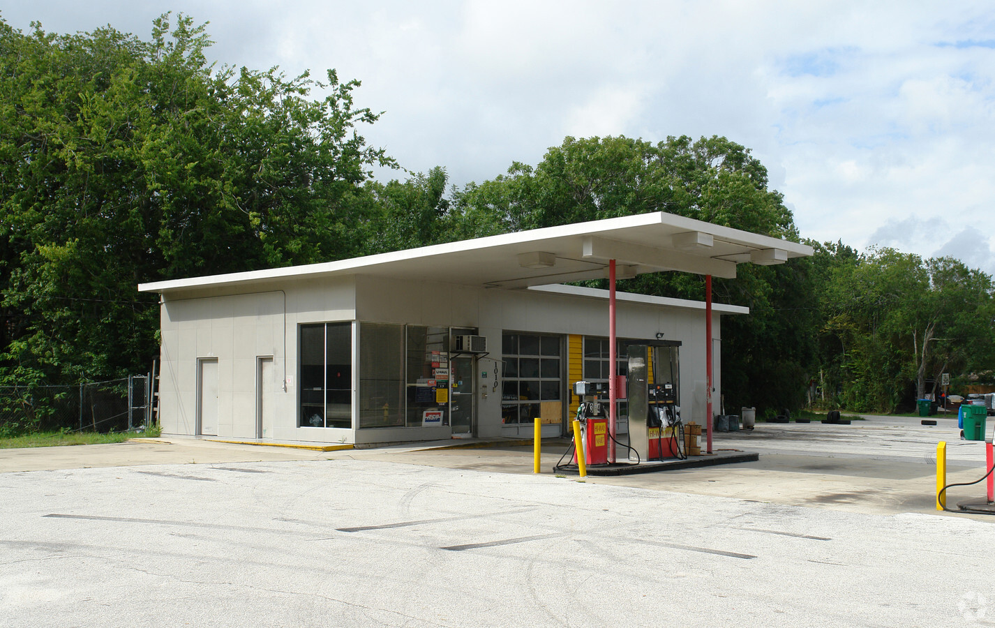
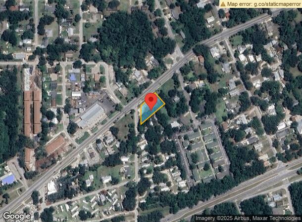
Property Record
1010 Canal St, New Smyrna Beach, FL 32168

NEARBY LISTINGS FOR SALE OR LEASE
Property Detail
1010 Canal St
Deltona-Daytona Beach-Ormond Beach, FL
Sapps Resub
7419-08-00-0040
PART OF LOTS 3 4 & 5 BEING 112.13 FT ON E/L & 210.36 FT ON S/L & 147.36 FT ON W/L & 141.4 FT ON N/L PER OR 0884 PG 0054 MB 19 PG 7 SAPPS RESUB PER OR 3287 PG 0944 PER OR 5857 PGS 1034-1035 PER OR 5853 PGS 1027-1028 PER OR 5859 PG 2362 PER OR 7691 PG
Commercialacreage
Volusia
AE
Florida
12127C0543J
3
2023
0.45 AC
2025
South Beach Cities
082903
Deltona/Daytona Beach
DEMOGRAPHICS near 1010 Canal St
1 Mile
3 Mile
5 Mile
2024 Total Population
6,675
29,074
56,655
2029 Population
7,436
32,771
64,097
Pop Growth 2024-2029
+ 11.40%
+ 12.72%
+ 13.14%
Average Age
47
50
50
2024 Total Households
3,025
13,610
26,509
HH Growth 2024-2029
+ 11.60%
+ 13.04%
+ 13.53%
Median Household Inc
$46,538
$59,697
$60,478
Avg Household Size
2.00
2.00
2.10
2024 Avg HH Vehicles
1.00
2.00
2.00
Median Home Value
$223,191
$292,619
$281,031
Median Year Built
1976
1984
1985
Nearby Places
- Restaurants
- Banks
- Shops
- Fitness
- Groceries
PUBLIC TRANSPORTATION
AIRPORT
Daytona Beach International
DRIVE
WALK
Distance
Daytona Beach International
26 min
18.0 mi
Orlando Sanford International
DRIVE
WALK
Distance
Orlando Sanford International
46 min
31.8 mi
Freight Ports
Port Canaveral
DRIVE
WALK
Distance
Port Canaveral
72 min
60.5 mi
Nearby Properties
Address
Land Use
TOTAL SIZE
Lot Size
Zoning
Address
Land Use
TOTAL SIZE
Lot Size
Zoning
317,281 SF
21.97 AC
RR
Address
Land Use
TOTAL SIZE
Lot Size
Zoning
360,394 SF
65.63 AC
01R4
Address
Land Use
TOTAL SIZE
Lot Size
Zoning
177,619 SF
6.91 AC
10R2
Address
Land Use
TOTAL SIZE
Lot Size
Zoning
260,126 SF
2 AC
10R3
Address
Land Use
TOTAL SIZE
Lot Size
Zoning
108,577 SF
20 AC
10R2
Address
Land Use
TOTAL SIZE
Lot Size
Zoning
209,027 SF
29.13 AC
10R2A
Address
Land Use
TOTAL SIZE
Lot Size
Zoning
115,562 SF
1.40 AC
10B4
Address
Land Use
TOTAL SIZE
Lot Size
Zoning
70,564 SF
2.09 AC
10B1
Address
Land Use
TOTAL SIZE
Lot Size
Zoning
150,044 SF
19.80 AC
R4
Address
Land Use
TOTAL SIZE
Lot Size
Zoning
134,246 SF
13.58 AC
10B5
Address
Land Use
TOTAL SIZE
Lot Size
Zoning
0.20 AC
B46
Address
Land Use
TOTAL SIZE
Lot Size
Zoning
89,919 SF
1.49 AC
10B4
Address
Land Use
TOTAL SIZE
Lot Size
Zoning
23,142 SF
7.98 AC
R
Address
Land Use
TOTAL SIZE
Lot Size
Zoning
7,345 SF
0.43 AC
MH1
Address
Land Use
TOTAL SIZE
Lot Size
Zoning
11.87 AC
10R2A
Address
Land Use
TOTAL SIZE
Lot Size
Zoning
Address
Land Use
TOTAL SIZE
Lot Size
Zoning
110,926 SF
7.02 AC
Address
Land Use
TOTAL SIZE
Lot Size
Zoning
91,509 SF
4.06 AC
I1
Address
Land Use
TOTAL SIZE
Lot Size
Zoning
87,154 SF
1.08 AC
10R5
Address
Land Use
TOTAL SIZE
Lot Size
Zoning
94,251 SF
18.51 AC
Address
Land Use
TOTAL SIZE
Lot Size
Zoning
43,852 SF
8.81 AC
RR
Address
Land Use
TOTAL SIZE
Lot Size
Zoning
39,971 SF
281.52 AC
10I3
Address
Land Use
TOTAL SIZE
Lot Size
Zoning
47,434 SF
11.41 AC
10R3
Address
Land Use
TOTAL SIZE
Lot Size
Zoning
115,028 SF
16.51 AC
R4
Address
Land Use
TOTAL SIZE
Lot Size
Zoning
111,686 SF
10.03 AC
10B5
Address
Land Use
TOTAL SIZE
Lot Size
Zoning
74,609 SF
12.67 AC
10B3
Address
Land Use
TOTAL SIZE
Lot Size
Zoning
229,941 SF
0.57 AC
10R2A
Address
Land Use
TOTAL SIZE
Lot Size
Zoning
55,587 SF
85.39 AC
R4
Address
Land Use
TOTAL SIZE
Lot Size
Zoning
119,537 SF
12.06 AC
PUD
Address
Land Use
TOTAL SIZE
Lot Size
Zoning
91,759 SF
10.15 AC
10B2
The World's #1 Commercial Real Estate Marketplace
Connect with us
© 2025 CoStar Group
The information above has been obtained from sources believed reliable. While we do not doubt its accuracy we have not verified it and make no guarantee, warranty or representation about it. It is your responsibility to independently confirm its accuracy and completeness. Any projections, opinions, assumptions, or estimates used are for example only and do not represent the current or future performance of the property. The value of this transaction to you depends on tax and other factors which should be evaluated by your tax, financial, and legal advisors. You and your advisors should conduct a careful, independent investigation of the property to determine to your satisfaction the suitability of the property for your needs.