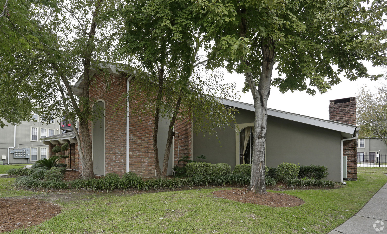
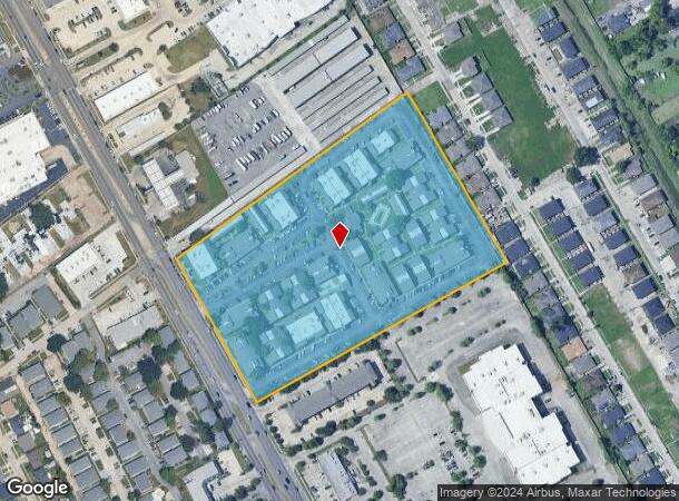
Property Record
1013 Manhattan Blvd, Harvey, LA 70058

NEARBY LISTINGS FOR SALE OR LEASE
Property Detail
1013 Manhattan Blvd
New Orleans-Metairie, LA
Hunt Foods & Wesson Oil & Snowdrift Co
0300000419
LESS PORT EXPROPRIATED 11727344 HUNT FOOD IND TRACT
Realpropertynec
Jefferson
X
Louisiana
22051C0215F
k2
2023
10.90 AC
2023
Westbank
026100
New Orleans/Metairie/Kenner
DEMOGRAPHICS near 1013 Manhattan Blvd
1 Mile
3 Mile
5 Mile
2024 Total Population
14,889
124,136
316,433
2029 Population
14,376
119,718
305,369
Pop Growth 2024-2029
(3.45%)
(3.56%)
(3.50%)
Average Age
38
40
40
2024 Total Households
5,914
52,652
133,464
HH Growth 2024-2029
(3.60%)
(3.61%)
(3.41%)
Median Household Inc
$34,336
$52,989
$54,218
Avg Household Size
2.40
2.30
2.20
2024 Avg HH Vehicles
1.00
1.00
1.00
Median Home Value
$165,948
$221,561
$241,232
Median Year Built
1968
1969
1965
Nearby Places
- Restaurants
- Banks
- Shops
- Fitness
- Groceries
PUBLIC TRANSPORTATION
COMMUTER RAIL
New Orleans Union Passenger Terminal (City of New Orleans - Amtrak, Crescent - Amtrak, Sunset Limited - Amtrak)
Drive
Walk
Distance
New Orleans Union Passenger Terminal (City of New Orleans - Amtrak, Crescent - Amtrak, Sunset Limited - Amtrak)
10 min
6.4 mi
AIRPORT
Louis Armstrong New Orleans International
Drive
Walk
Distance
Louis Armstrong New Orleans International
29 min
20.7 mi
Freight Ports
Port of New Orleans
Drive
Walk
Distance
Port of New Orleans
15 min
7.1 mi
Nearby Properties
Address
Land Use
TOTAL SIZE
Lot Size
Zoning
Address
Land Use
TOTAL SIZE
Lot Size
Zoning
Address
Land Use
TOTAL SIZE
Lot Size
Zoning
3.66 AC
Address
Land Use
TOTAL SIZE
Lot Size
Zoning
Address
Land Use
TOTAL SIZE
Lot Size
Zoning
114083
5.35 AC
Address
Land Use
TOTAL SIZE
Lot Size
Zoning
Address
Land Use
TOTAL SIZE
Lot Size
Zoning
444121
1.46 AC
Address
Land Use
TOTAL SIZE
Lot Size
Zoning
512729
1 AC
Address
Land Use
TOTAL SIZE
Lot Size
Zoning
Address
Land Use
TOTAL SIZE
Lot Size
Zoning
Address
Land Use
TOTAL SIZE
Lot Size
Zoning
2.94 AC
Address
Land Use
TOTAL SIZE
Lot Size
Zoning
4.12 AC
Address
Land Use
TOTAL SIZE
Lot Size
Zoning
25.26 AC
Address
Land Use
TOTAL SIZE
Lot Size
Zoning
Address
Land Use
TOTAL SIZE
Lot Size
Zoning
121349
0.85 AC
Address
Land Use
TOTAL SIZE
Lot Size
Zoning
151320
27.55 AC
Address
Land Use
TOTAL SIZE
Lot Size
Zoning
222425
1.11 AC
Address
Land Use
TOTAL SIZE
Lot Size
Zoning
109688
8.77 AC
Address
Land Use
TOTAL SIZE
Lot Size
Zoning
Address
Land Use
TOTAL SIZE
Lot Size
Zoning
23.90 AC
Address
Land Use
TOTAL SIZE
Lot Size
Zoning
Address
Land Use
TOTAL SIZE
Lot Size
Zoning
188935
1.12 AC
Address
Land Use
TOTAL SIZE
Lot Size
Zoning
Address
Land Use
TOTAL SIZE
Lot Size
Zoning
Address
Land Use
TOTAL SIZE
Lot Size
Zoning
53036
2.81 AC
Address
Land Use
TOTAL SIZE
Lot Size
Zoning
Address
Land Use
TOTAL SIZE
Lot Size
Zoning
14.69 AC
Address
Land Use
TOTAL SIZE
Lot Size
Zoning
3.55 AC
Address
Land Use
TOTAL SIZE
Lot Size
Zoning
12.79 AC
Address
Land Use
TOTAL SIZE
Lot Size
Zoning
Address
Land Use
TOTAL SIZE
Lot Size
Zoning
207220
0.40 AC
Start a new search to find other properties for sale or lease
Connect with us
© 2024 CoStar Group
The information above has been obtained from sources believed reliable. While we do not doubt its accuracy we have not verified it and make no guarantee, warranty or representation about it. It is your responsibility to independently confirm its accuracy and completeness. Any projections, opinions, assumptions, or estimates used are for example only and do not represent the current or future performance of the property. The value of this transaction to you depends on tax and other factors which should be evaluated by your tax, financial, and legal advisors. You and your advisors should conduct a careful, independent investigation of the property to determine to your satisfaction the suitability of the property for your needs.