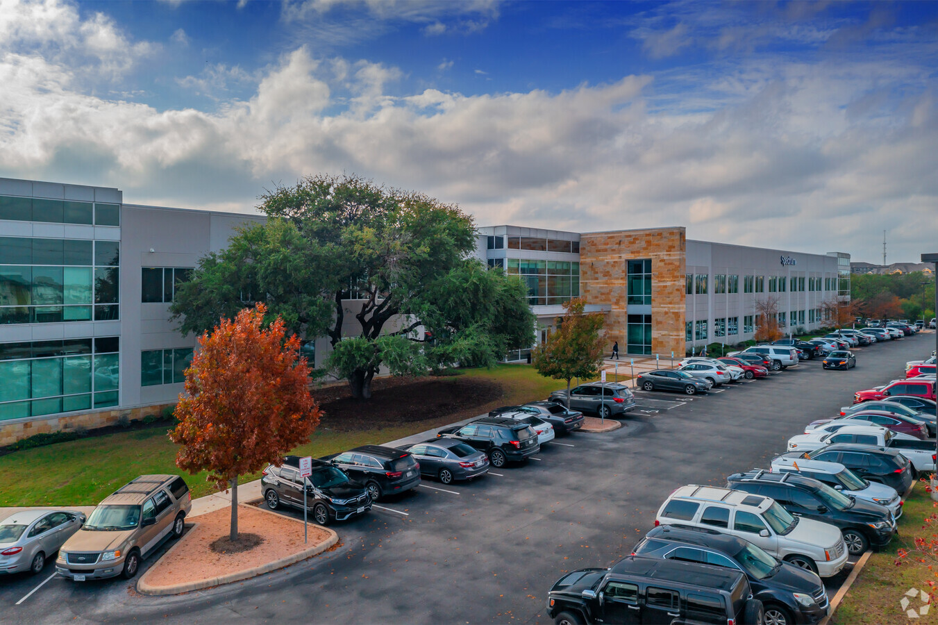
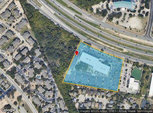
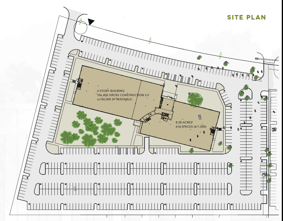
Property Record
10130 State Highway 151, San Antonio, TX 78251
Current Lease Availabilities
NEARBY LISTINGS FOR SALE OR LEASE
Property Detail
10130 State Highway 151
San Antonio-New Braunfels, TX
Ncb 17642 (Westover Hill, Ut-49
17642-001-0980
NCB 17642 (WESTOVER HILL, UT-49, BLOCK 1 LOT 98 2015 NEW ACCT PER PLAT 9674/210-4 FILED 10/10/2014
Officebuilding
Bexar
X
Texas
48029C0360G
98
2023
8.28 AC
2023
Far West
171918
San Antonio
105,107 SF
DEMOGRAPHICS near 10130 State Highway 151
1 Mile
3 Mile
5 Mile
2024 Total Population
16,767
120,221
305,050
2029 Population
17,689
127,271
324,592
Pop Growth 2024-2029
+ 5.50%
+ 5.86%
+ 6.41%
Average Age
34
35
35
2024 Total Households
6,081
42,262
104,786
HH Growth 2024-2029
+ 5.82%
+ 5.99%
+ 6.56%
Median Household Inc
$73,663
$71,798
$71,325
Avg Household Size
2.70
2.80
2.90
2024 Avg HH Vehicles
2.00
2.00
2.00
Median Home Value
$214,244
$202,983
$202,237
Median Year Built
2004
2001
1999
Nearby Places
- Restaurants
- Banks
- Shops
- Fitness
- Groceries
PUBLIC TRANSPORTATION
AIRPORT
San Antonio International
DRIVE
WALK
Distance
San Antonio International
20 min
15.6 mi
Freight Ports
Port of Corpus Christi
DRIVE
WALK
Distance
Port of Corpus Christi
160 min
154.4 mi
Nearby Properties
Address
Land Use
TOTAL SIZE
Lot Size
Zoning
Address
Land Use
TOTAL SIZE
Lot Size
Zoning
480,488 SF
21.60 AC
Address
Land Use
TOTAL SIZE
Lot Size
Zoning
754,713 SF
33.44 AC
Address
Land Use
TOTAL SIZE
Lot Size
Zoning
738,286 SF
44 SF
Address
Land Use
TOTAL SIZE
Lot Size
Zoning
1,963,350 SF
36.24 AC
Address
Land Use
TOTAL SIZE
Lot Size
Zoning
333,308 SF
22.04 AC
Address
Land Use
TOTAL SIZE
Lot Size
Zoning
315,000 SF
24.20 AC
Address
Land Use
TOTAL SIZE
Lot Size
Zoning
339,795 SF
24.27 AC
Address
Land Use
TOTAL SIZE
Lot Size
Zoning
443,726 SF
25.01 AC
Address
Land Use
TOTAL SIZE
Lot Size
Zoning
469,808 SF
36 AC
Address
Land Use
TOTAL SIZE
Lot Size
Zoning
593,760 SF
69.28 AC
Address
Land Use
TOTAL SIZE
Lot Size
Zoning
236,594 SF
25.34 AC
Address
Land Use
TOTAL SIZE
Lot Size
Zoning
185,751 SF
21.60 AC
Address
Land Use
TOTAL SIZE
Lot Size
Zoning
361,366 SF
66.88 AC
Address
Land Use
TOTAL SIZE
Lot Size
Zoning
171,142 SF
21.60 AC
Address
Land Use
TOTAL SIZE
Lot Size
Zoning
532,921 SF
21.80 AC
Address
Land Use
TOTAL SIZE
Lot Size
Zoning
331,109 SF
14.44 AC
Address
Land Use
TOTAL SIZE
Lot Size
Zoning
302,851 SF
14.98 AC
Address
Land Use
TOTAL SIZE
Lot Size
Zoning
336,383 SF
18.71 AC
Address
Land Use
TOTAL SIZE
Lot Size
Zoning
275,270 SF
11.97 AC
Address
Land Use
TOTAL SIZE
Lot Size
Zoning
815,030 SF
111.97 AC
Address
Land Use
TOTAL SIZE
Lot Size
Zoning
361,708 SF
17.83 AC
Address
Land Use
TOTAL SIZE
Lot Size
Zoning
118,393 SF
28.05 AC
Address
Land Use
TOTAL SIZE
Lot Size
Zoning
50,135 SF
10.96 AC
Address
Land Use
TOTAL SIZE
Lot Size
Zoning
202,122 SF
20.56 AC
Address
Land Use
TOTAL SIZE
Lot Size
Zoning
360,108 SF
24 AC
Address
Land Use
TOTAL SIZE
Lot Size
Zoning
368,012 SF
22.27 AC
Address
Land Use
TOTAL SIZE
Lot Size
Zoning
369,951 SF
21.42 AC
Address
Land Use
TOTAL SIZE
Lot Size
Zoning
109,425 SF
30.63 AC
Address
Land Use
TOTAL SIZE
Lot Size
Zoning
123,595 SF
21.60 AC
Address
Land Use
TOTAL SIZE
Lot Size
Zoning
241,445 SF
15.86 AC
The World's #1 Commercial Real Estate Marketplace
Connect with us
© 2025 CoStar Group
The information above has been obtained from sources believed reliable. While we do not doubt its accuracy we have not verified it and make no guarantee, warranty or representation about it. It is your responsibility to independently confirm its accuracy and completeness. Any projections, opinions, assumptions, or estimates used are for example only and do not represent the current or future performance of the property. The value of this transaction to you depends on tax and other factors which should be evaluated by your tax, financial, and legal advisors. You and your advisors should conduct a careful, independent investigation of the property to determine to your satisfaction the suitability of the property for your needs.