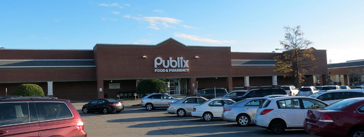
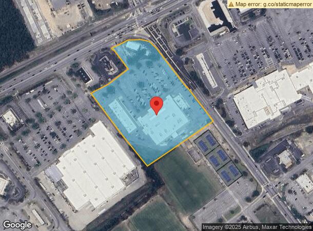
Property Record
10134 Two Notch Rd, Columbia, SC 29223

NEARBY LISTINGS FOR SALE OR LEASE
Property Detail
10134 Two Notch Rd
22808-02-05
113.7X80.9X58.3X62.2X312.1X271 X507.2X583.9X124.9X155.1XETC #SU
Commercialnec
Richland
X
South Carolina
45079C0257L
7.35 AC
2024
Northeast Columbia
2023
Columbia
011413
Columbia, SC
71,170 SF
DEMOGRAPHICS near 10134 Two Notch Rd
1 Mile
3 Mile
5 Mile
2024 Total Population
5,398
51,395
110,808
2029 Population
5,428
51,908
112,480
Pop Growth 2024-2029
+ 0.56%
+ 1.00%
+ 1.51%
Average Age
43
39
38
2024 Total Households
2,279
20,570
43,474
HH Growth 2024-2029
+ 0.75%
+ 1.08%
+ 1.57%
Median Household Inc
$88,011
$69,298
$66,067
Avg Household Size
2.30
2.50
2.50
2024 Avg HH Vehicles
2.00
2.00
2.00
Median Home Value
$250,191
$205,631
$203,144
Median Year Built
1990
1997
2000
Nearby Places
- Restaurants
- Banks
- Shops
- Fitness
- Groceries
PUBLIC TRANSPORTATION
AIRPORT
Columbia Metro
DRIVE
WALK
Distance
Columbia Metro
42 min
24.1 mi
Freight Ports
North Charleston Terminal
DRIVE
WALK
Distance
North Charleston Terminal
138 min
119.7 mi
Nearby Properties
Address
Land Use
TOTAL SIZE
Lot Size
Zoning
Address
Land Use
TOTAL SIZE
Lot Size
Zoning
244,269 SF
9.54 AC
GC
Address
Land Use
TOTAL SIZE
Lot Size
Zoning
563.44 AC
OI
Address
Land Use
TOTAL SIZE
Lot Size
Zoning
329,677 SF
17.12 AC
PDD
Address
Land Use
TOTAL SIZE
Lot Size
Zoning
343,506 SF
29.94 AC
RM-HD
Address
Land Use
TOTAL SIZE
Lot Size
Zoning
313,664 SF
33.91 AC
RG-2
Address
Land Use
TOTAL SIZE
Lot Size
Zoning
299,353 SF
12.36 AC
GC
Address
Land Use
TOTAL SIZE
Lot Size
Zoning
333,002 SF
8.39 AC
GC
Address
Land Use
TOTAL SIZE
Lot Size
Zoning
285,368 SF
16.09 AC
GC
Address
Land Use
TOTAL SIZE
Lot Size
Zoning
140,567 SF
16.98 AC
M-1
Address
Land Use
TOTAL SIZE
Lot Size
Zoning
62,878 SF
8.43 AC
RM-HD
Address
Land Use
TOTAL SIZE
Lot Size
Zoning
360,163 SF
20.11 AC
RM-MD
Address
Land Use
TOTAL SIZE
Lot Size
Zoning
147,916 SF
4.69 AC
OI
Address
Land Use
TOTAL SIZE
Lot Size
Zoning
179,808 SF
12.85 AC
RM-HD
Address
Land Use
TOTAL SIZE
Lot Size
Zoning
245,825 SF
11 AC
RS-2
Address
Land Use
TOTAL SIZE
Lot Size
Zoning
91,672 SF
12.18 AC
GC
Address
Land Use
TOTAL SIZE
Lot Size
Zoning
224,256 SF
25.49 AC
M-1
Address
Land Use
TOTAL SIZE
Lot Size
Zoning
31,625 SF
3.30 AC
GC
Address
Land Use
TOTAL SIZE
Lot Size
Zoning
66,821 SF
6.32 AC
OI
Address
Land Use
TOTAL SIZE
Lot Size
Zoning
73,192 SF
6.12 AC
GC
Address
Land Use
TOTAL SIZE
Lot Size
Zoning
138,480 SF
23.02 AC
GC
Address
Land Use
TOTAL SIZE
Lot Size
Zoning
249,536 SF
20.36 AC
RM-HD
Address
Land Use
TOTAL SIZE
Lot Size
Zoning
87,363 SF
10.61 AC
M-1
Address
Land Use
TOTAL SIZE
Lot Size
Zoning
84,860 SF
5.13 AC
PUD-R
Address
Land Use
TOTAL SIZE
Lot Size
Zoning
81,951 SF
11.81 AC
M-1
Address
Land Use
TOTAL SIZE
Lot Size
Zoning
194,728 SF
12.28 AC
RM-MD
Address
Land Use
TOTAL SIZE
Lot Size
Zoning
78,282 SF
8.52 AC
M-1
Address
Land Use
TOTAL SIZE
Lot Size
Zoning
161,727 SF
13.25 AC
GC
Address
Land Use
TOTAL SIZE
Lot Size
Zoning
143,072 SF
12.61 AC
PDD
Address
Land Use
TOTAL SIZE
Lot Size
Zoning
93,560 SF
9.39 AC
M-1
Address
Land Use
TOTAL SIZE
Lot Size
Zoning
53,984 SF
15 AC
C-3
The World's #1 Commercial Real Estate Marketplace
Connect with us
© 2025 CoStar Group
The information above has been obtained from sources believed reliable. While we do not doubt its accuracy we have not verified it and make no guarantee, warranty or representation about it. It is your responsibility to independently confirm its accuracy and completeness. Any projections, opinions, assumptions, or estimates used are for example only and do not represent the current or future performance of the property. The value of this transaction to you depends on tax and other factors which should be evaluated by your tax, financial, and legal advisors. You and your advisors should conduct a careful, independent investigation of the property to determine to your satisfaction the suitability of the property for your needs.