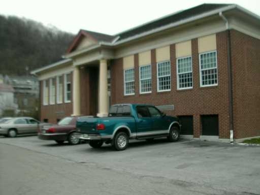
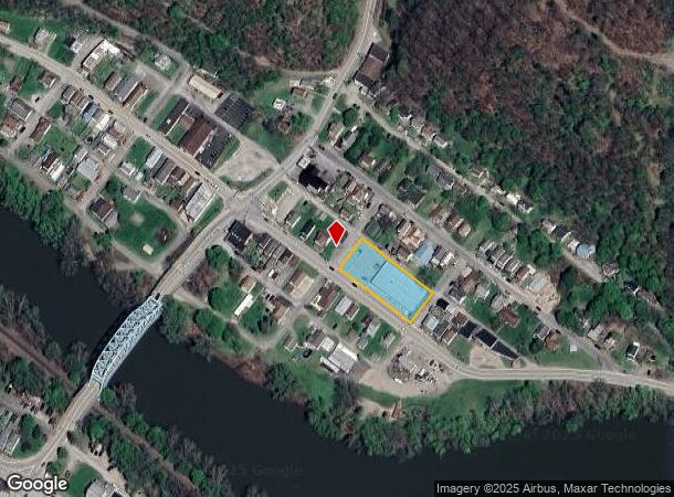
Property Record
1014 E 2Nd St, Vandergrift, PA 15690
NEARBY LISTINGS FOR SALE OR LEASE
Property Detail
1014 E 2Nd St
Pittsburgh, PA
Lot Addition A
35-0-025347
LOT 1 & LOT ADDITION A - IMPRS PB8 PG445-447 SL921-22
Wholesaleoutletdiscountstore
Armstrong
X
Pennsylvania
42005C0531D
1
2024
0.55 AC
2024
Armstrong County
951400
Pittsburgh
9,100 SF
DEMOGRAPHICS near 1014 E 2Nd St
1 Mile
3 Mile
5 Mile
2024 Total Population
5,687
20,063
28,262
2029 Population
5,701
19,917
27,974
Pop Growth 2024-2029
+ 0.25%
(0.73%)
(1.02%)
Average Age
41
43
44
2024 Total Households
2,472
8,720
12,233
HH Growth 2024-2029
+ 0.16%
(0.78%)
(1.06%)
Median Household Inc
$45,377
$51,019
$55,386
Avg Household Size
2.30
2.30
2.30
2024 Avg HH Vehicles
1.00
2.00
2.00
Median Home Value
$84,008
$104,879
$128,034
Median Year Built
1947
1951
1956
Nearby Places
- Restaurants
- Banks
- Shops
- Fitness
- Groceries
PUBLIC TRANSPORTATION
AIRPORT
Arnold Palmer Regional
DRIVE
WALK
Distance
Arnold Palmer Regional
56 min
32.0 mi
Freight Ports
Port of Baltimore
DRIVE
WALK
Distance
Port of Baltimore
293 min
245.6 mi
SALE & LEASE HISTORY
LISTING DATE
SALE/LEASE

Sep 24, 2016
For Sale
Nearby Properties
Address
Land Use
TOTAL SIZE
Lot Size
Zoning
Address
Land Use
TOTAL SIZE
Lot Size
Zoning
120,681 SF
2.97 AC
RESIDENTIA
Address
Land Use
TOTAL SIZE
Lot Size
Zoning
81,195 SF
7.65 AC
Address
Land Use
TOTAL SIZE
Lot Size
Zoning
0.43 AC
Address
Land Use
TOTAL SIZE
Lot Size
Zoning
14.10 AC
Address
Land Use
TOTAL SIZE
Lot Size
Zoning
64.20 AC
Address
Land Use
TOTAL SIZE
Lot Size
Zoning
77,590 SF
10.53 AC
Address
Land Use
TOTAL SIZE
Lot Size
Zoning
1,680 SF
38.28 AC
Address
Land Use
TOTAL SIZE
Lot Size
Zoning
48,148 SF
5.26 AC
Address
Land Use
TOTAL SIZE
Lot Size
Zoning
23,088 SF
1.54 AC
RESIDENTIA
Address
Land Use
TOTAL SIZE
Lot Size
Zoning
9.07 AC
Address
Land Use
TOTAL SIZE
Lot Size
Zoning
69,000 SF
7.09 AC
Address
Land Use
TOTAL SIZE
Lot Size
Zoning
44,062 SF
1.14 AC
LIGHT/INDU
Address
Land Use
TOTAL SIZE
Lot Size
Zoning
44,550 SF
0.33 AC
BUSINESS
Address
Land Use
TOTAL SIZE
Lot Size
Zoning
Address
Land Use
TOTAL SIZE
Lot Size
Zoning
19,701 SF
0.37 AC
RESIDENTIA
Address
Land Use
TOTAL SIZE
Lot Size
Zoning
19,150 SF
6.26 AC
RESIDENTIA
Address
Land Use
TOTAL SIZE
Lot Size
Zoning
9.60 AC
Address
Land Use
TOTAL SIZE
Lot Size
Zoning
28,600 SF
6.56 AC
Address
Land Use
TOTAL SIZE
Lot Size
Zoning
13,050 SF
Address
Land Use
TOTAL SIZE
Lot Size
Zoning
11,485 SF
2.42 AC
Address
Land Use
TOTAL SIZE
Lot Size
Zoning
3.40 AC
Address
Land Use
TOTAL SIZE
Lot Size
Zoning
17,440 SF
2.57 AC
Address
Land Use
TOTAL SIZE
Lot Size
Zoning
17,225 SF
0.45 AC
BUSINESS
Address
Land Use
TOTAL SIZE
Lot Size
Zoning
16,419 SF
0.35 AC
BUSINESS
Address
Land Use
TOTAL SIZE
Lot Size
Zoning
12,728 SF
2.50 AC
Address
Land Use
TOTAL SIZE
Lot Size
Zoning
41,596 SF
0.32 AC
RESIDENTIA
Address
Land Use
TOTAL SIZE
Lot Size
Zoning
15.80 AC
Address
Land Use
TOTAL SIZE
Lot Size
Zoning
1,250 SF
3.96 AC
RESIDENTIA
Address
Land Use
TOTAL SIZE
Lot Size
Zoning
10,640 SF
1.84 AC
BUSINESS
The World's #1 Commercial Real Estate Marketplace
Connect with us
© 2025 CoStar Group
The information above has been obtained from sources believed reliable. While we do not doubt its accuracy we have not verified it and make no guarantee, warranty or representation about it. It is your responsibility to independently confirm its accuracy and completeness. Any projections, opinions, assumptions, or estimates used are for example only and do not represent the current or future performance of the property. The value of this transaction to you depends on tax and other factors which should be evaluated by your tax, financial, and legal advisors. You and your advisors should conduct a careful, independent investigation of the property to determine to your satisfaction the suitability of the property for your needs.