Property Record
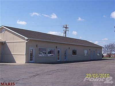
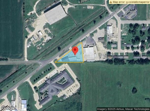
1014 W Highway 28, Owensville, MO 65066
NEARBY LISTINGS FOR SALE OR LEASE
Property Detail
1014 W Highway 28
14-9.0-32-002-004-002.000
5Th Principal Meridian
Miscellaneous
PT SW NW, S OF HWY 28, CITY OWENSVILLE: AC-1.00
X
Gasconade
29073C0350D
Missouri
2024
2.34 AC
2024
Missouri South Central Area
960500
Other Market Areas
4,105 SF
DEMOGRAPHICS near 1014 W Highway 28
1 Mile
3 Mile
5 Mile
2024 Total Population
1,444
4,077
4,979
2029 Population
1,417
4,006
4,892
Pop Growth 2024-2029
(1.87%)
(1.74%)
(1.75%)
Average Age
42
42
42
2024 Total Households
608
1,670
2,018
HH Growth 2024-2029
(1.97%)
(1.74%)
(1.78%)
Median Household Inc
$54,347
$51,292
$54,780
Avg Household Size
2.30
2.40
2.40
2024 Avg HH Vehicles
2.00
2.00
2.00
Median Home Value
$132,051
$136,686
$141,567
Median Year Built
1970
1970
1971
Nearby Places
- Restaurants
- Banks
- Shops
- Fitness
- Groceries
Nearby Properties
Address
Land Use
TOTAL SIZE
Lot Size
Zoning
Address
Land Use
TOTAL SIZE
Lot Size
Zoning
147,730 SF
8.39 AC
Address
Land Use
TOTAL SIZE
Lot Size
Zoning
46,480 SF
11.06 AC
Address
Land Use
TOTAL SIZE
Lot Size
Zoning
53,125 SF
7.66 AC
Address
Land Use
TOTAL SIZE
Lot Size
Zoning
100,046 SF
16.52 AC
Address
Land Use
TOTAL SIZE
Lot Size
Zoning
6,837 SF
1.97 AC
Address
Land Use
TOTAL SIZE
Lot Size
Zoning
4,674 SF
0.69 AC
Address
Land Use
TOTAL SIZE
Lot Size
Zoning
15,856 SF
3.55 AC
Address
Land Use
TOTAL SIZE
Lot Size
Zoning
60,272 SF
7.43 AC
Address
Land Use
TOTAL SIZE
Lot Size
Zoning
59,041 SF
5.73 AC
Address
Land Use
TOTAL SIZE
Lot Size
Zoning
29,029 SF
2.68 AC
Address
Land Use
TOTAL SIZE
Lot Size
Zoning
9,936 SF
4.90 AC
Address
Land Use
TOTAL SIZE
Lot Size
Zoning
4,181 SF
0.53 AC
Address
Land Use
TOTAL SIZE
Lot Size
Zoning
11,700 SF
1.73 AC
Address
Land Use
TOTAL SIZE
Lot Size
Zoning
8,000 SF
1.41 AC
Address
Land Use
TOTAL SIZE
Lot Size
Zoning
24,000 SF
6.39 AC
Address
Land Use
TOTAL SIZE
Lot Size
Zoning
4,080 SF
0.64 AC
Address
Land Use
TOTAL SIZE
Lot Size
Zoning
3,280 SF
0.63 AC
Address
Land Use
TOTAL SIZE
Lot Size
Zoning
11,300 SF
4.20 AC
Address
Land Use
TOTAL SIZE
Lot Size
Zoning
7,800 SF
0.71 AC
Address
Land Use
TOTAL SIZE
Lot Size
Zoning
18,225 SF
9.26 AC
Address
Land Use
TOTAL SIZE
Lot Size
Zoning
Address
Land Use
TOTAL SIZE
Lot Size
Zoning
72,346 SF
2.67 AC
Address
Land Use
TOTAL SIZE
Lot Size
Zoning
16,028 SF
0.99 AC
Address
Land Use
TOTAL SIZE
Lot Size
Zoning
37,720 SF
5.97 AC
Address
Land Use
TOTAL SIZE
Lot Size
Zoning
3.03 AC
Address
Land Use
TOTAL SIZE
Lot Size
Zoning
10,212 SF
0.26 AC
Address
Land Use
TOTAL SIZE
Lot Size
Zoning
1,680 SF
1.40 AC
Address
Land Use
TOTAL SIZE
Lot Size
Zoning
20,760 SF
0.57 AC
Address
Land Use
TOTAL SIZE
Lot Size
Zoning
4,012 SF
0.74 AC
The World's #1 Commercial Real Estate Marketplace
Connect with us
© 2025 CoStar Group
The information above has been obtained from sources believed reliable. While we do not doubt its accuracy we have not verified it and make no guarantee, warranty or representation about it. It is your responsibility to independently confirm its accuracy and completeness. Any projections, opinions, assumptions, or estimates used are for example only and do not represent the current or future performance of the property. The value of this transaction to you depends on tax and other factors which should be evaluated by your tax, financial, and legal advisors. You and your advisors should conduct a careful, independent investigation of the property to determine to your satisfaction the suitability of the property for your needs.