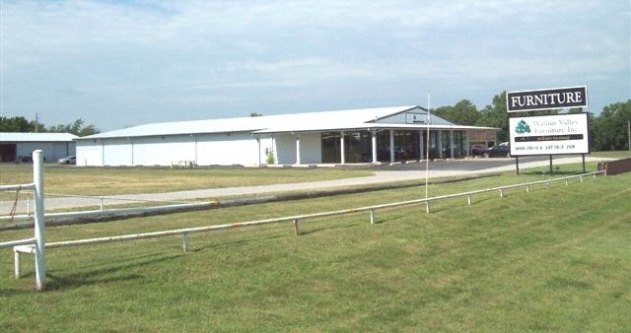
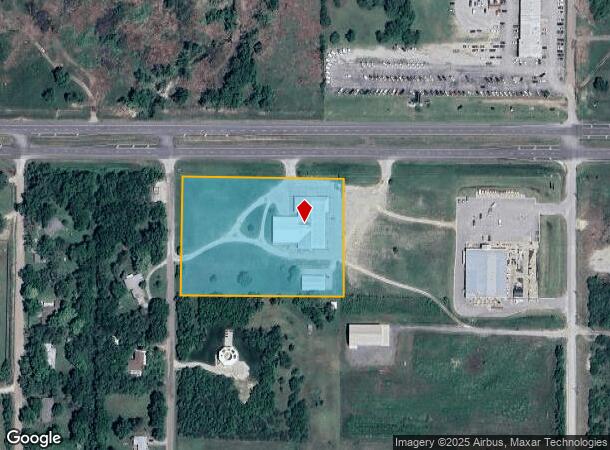
Property Record
10187 Sw Us Highway 54, Augusta, KS 67010

NEARBY LISTINGS FOR SALE OR LEASE
Property Detail
10187 Sw Us Highway 54
299-30-0-00-00-001-01-0
S30, T27, R04E, ACRES 4.2, BEG 714.39W NE/C NE1/4 S435.6 W500 N435.6 E500 TO POB LESS ROW
Wholesaleoutletdiscountstore
Butler
X
Kansas
20015C0495F
4.20 AC
2023
Augusta/El Dorado
2024
Wichita
020204
Wichita, KS
18,145 SF
DEMOGRAPHICS near 10187 Sw Us Highway 54
1 Mile
3 Mile
5 Mile
2024 Total Population
288
5,181
13,107
2029 Population
294
5,320
13,384
Pop Growth 2024-2029
+ 2.08%
+ 2.68%
+ 2.11%
Average Age
44
40
40
2024 Total Households
109
2,073
5,098
HH Growth 2024-2029
+ 1.83%
+ 2.70%
+ 2.20%
Median Household Inc
$130,000
$57,034
$62,861
Avg Household Size
2.50
2.40
2.50
2024 Avg HH Vehicles
3.00
2.00
2.00
Median Home Value
$303,030
$163,561
$180,637
Median Year Built
1990
1974
1977
Nearby Places
- Restaurants
- Banks
- Shops
- Fitness
- Groceries
PUBLIC TRANSPORTATION
AIRPORT
Wichita Dwight D Eisenhower Ntl
DRIVE
WALK
Distance
Wichita Dwight D Eisenhower Ntl
32 min
23.7 mi
Freight Ports
Tulsa Port Of Catoosa
DRIVE
WALK
Distance
Tulsa Port Of Catoosa
219 min
206.1 mi
SALE & LEASE HISTORY
LISTING DATE
SALE/LEASE

Jun 12, 2024
For Sale
Nearby Properties
Address
Land Use
TOTAL SIZE
Lot Size
Zoning
Address
Land Use
TOTAL SIZE
Lot Size
Zoning
5.09 AC
Address
Land Use
TOTAL SIZE
Lot Size
Zoning
4.80 AC
Address
Land Use
TOTAL SIZE
Lot Size
Zoning
8.40 AC
Address
Land Use
TOTAL SIZE
Lot Size
Zoning
15,184 SF
136.70 AC
Address
Land Use
TOTAL SIZE
Lot Size
Zoning
32,876 SF
1.40 AC
Address
Land Use
TOTAL SIZE
Lot Size
Zoning
3.30 AC
Address
Land Use
TOTAL SIZE
Lot Size
Zoning
3.20 AC
Address
Land Use
TOTAL SIZE
Lot Size
Zoning
120,432 SF
15 AC
Address
Land Use
TOTAL SIZE
Lot Size
Zoning
32,047 SF
1.10 AC
Address
Land Use
TOTAL SIZE
Lot Size
Zoning
0.90 AC
Address
Land Use
TOTAL SIZE
Lot Size
Zoning
28,144 SF
17.60 AC
Address
Land Use
TOTAL SIZE
Lot Size
Zoning
1,457 SF
6 AC
Address
Land Use
TOTAL SIZE
Lot Size
Zoning
12,342 SF
5.30 AC
Address
Land Use
TOTAL SIZE
Lot Size
Zoning
9,800 SF
3.20 AC
Address
Land Use
TOTAL SIZE
Lot Size
Zoning
16,359 SF
0.76 AC
Address
Land Use
TOTAL SIZE
Lot Size
Zoning
6,250 SF
0.22 AC
Address
Land Use
TOTAL SIZE
Lot Size
Zoning
11.60 AC
Address
Land Use
TOTAL SIZE
Lot Size
Zoning
33.10 AC
Address
Land Use
TOTAL SIZE
Lot Size
Zoning
19,120 SF
3.20 AC
Address
Land Use
TOTAL SIZE
Lot Size
Zoning
0.36 AC
Address
Land Use
TOTAL SIZE
Lot Size
Zoning
7,200 SF
10.30 AC
Address
Land Use
TOTAL SIZE
Lot Size
Zoning
91.80 AC
Address
Land Use
TOTAL SIZE
Lot Size
Zoning
4,587 SF
2 AC
Address
Land Use
TOTAL SIZE
Lot Size
Zoning
18,632 SF
7.40 AC
Address
Land Use
TOTAL SIZE
Lot Size
Zoning
35,930 SF
3.20 AC
Address
Land Use
TOTAL SIZE
Lot Size
Zoning
Address
Land Use
TOTAL SIZE
Lot Size
Zoning
1.10 AC
Address
Land Use
TOTAL SIZE
Lot Size
Zoning
7,022 SF
1.70 AC
Address
Land Use
TOTAL SIZE
Lot Size
Zoning
3,996 SF
1.40 AC
Address
Land Use
TOTAL SIZE
Lot Size
Zoning
14,226 SF
0.22 AC
The World's #1 Commercial Real Estate Marketplace
Connect with us
© 2025 CoStar Group
The information above has been obtained from sources believed reliable. While we do not doubt its accuracy we have not verified it and make no guarantee, warranty or representation about it. It is your responsibility to independently confirm its accuracy and completeness. Any projections, opinions, assumptions, or estimates used are for example only and do not represent the current or future performance of the property. The value of this transaction to you depends on tax and other factors which should be evaluated by your tax, financial, and legal advisors. You and your advisors should conduct a careful, independent investigation of the property to determine to your satisfaction the suitability of the property for your needs.